Thursday 23rd November to Sunday 3rd December 2023
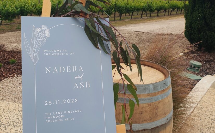
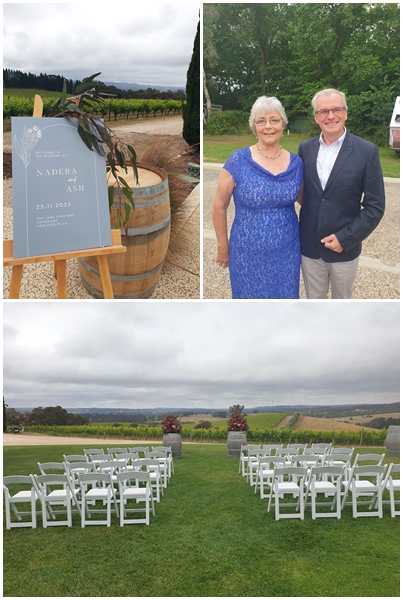
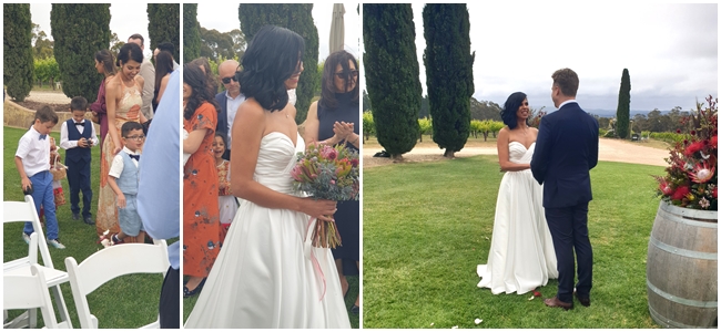
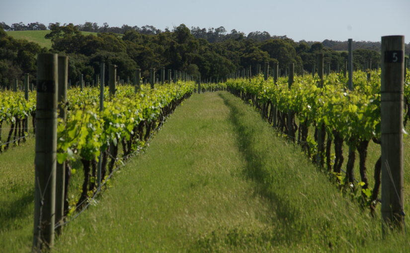
We left the lovely little caravan park at Mt Compass and headed for the hills…..the Adelaide Hills. We were there for the wedding of my second son, Ashley, to his fiancé Nadera. The wedding venue was The Lane vineyard in Hahndorf, 40 km southwest of Adelaide.
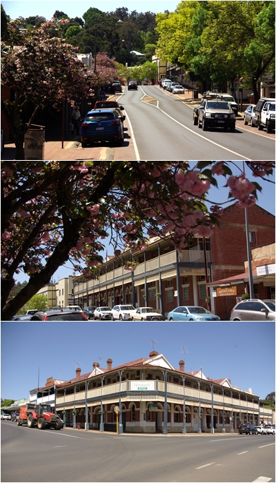
It was just a short 53 km drive for us from Mt Compass to Mount Barker caravan park, our camp site for the four days in the Adelaide hills. We met Ash and Nadera in Hahndorf for a drink on Thursday, then the two families, 28 of us in all, enjoyed a meal together in an Afghan restaurant on the Friday night, with the wedding on the following Saturday. It was an exceptional venue for an exceptional wedding.
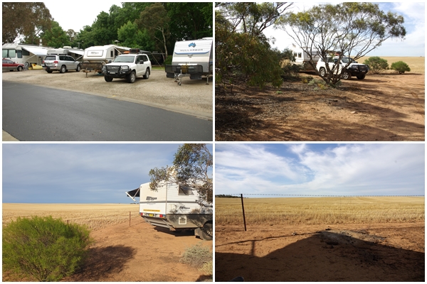
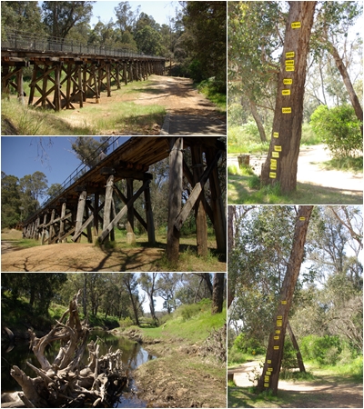
We stayed in Mount Barker on the Sunday and started to make our way home on Monday morning, first stop being a free camp near Kulwin in Victoria. We had a day or two to spare before fulfilling an appointment at the Forbes Showground, so we made a detour to Griffith, a town in the NSW Riverina that we have always bypassed. We spent two nights at an amazing free camp at Lake Wyangan, 12 km out of Griffith. We only spent a brief few hours in town, preferring to relax at the camp.
The next day was an overnighter at the Forbes Showground for the opportunity for another look at the facilities and pavilions in preparation for our 2024 BOG Muster there in September.
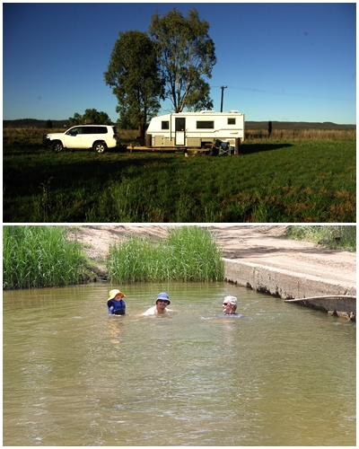
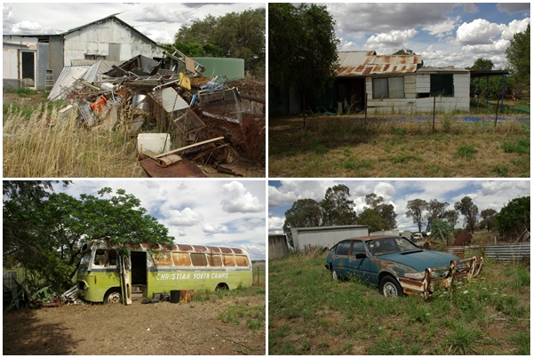
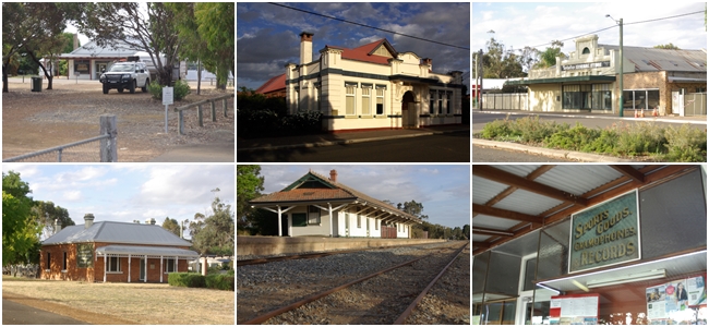
The final stop was in the little locality of Arthurville, 50km south of Dubbo, to check out a block of land that Nicole and James have recently purchased as a hobby/holiday property. Affectionately known as El Dumpo, the previous owners left a substantial amount of rubbish in and around the rather derelict house, that Nicole and James are systematically removing.
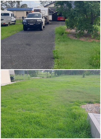
Despite our home in Taree being vacant for the last month of our 5 month journey, it was overgrown with grass and weeds, as the last few weeks saw a considerable amount of rain fall in the area. Now the work begins, not only to clean up Henrietta and Blake, but to tidy up the yard as well.
Thanks for following us on our journey again. This is likely to be the final post of Henry and Jake’s (Henri and Blakes) Adventures.
TRIP STATISTICS
Total time away: 158 days (5 months and 5 days)
Distance travelled by Henrietta: 22,265 km
Distance travelled by Blake: 18,110 km
Number of campsites: 80
Fuel consumed: 4,590 litres
Total fuel cost: $10,135
Range of fuel price cents per litre: $1.80/L to $3.10/L (average $2.20/L)
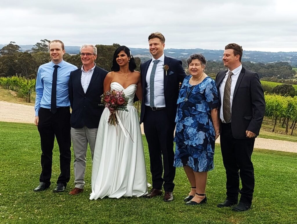
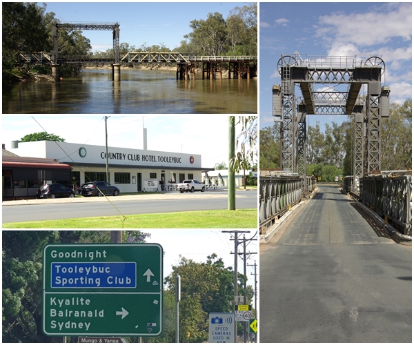
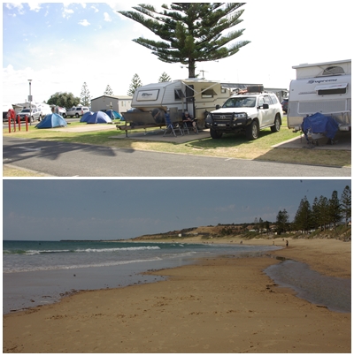
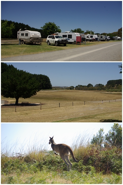
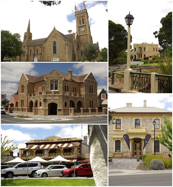
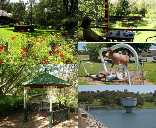
Leaden skies did not dampen the ceremony, nor the preparation of that good looking couple about to leave Mount Barker caravan park for the wedding venue, The Lane Vineyard.left to right: The procession started with the page boys and flower girls, Ash and Nadera’s nieces and nephews. Pete (in the waistcoat) was carrying one of the rings. They were followed by Nadera in a stunning dress, to join Ash.Ash’s immediate family from left to right: Dave (youngest brother), me, Nadera, Ash, Helen (the boys mum) and Trev (older brother). Once all the family photos were completed outdoors the rain started so we all quickly retreated to the bar/restaurant.top left: our campsite at the Mount Barker caravan park, 10 minutes drive from the wedding venue. Other photos: our free camp on the first night leaving Mount Barker, near Kulwin in Victoria, adjacent to a wheat crop ready for harvest.Almost home….well at least we are now in our home state of NSW, having crossed the Murray River at Tooleybuc. If Tooleybuc isn’t a weird enough town name, what about Goodnight? Though Goodnight is not really a town, more like a locality.Our campsite at Lake Wyangan, just outside Griffith, with a deer farm next door. The only building I thought to photograph whilst in town was the very art deco Griffith War Memorial Museum. It was the pink fence that drew my attention.Our camp on Nicole and James’ property in Arthurville. James and Conner took Carol and I to a local creek for a swim. Carol declined the opportunity to swim.Just some of the treasures lying around the Arthurville property “El Dumpo”.Home at last. With only having lived in our home at Taree for 12 months before departing for WA, we were homesick within the first week. Thus we are so pleased to be home again, though there’s a bit of work to be done to get the yard looking good again.All of our travels, with the 22,265 km 2023 WA trip shown in light green. (It’s a little hard to see).
Wednesday 1st November to Wednesday 22nd November 2023
(Warning: this a long post. Grab yourself a drink before sitting back to share in our latest journey.)
There are three significant peninsulas along the South Australian Coast. The most westerly and largest is the the Eyre Peninsula between Ceduna and Port Augusta (named after explorer Edward John Eyre). Next and second largest is the Yorke Peninsula, south of Port Augusta (named by Matthew Flinders on March 30, 1802, after the Right Honourable Charles Phillip Yorke). The smallest of the three is the Fleurieu Peninsula south of Adelaide (named after Charles Pierre Claret de Fleurieu, the French explorer and hydrographer, by the French explorer Nicolas Baudin as he explored the south coast of Australia in 1802).
The Eyre was the first peninsula we reached, but having circumnavigated it in 2020, we had planned to bypass it, but with Henrietta in disparate need of a service and new rear tyres we stopped in at Streaky Bay on the west coast for a few days to get the work done.
With Henrietta feeling better we made a b-line for Port Augusta, then south to the Yorke Peninsula. However, Henrietta wasn’t feeling too well after all, having difficulty staying in the lane. We did manage to sort the problem out, but not before travelling 1,400 nerve wracking kms.
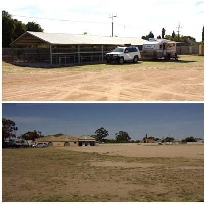
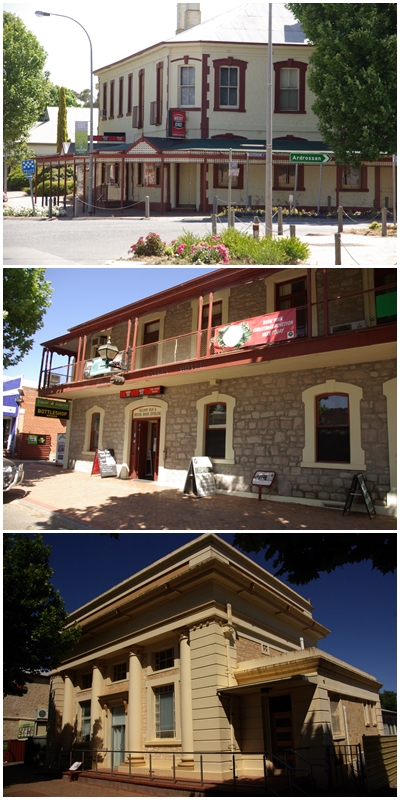
We made one overnight stop before reaching Kadina at the northern end of the Yorke. We spent nine days on the Yorke and divided our time across 6 campsites, although two were just one-nighters on friends driveways. We zig-zagged across the peninsula over those nine days and reckon we got a pretty good feel for it, despite missing fifty percent of its east coast.
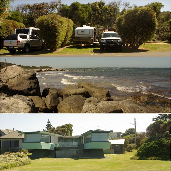
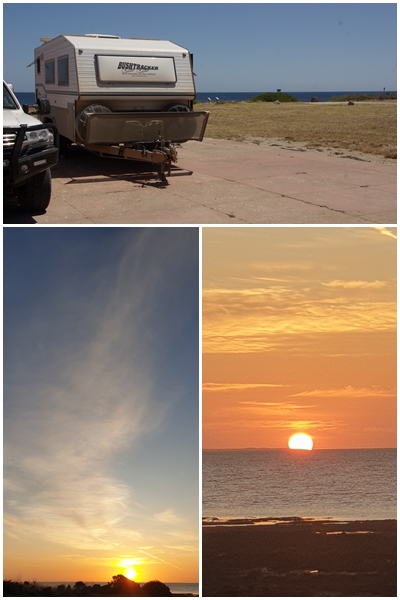
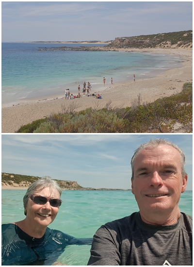
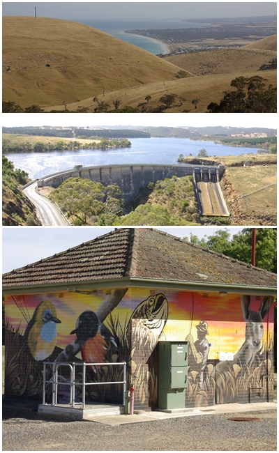
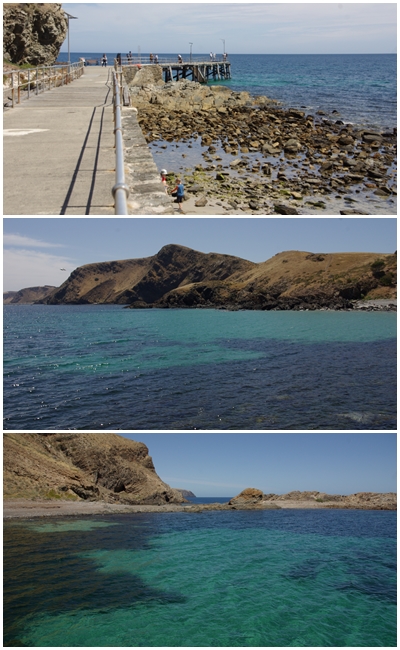
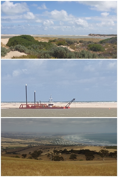
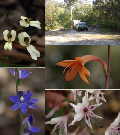
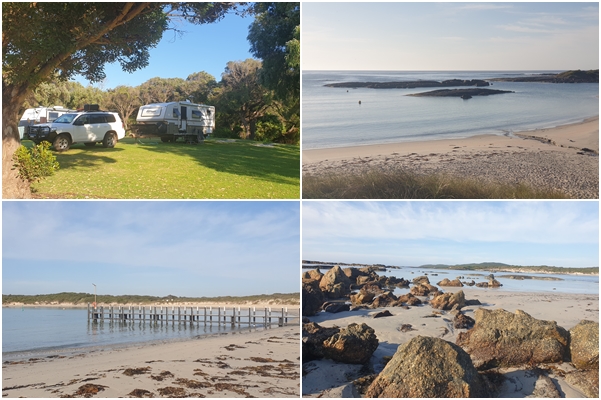
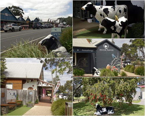
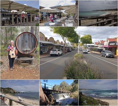
From the Yorke, it was off to the Fleurieu, also for nine days, planning to camp at three locations for three days each from which we would do day trips to cover the extent of this peninsula. Our first camp was at Christie’s Beach, just 30km south of Adelaide. Next, we planned to go to Rapid Bay on the southern end of the peninsula. However it was booked out , so we opted for Mount Compass in the centre of the peninsula. The weather forecast at our third campsite, Goolwa on the western coast, was diabolical with winds expected to exceed 45 kph with gusts exceeding 60 kph over the three days. We were very happy with our campsite at Mt Compass, so extended our stay there to six nights, with winds only forecast to reach the mid thirties. Despite the better forecast, we stayed indoors on our last day, as it was too unpleasant to travel and sightsee anywhere.
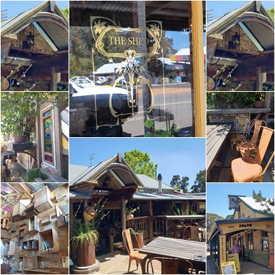
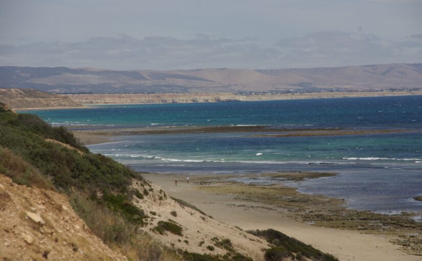
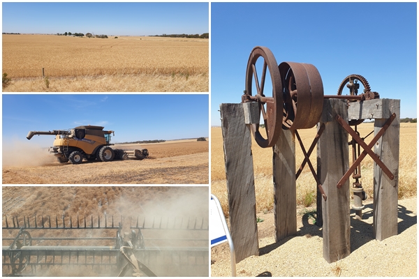
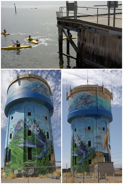
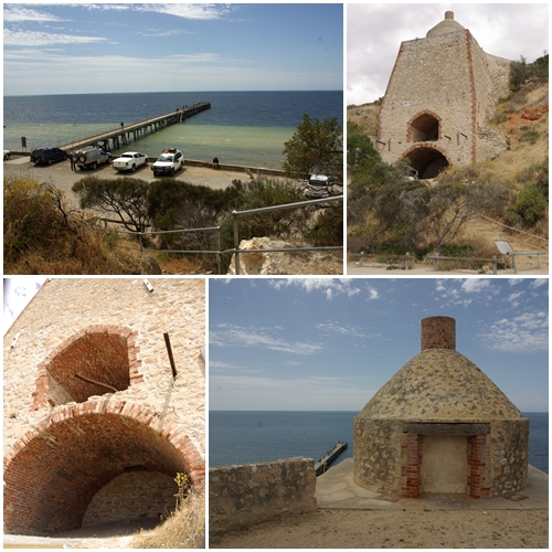
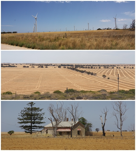
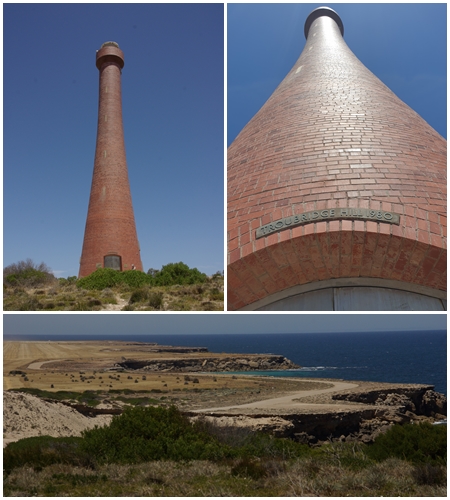
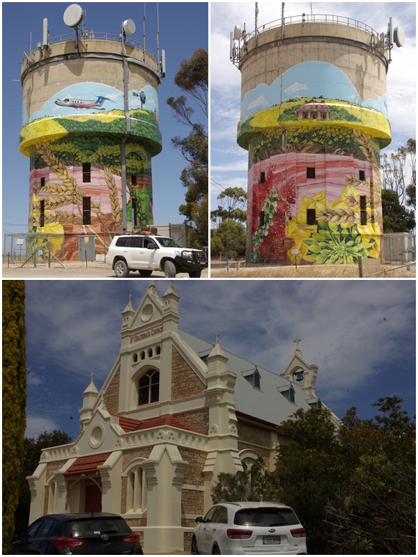
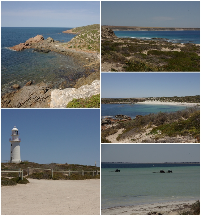
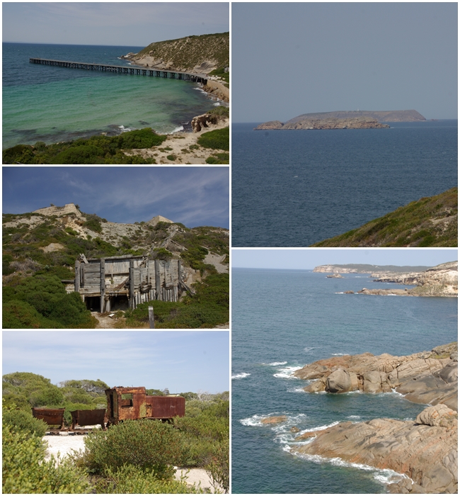
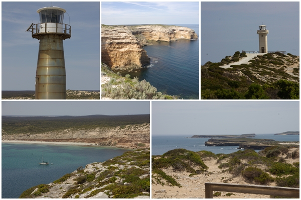
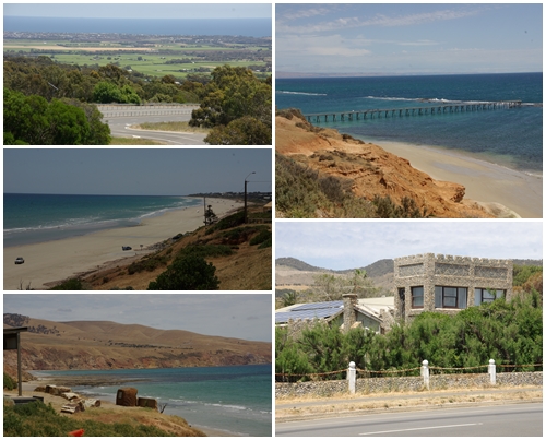
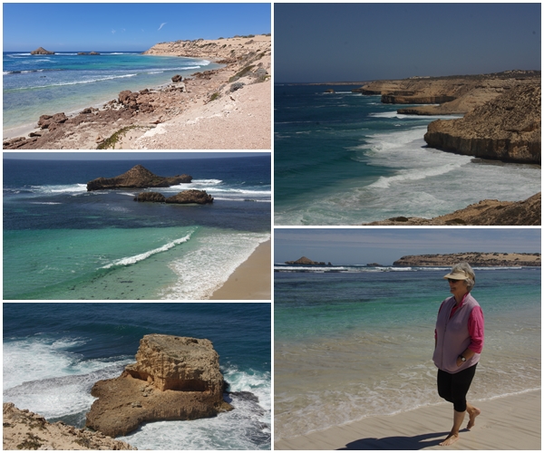
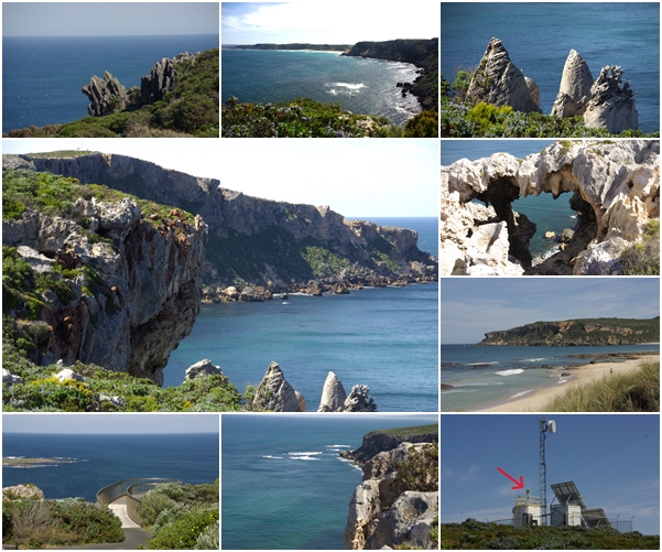
What was our take-away from the peninsulas? Firstly, they are all quite different, but with a few similarities. They were all very dry. They are surrounded by pristine waters. The weather was windy most days, with temperatures in the low 20s. Many beaches on the Yorke were edged with rocks, so access to the water was difficult. The shore into the water was predominantly very flat, so at most tides you’d need to walk several hundred metres for the water to get above your knees. Both the Eyre and the Yorke were predominantly flat, with broad acre crops dominating the landscape. This was particularly the case for the Yorke, with wheat, barley, lentils and canola all ready for harvest, stretching from coast to coast. The Yorke also has an abundance of timber jetties, with one at most of its coastal towns. The Fleurieu, however, is quite different with hills, often steep, making this peninsula more suited to grazing. The Fleurieu was also the greenest and our favourite of the three peninsulas.
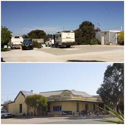
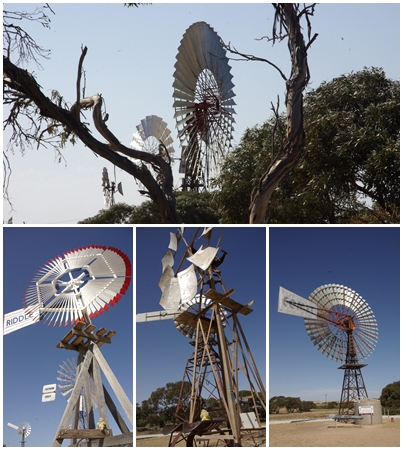
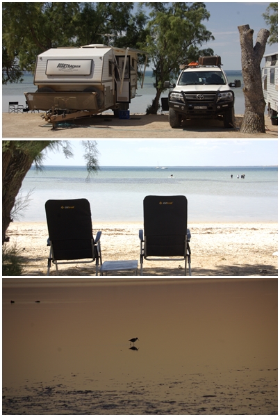
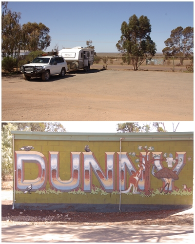
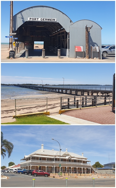
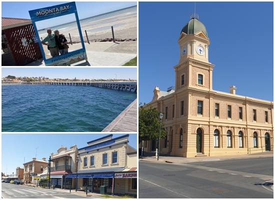
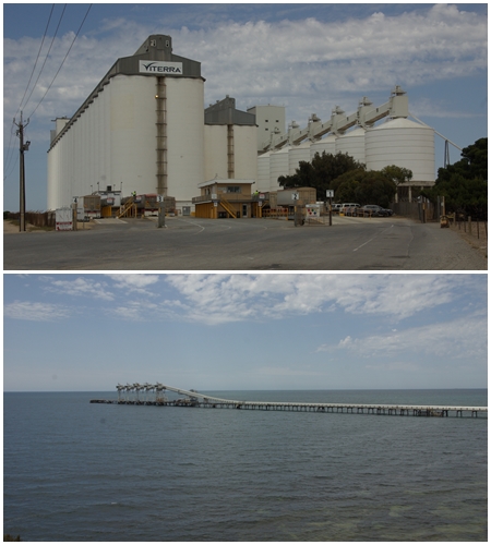
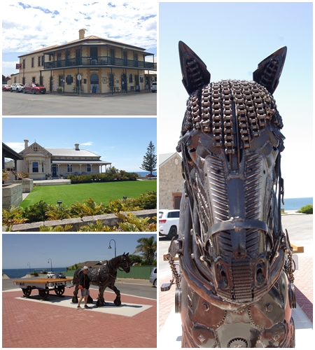
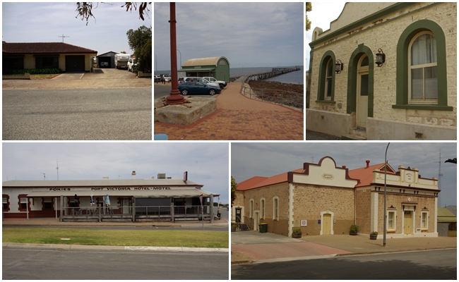
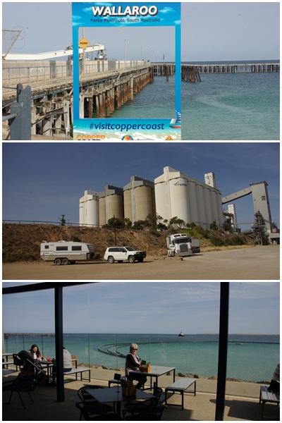
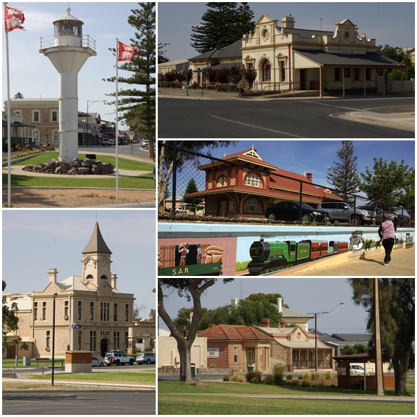
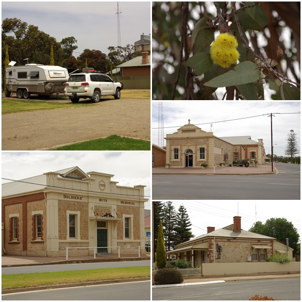
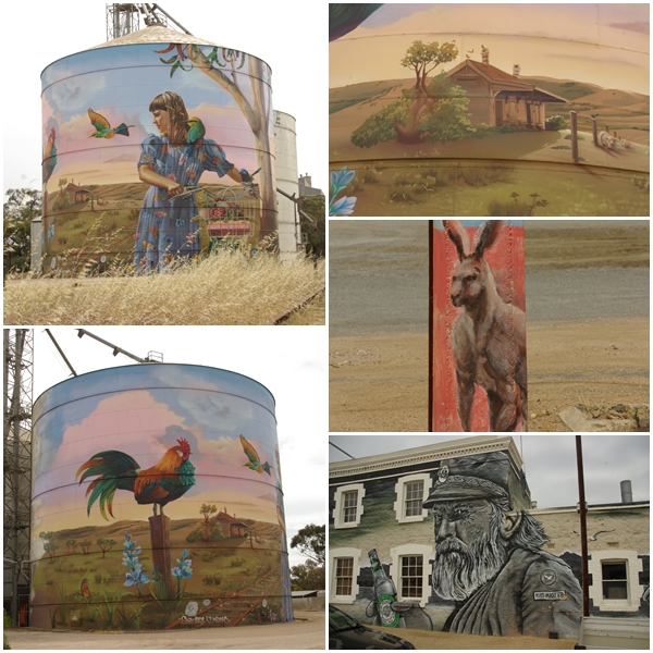
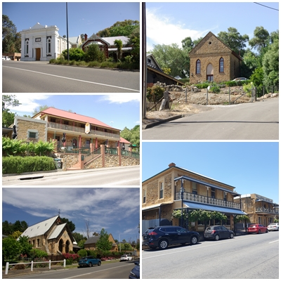
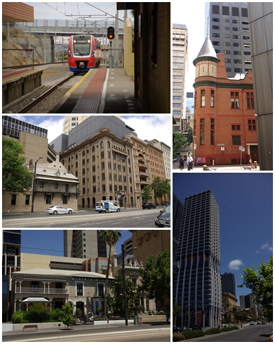
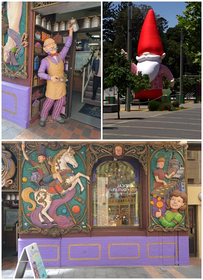
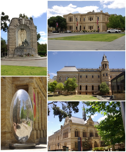
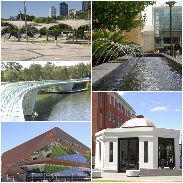
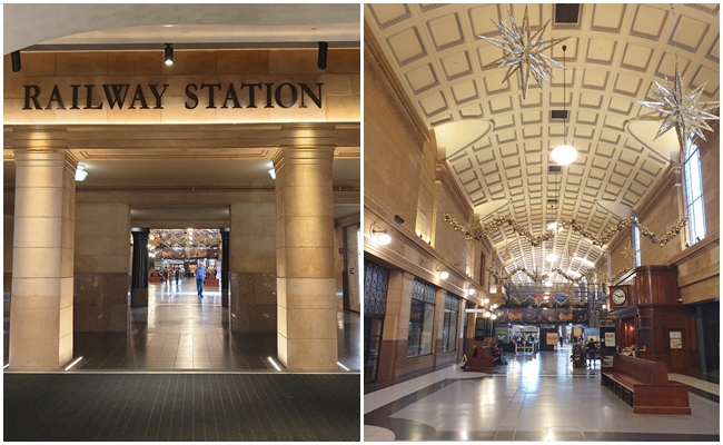
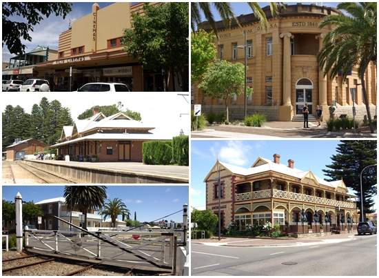
Our first camp after leaving Maralinga was Penong, a quaint little town west of Ceduna. We had planned to travel further, but when fuelling up at the eastern end of the Nullabor we found we had a strong head-wind, so decided to stop at Penong. Having stayed there in 2020, we knew it was a nice little van park.One claim to fame in Penong is its collection of windmills, one of which, a Comet named Bruce, is the largest windmill in Australia. Yum Yum was fascinated and enjoyed sitting on two of the smaller windmills.Our site at the Streaky Bay Foreshore Caravan Park gave us lovely views of the bay, but a long walk was required to find water deep enough in which to swim. We managed to catch up with some local BOG friends, Lloyd and Heather, whist we were there.A quick overnight stay at Iron Knob on the eastern side of the Eyre. We have stayed there a few times. Despite having built new toilets since our last stay, they have retained the old Dunny!460 km east of Streaky Bay is Port Germein, on the Yorke Peninsula (top two photos). Whilst we were having some morning tea overlooking the jetty, a lady came up to us to chat about our Bushtracker. She advised us that her parents owned one. When questioned, she said they were Lloyd and Heather from Streaky Bay. It’s a big country, but a small world. A little further south we stopped and strolled through Port Broughton, with its magnificent Broughton Hotel.Our first two nights on the Yorke were spent at the Kadina Showgrounds. Not a particularly picturesque location, but with only three campers it was pretty quiet and was a good launching site for looking around the northern end of the peninsula.I have a soft spot for old buildings. These are some of the ones in Kadina.120 km southwest of Kadina is the town of Moonta (bottom and right), and nearby Moonta Bay.As we made our way south towards our next camp we stopped off at the inland town of Maitland, proclaimed in 1872. Old buildings included the Maitland Hotel (1874), the Yorke Valley Hotel (1877) and the Bank SA building (1928).BOG friends who live in Minlaton, south of Maitland, have retired from farming but retain ownership of much of their land, which they now lease to Adam who grows wheat (top left), barley, lentils (middle and bottom left) and canola. Adam allowed me to ride with him as he harvested lentils. A fascinating experience. Between Maitland and Minlaton is a display of the now abandoned Yorke Valley Dam, constructed in 1886 to collect rainwater for the peninsula, as no rivers or reservoirs exist. The bore head pictured was drilled to a depth of 126m. Powered by a 12 horsepower Blackstone engine, the resulting water was very salty, being then carted by horse and wagon to nearby dams where it was blended with fresh water. The Yorke Peninsula was connected by pipeline to the Murray River in the 1950s.Our second camp on the Yorke was at Port Minlacowie. Nothing of the port remains. The camp is one of about nine managed by the Yorke Council. They have very limited facilities. Fortunately this one had a relatively new long-drop toilet, and an old building slab enabled us to stay off the dry, burred grass. It was too cold and windy to bother having a swim.From Port Minlacowie camp we explored much of the east coast including Port Vincent with a school group in kayaks and sail boats, and Stansbury with its water tower murals. The standout for us in Stansbury was the worst coffee we have ever bought. We both watered the grass with the coffee as it was too awful to drink.Our exploration also took us past the Wool Bay lime kilns. Built between 1900 and 1910, the kiln was used to burn lime to be used as building mortar, and was exported from the jetty to Adelaide. The kiln was not a success due to problems resulting from its cliff top location and wind variations.Four km south of Wool Bay is the Port Giles Viterra grain handling facility, opened in May 1970, able to load 800 tons of grain per hour.We stopped for lunch at the Edithburgh Hotel. Edithburgh is a small town on the east coast, with a jetty, as do most towns, and a new attraction being a full size steel Clydesdale horse in the main street, erected to coincide with the jetty’s 150th anniversary, which was restored for the anniversary.The Yorke Peninsula has plenty of wind, wheat and worn-out farm structures.On the south eastern corner of the Yorke stands the Troubridge Hill Lighthouse. Built in 1980 it is one of only a handful of brick lighthouses in Australia. What is unique about Troubridge is that the special wedge shaped clay bricks have not been rendered or painted.On our return trip to camp we passed through Yorketown, with its water tower mural and elegant St Columba’s church.The following day we moved camp to the little town of Warooka, which provided an inexpensive camp site at the rear of the bowlo (no pics unfortunately). After setting up camp we explored the northern coast of the peninsula’s “foot”, taking in the towns of Corny Point (pictured), Port Turton and Point Souttar as well as Burners Beach, Dunn Point and Gleesons landing. All too cold for a swim.On our second day at Warooka we did the southern coast of the “foot” from Sturt Bay to Marion Bay and into the Innes National Park. The Stenhouse Bay jetty and ruins (left photos) are the remnants of a Gypsum plant, with gypsum coming from the nearby Marion Lake. Commencing in 1934, the works ceased in 1973. The works are now part of the national park.Inneston was a company town of the Yorke Peninsula Plaster Company, with the town existing from 1913 to 1930, when the Great Depression forced the closure of the plaster works. Not much remains, but seven structures have been restored by the national park for use as holiday accommodation.Continuing further into the national park we visited the West Cape lighthouse (top left) and the Cape Spencer lighthouse (top right). The views from West Cape across Pondalowie Bay and the South, Middle and North Islands were spectacular (bottom).Despite the increasing heat, no beach had presented itself as a nice swimming beach until the last beach in the national park, Shell Beach. Beautiful. The water was clear and cold, whilst the sand was almost too hot to walk on. On our return drive to Warooka, the temperature reached 40 degrees.We packed up at Warooka and returned north to Minlaton early to hopefully rectify Henrietta’s drunkenness on the road. We put a new pair of tyres on the front. We then went to the other end of town to spend a night with BOG friends Rob and Glenda, to be joined by other BOG friends Grahame and Nerilee for a wonderful afternoon and evening (top left). After a cooked breakfast with our BOG friends we made a late start towards Moonta Bay, via Port Victoria (other pics) and Port Hughes on the west coast.After a night on the driveway of family friends Nathan and Tia at Moonta Bay, we hitched up and finished our exploration of the Yorke with a visit to Wallaroo, with great views and coffee at the Shores Eatery adjacent to the jetty and grain loading facilities.Walleroo is bursting with beautiful historic buildings.Our next camp was the little inland town of Bute at the very top of the Yorke Peninsula. We stayed just one night in a quaint council run caravan park with only six sites and magnificent yellow-flowering gums. Bute is an aging town, with a few historic buildings remaining.Bute’s main attraction now is the beautiful art on the retired grain silo. Power poles in the town also feature local wildlife, though not to the standard of the silo art. The town of Port Wakefield, just east of the Yorke, sports a magnificent mural on the wall of the Rising Sun Hotel.From Bute we had a relatively short 170km drive south through Adelaide to the west coast of the Fleurieu Peninsula and our camp at the Christie’s Beach caravan park. Not our favoured camp type, but the choices are limited near Adelaide.On our first full day on the Fleurieu Peninsula we toured through the hills south of Adelaide, driving through Happy Valley, Coromandel Valley, Clarendon (all left and top right), Kangarilla, McLaren Flat and McLaren Vale. Stopped for coffee in McLaren Vale but the town (and the coffee) lacked oomph. Then on to Willunga (bottom right), a lovely little town with a great vibe from cafes and cool shops.Continuing our drive from the hills, we joined the west coast at Sellicks Beach and followed “Route 31” along the coastal towns north , back to Christie’s Beach. Too cold and windy to swim anywhere. The unusual castellated house and fence at bottom right is entirely clad with round river rocksOn our third and last day at Christies Beach, we caught the train to Adelaide for a wander around. Many of the preserved historic buildings are dwarfed by the moderns.The front of Blackeby’s Sweets Shop was a sight to behold. We didn’t venture in (need to preserve our teeth). The big jolly red fella can be seen throughout the city.We spent a few fascinating hours in the Adelaide Museum, before wandering up North Terrace past the State Library, Art Gallery and University.After a free bus tour of the city we wandered through the Riverbank Precinct with the Festival Centre and Convention Centre (left photos). Top right is the State Library, bottom right is a café outside the Space Discovery Centre.The entrance to the Adelaide Railway Station from the Riverside Precinct is stunning, as is the interior.We had planned our next camp to be at Rapid Bay near the south end of the Fleurieu. It was booked out so we opted for Mount Compass Caravan Park. Though it is part of the Big 4 chain, it is far removed from that style. No pool, playground or jumping pillow. It is the nicest van park we have every stayed in. And the view from the balcony is awesome, Pity it is too cold and windy to enjoy it for too long. What is wrong with SA’s weather?On our first full day at Mt Compass we took a drive along the western coast of Fleurieu through Myaponga (weird name), past the Myaponga Reservoir, and views to the coast………..continuing along the coast to Second Valley, a lovely protected beach and jetty. Too nice to resist, I took a swim, and it was not too cold at all.The following day we took a drive to Victor Harbour on the peninsula’s west coast. It’s a tourist town, currently set up for schoolies. The iconic horse-drawn tram to Granite Island was not operating, so we settled for a short walk through town past (clockwise from top left) the art-deco Victa Cinema (1923), Bank SA building (1848), the Anchorage Hotel (1905), and the railway station (1926) and hand operated railway gates.Day 5 at Mt Compass we drove to the pretty town of Strathalbyn. Not knowing what to expect of the town it took quite by surprise. A charming town with preserved historic buildings, picturesque park and no less than six antique shops, three of which we checkout out. A bit pricy for our budget, but some wonderful stuff nonetheless.From Strathalbyn we passed through very windy Goolwa and out to the mouth of the river Murray from Hindmarsh Island. Then via a lookout with a great view to the southeast over Goolwa with the Coorong National Park behind.Our journey through the three peninsulas (pale green). The scale of the map makes it impossible to trace all our tracks through the Yorke and especially the Fleurieu Peninsula.
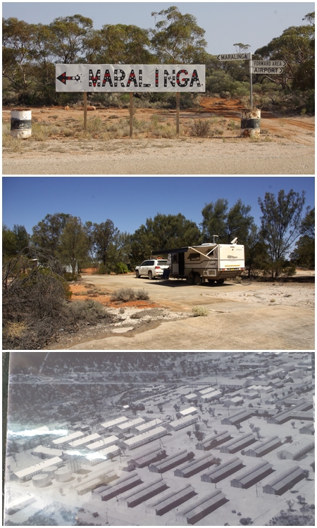
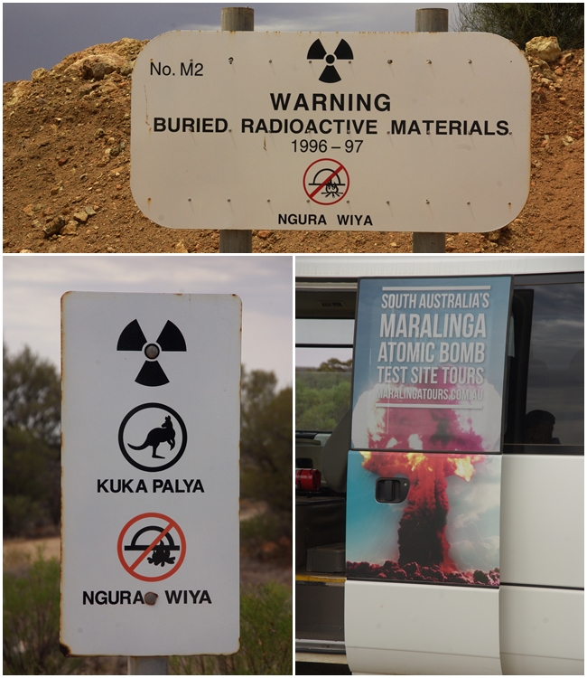
This is the appointment we’ve been working towards over the past few weeks, the final Maralinga Tour for 2023. Having paid $250 per person for the tour we didn’t want to arrive late and miss it. What did we get for our $500? Two nights luxury accommodation in our van, toilet facilities similar to those on a construction site (i.e. in shipping containers) and a 7 hour tour around the facility in a 20-seater mini bus with a driver/guide.
However, despite what we thought was a bit of price gouging, it was nonetheless very interesting, though there was really very little to see.
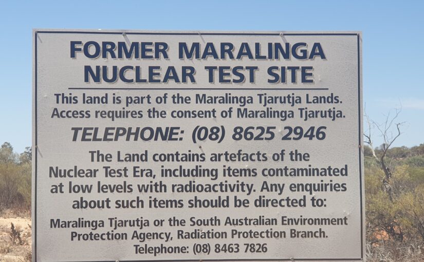
Aboriginal people have occupied the Maralinga Tjarutja lands since time immemorial. The people are part of the Western Desert culture. They have strong cultural and traditional links with the Pitjantjatjara and Yankunytjatjara people to the north and the Tjuntjuntara people to the west. Whilst official documentation refers to the displacement of the Aboriginal people, our guide Robin, who has been living in the region on and off for 50 years, and is married to a local Aboriginal woman, advised the tour that no Aboriginal people were living on the site at the time, though they did access it and for hunting and travel between tribes and settlements.
With the agreement of the Australian Government, Britain tested atomic weapons at three sites on Australian territory: the Montebello Islands off Western Australia, and Emu Field and Maralinga in South Australia. The testing took place from 1952 to 1963, mostly at Maralinga. Australian authorities did not discover the extent of the contamination at Maralinga until 1984, just before the land was to be returned to its Aboriginal owners.
The Maralinga site occupied approximately 3,300 square kilometres.
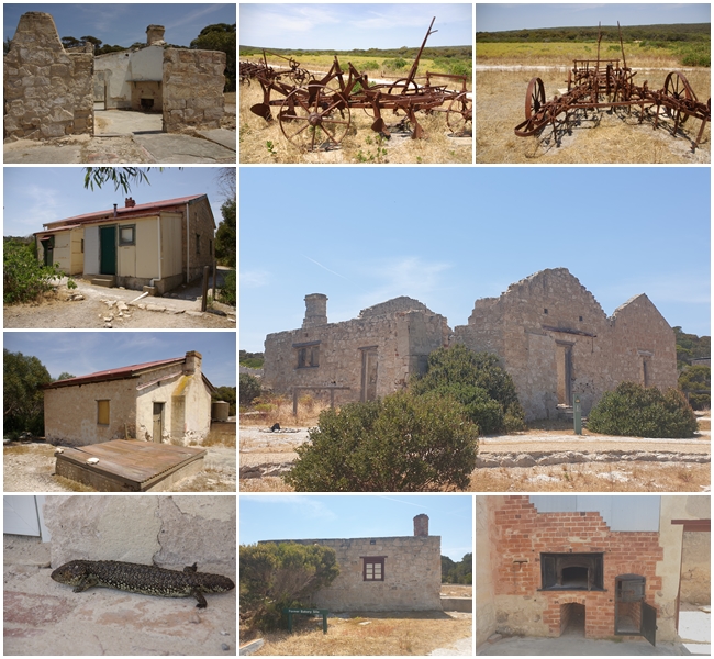
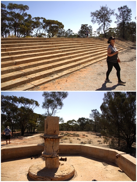
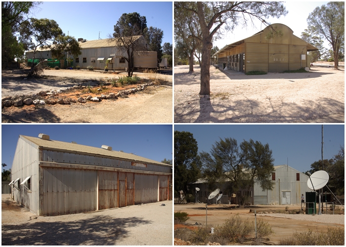
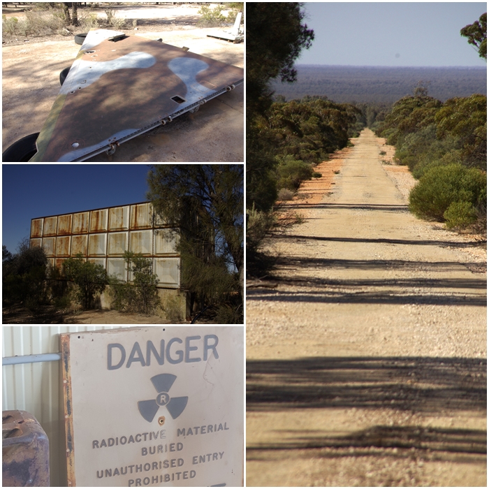
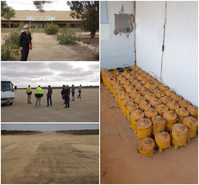
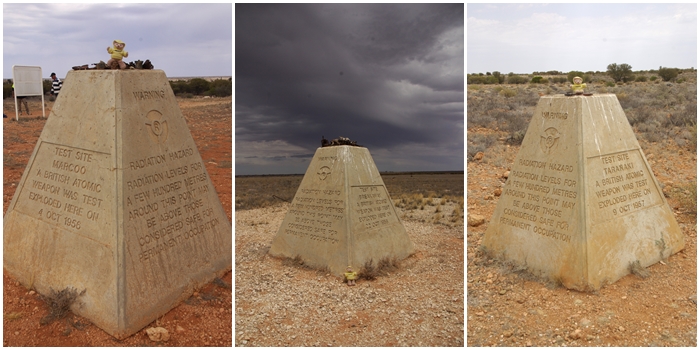
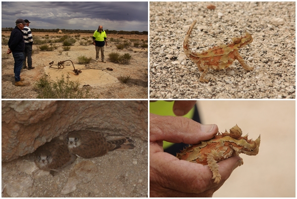
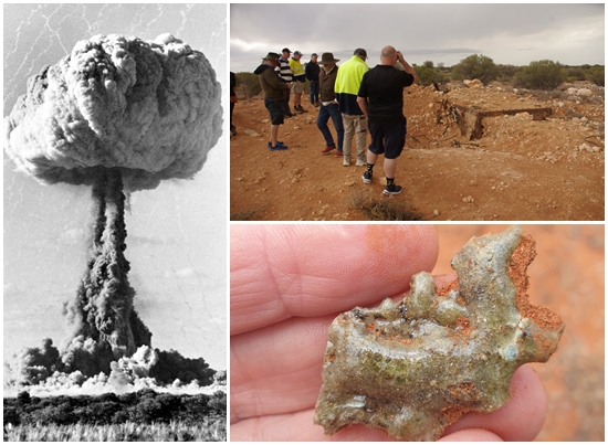
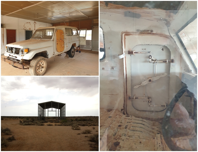
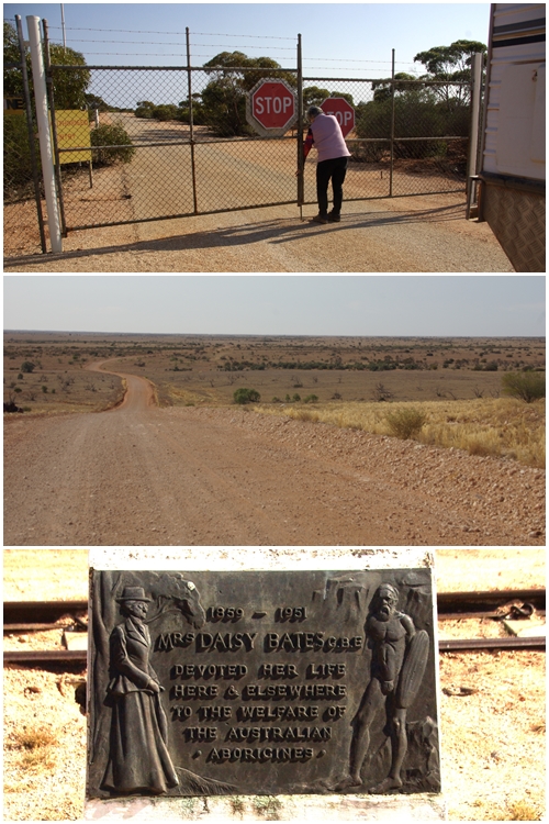
We set up camp on one of the multitude of concrete slabs across the Maralinga Village Area that once supported sleeping quarters and administration buildings to serve the 3,000 military, scientific and civilian workers at any one time, who were all male. Women were forbidden to set foot on the site.The steps behind Carol lead up to what was once an Olympic size swimming pool, which has now been backfilled. The foreground structure in the bottom pic was a fountain, which we assume was to cool the bore water that was likely used for the pool.Very few buildings remain in the Village or across the broad Maralinga site. Most were either demolished, or shipped off and reassembled in other locations around the state.Some artefacts that have been collected or preserved, plus one of the many roads surveyed and constructed by Len Beadell. Len surveyed the entire Maralinga site as well as the Woomera rocket testing facility in SA.In addition to the village area of the site, a large airfield was constructed, with regular military and civilian flights, up to 30 per day. The airstrip is one of the longest in the southern hemisphere and has never required any surface repairs. Rainwater falling on the runway was channelled to a dam and used as drinking water in the Village. Some artefacts at the airfield include these kerosene landing lights.Ground Zero: Following the clean up of the test sites, plinths were placed at most of the seven detonation sites, three of which we visited; Marcoo, 4th Oct 1956 1.5kT, detonated at ground level creating a 30m deep crater; Breakaway, 22 Oct 1956 10kT detonated atop a 10m high tower; and Taranaki, 9 Oct 1957 27kT detonated from tethered balloons at 1,000 feet above ground. Yum Yum enjoyed the tour.In 1958 another site named Tufi was prepared for another detonation, with the bomb to be suspended from tethered balloons. This detonation didn’t proceed, however the multitude of concrete plinths used to tether the balloons have been retained; During the tour we came across this little thorny devil, and three Peregrine Falcon chicks part way down a well that was dug in 1878. Mr and Mrs Falcon make this a regular home.A photo of one of the actual detonations at Maralinga; at several of the sites, steel bunkers were placed nearby, with personnel inside (according to our tour guide), to test the impact of the blast. One of the bunkers tipped over during the blast. Not an experience I’d like to endure. Other resources indicate the bunkers contained delicate instrumentation. I guess a worker could be deemed “delicate instrumentation”. The bunker has been partially re-excavated exposing the entrance door; The ground at Breakaway was vaporised, becoming so hot from the blast that the soil vitrified, turning into glass. Some fragments of what was once a large green glass sheet still remain.The Brits did a dodgy clean up of the site in 1967. In 1986 the Australian Government established a Technical Assessment Group to undertake a risk assessment of the condition of the lands. Extreme contamination was detected in several areas so a complete clean-up was undertaken, burying over 350,000 cubic metres of contaminated soil, plus planes and vehicles used during the bomb testing and all of the equipment used to decontaminate the site. This Toyota had the driver’s side welded shut and a ship’s bulkhead door fitted to the passenger side to completely seal the cabin, with an air filtration system on the roof (now removed and buried). In the rear, sealed from the cabin was instrumentation to determine contamination levels. Several of these vehicles were kitted out and used to survey the entire Maralinga site. The shed is one of two that remain near the detonation sites, erected in the 1980s as maintenance workshops for the clean-up machinery. The clean-up was completed in the year 2000, costing $108 million.Signs warning of the contamination, and the side of the tour mini bus. Kuka palya = meat good. Ngura wiya = camp no.Carol locking up the perimeter fence behind us, as we were the last of the tour group to leave the site on the following morning. Several km from the site the land drops down to the Nullabor Plain; At the crossing of the Trans Australian Railway line, about 80km south of Maralinga, stands a monument to Daisy Bates who worked tirelessly with the aboriginal people in the late 1800s – early 1900s. We couldn’t find the monument commemorating the joining of the west and west sections of the line in 1917.South Australia, showing the location of Maralinga.
Tuesday 24th October to Saturday 30th October 2023
After three months in the state of Western Australia it is time to leave and make our way east. From Kalgoorlie there’s generally two routes to travel east (excluding tracks such as the Anne Beadell Hwy), namely a northern route via the Great Central Road to Uluru, which we used coming west, or the southern route via the Nullabor. As we had an appointment at the eastern end of the Nullabor, that was the route we had to take.
By the time we broke camp in Kalgoorie, filled with water and did some grocery shopping it was mid-morning. We travelled south to Norseman where we stopped and had a look around town. We were there in 2020 during COVID so didn’t have a good look then. From Norsemen we headed due east. 80 km east of Norseman we stopped for lunch at the Ten Mile Rocks rest area and decided to call it a day, having travelled only 280 km from Kalgoorlie, but an easterly wind was getting up so best to get off the road.
The winds were forecast to ease on the following day, but become a very strong easterly the day after. So we made a dash across the Nullabor, covering 640 km after leaving the rest area, skipping a planned overnight stop, and stopping at the Old Telegraph Station near Eucla for two nights to sit out the windy day. We’re so glad we did as the wind howled all the following day and night. We had to keep the van windows closed. Unfortunately I had left one front window cracked open in Henrietta. Oh the mess inside, which took nearly an hour to mop up the worst of it!!
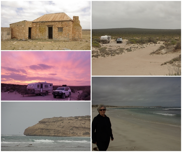
The wind didn’t ease until about 10:00am on our day of departure from the telegraph station, giving me time to do the clean up, and giving us more favourable head winds to continue east, crossing into SA just east of Eucla. We had ended up a few days ahead of time and tried to move our appointment forward, but to no avail. So we booked a camp in the Fowlers Bay Conservation Area on the coast for a few nights, but didn’t have time to reach it in one day so stopped at a very exposed free camp at the eastern end of the Nullabor. a relatively short 170 km the next day had us at the Mexican Hat campground about lunchtime. A lovely location until we realised the extent of the bee population, which kept us inside the van, rather than sitting outside, as we couldn’t relax with the little critters constantly around, despite us having placed a water source for them about 10m away. We did manage to do a few beach walks however, and evening drinks with neighbours, well away from the vans. A few bees found us but it was manageable, just.
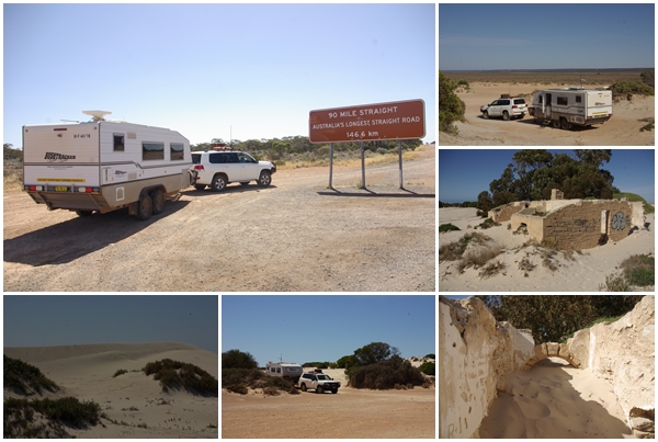
Our camp at Ten Mile Rocks east of Norseman. We realised we stayed there in 2020 whilst escaping WA before their lockdown. We setup well off the highway in a nice quiet location, with views to the Fraser Range, and some interesting vegetation, especially the gold growing on the tree trunks!100 km after leaving Ten Mile Rocks we reach the start of the 90 Mile (146.6 km) Straight. This was Henrietta’s first crossing of the Nullabor, and she did 640 km that day to reach our camp at the Old Telegraph Station near Eucla. The only remaining building (shown) is actually not the telegraph station, but the WA Postmaster’s residence (c 1890). It has been partly consumed by the sand dunes. Henrietta was also partly consumed by the sand dunes, having left a window partly opened during gale force winds.
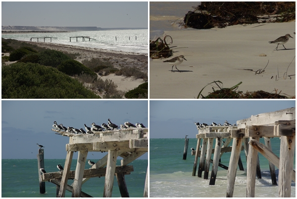
Over the sand dunes from the ruins is the remains of the Eucla jetty, now occupied by a variety of sea birds. The birds had difficulty landing on the jetty in the strong winds.
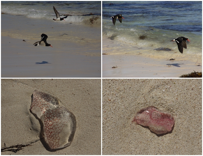
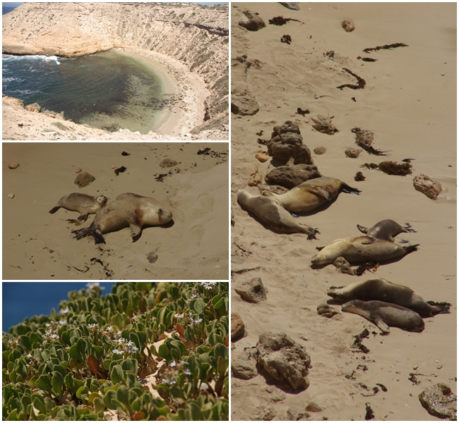
(Clockwise from top left) A few km east of Eucla is the WA/SA border at the Border Village, with its giant Vegemite kangaroo. From here, the Eyre Highway follows the coastline very closely, offering opportunities to view the Bunda Cliffs that soar over the Great Australian Bite. We were able to camp in several locations along the cliffs in 2020, but access to those sites is now forbidden, either for safety or cultural reasons. As the highway tracked inland we stopped overnight at the Whitewell free camp, which really highlights the “treeless plain”, the eastern end of which we reached after a few km the following morning.(clockwise from top left) On our way to the Mexican Hat campground in the Fowlers Bay Conservation Area we passed through the tiny town of Coorabie and the Wookata School site (1919-1939); despite the campsite being deemed unsuitable for caravans we found a suitable site; then took a walk along the windy beach; from which we spotted a large alligator in the headland; red at night – shepherds delight….does that mean a sunny day tomorrow?The following day was gorgeous, so we could enjoy a beach and headland walk beside crystal clear water, free of bees which preferred hanging around Blake.During our beach walks we disturbed a pair of oyster catchers who must have had a nest in the dunes. They made quite a ruckus as they tried to scare us away. Several pieces of colourful jellyfish littered parts of the beach.Within a secluded and protected bay at the base of limestone cliffs, a number (6 adults and 3 pups) of Australian fur seals were sunning themselves on the beach.Our eastbound route (lime green) from Kalgoorlie to Fowlers Bay
Leaving Tambellup, our next major destination is the land of gold, and whilst there we checked out the land of girls!
A journey of close to 700km, there were several routes that we could take. Our preference is usually to take the road less travelled. One way would take us through the town of Hayden, and the iconic Wave Rock, so that’s the route we took. However, we had booked a tour at a location at the eastern end of the Nullabor Plain, about 1,800km away. Would visiting Wave Rock still leave us enough time to get to the eastern end of the Nullabor? A Google search of the Wave Rock website suggested several days at the rock, thus cutting our time to reach the east, and to allow a contingency, meant we visit Wave Rock next time, not to mention that Carol’s shingles wouldn’t allow her to do the walks at the rock.
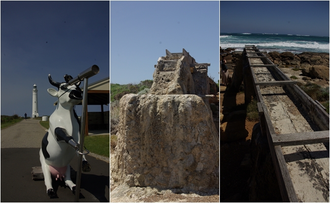
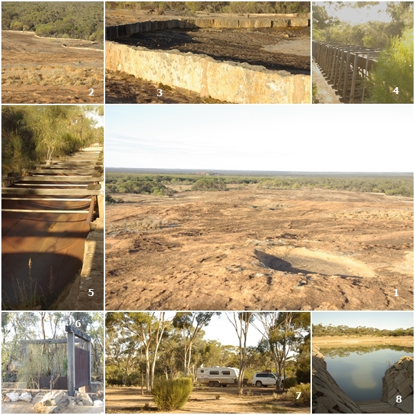
So, on we pressed towards Kalgoorlie, stopping overnight at a lesser know rock, Karalee, and its associated drainage infrastructure. I was fascinated with the aqueduct that was constructed in 1895. More on that below as captions to the photos.
Kalgoorlie-Boulder council had the foresight to extend their 24-hour free camp to a 72-hour free camp, which gives travellers a more realistic timeframe to explore the town, and spend money therein. It was a large site on the edge of town, and always had heaps of vans, meaning it was relatively safe to leave your van there and drive off into town. We took advantage of the three days and feel we explored the town sufficiently. A fascinating piece of Australian history.
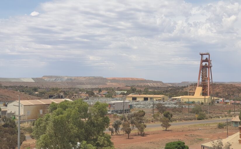
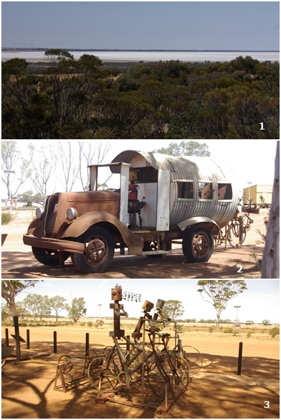
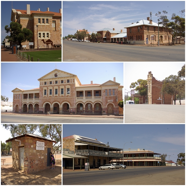
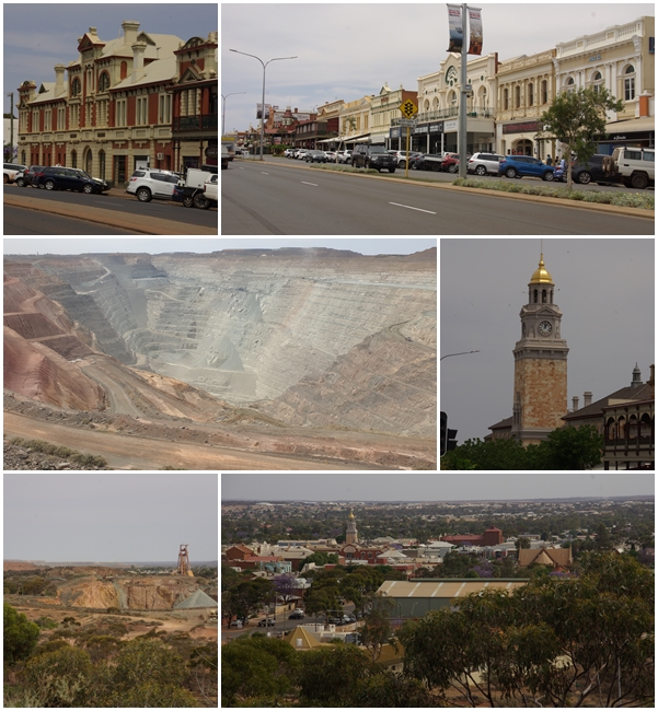
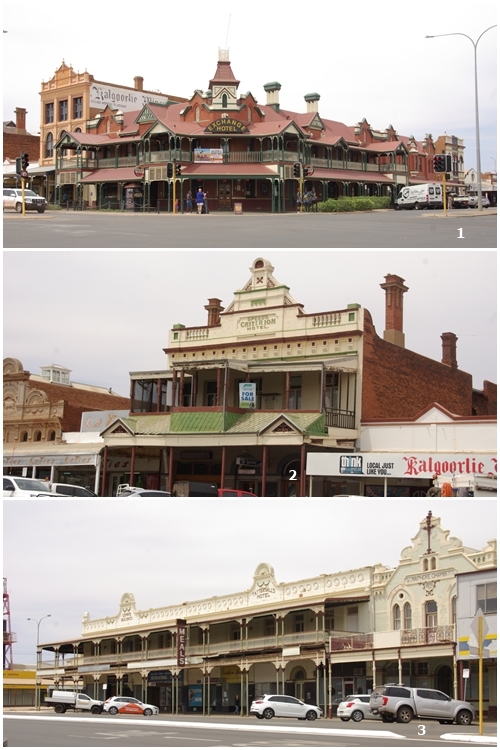
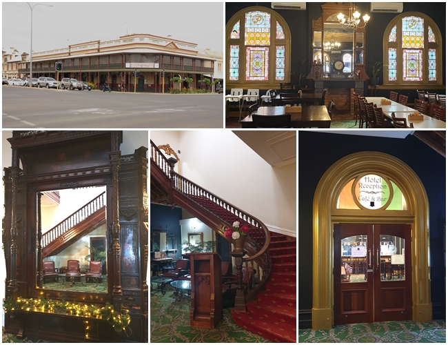
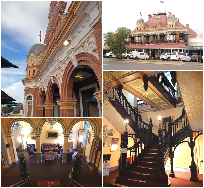
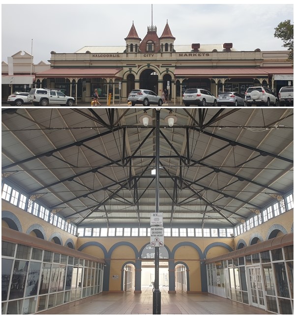
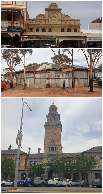
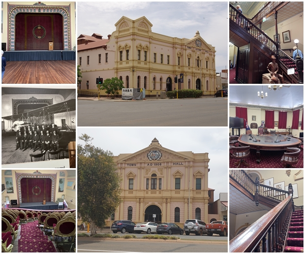
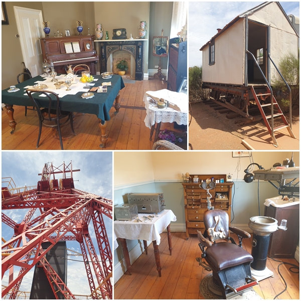
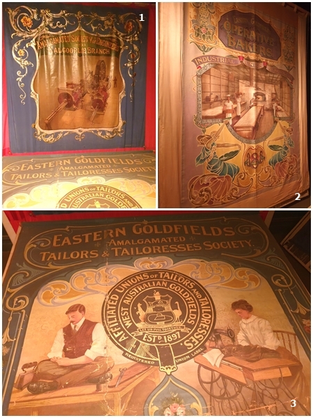
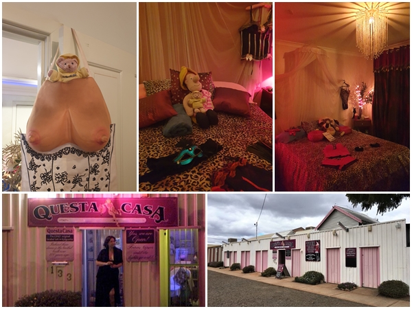
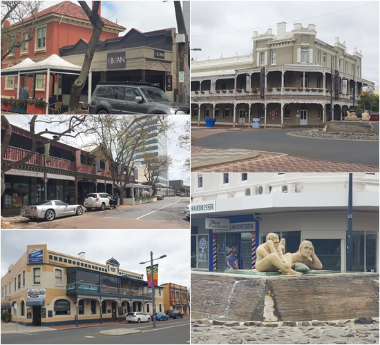
From Tambellup to Kalgoorlie: 1. Lake Grace is both a town and a lake. This is Lake Grace North. The two lakes – Lake Grace North and Lake Grace South – are part of an ancient river system which probably flowed more than 20 million years ago but was reduced to a lake about 5 million years ago and gradual silting made it into the shallow lakes which exist today. As with many inland waterways, the clearing of the land around Lake Grace at the turn of the century has resulted in the whole area experiencing long term salinity problems as the water table rises to the surface bringing dissolved salts with it. 2. Hayden, whilst a very small town, has some creative locals who have created an interesting collection of rural art structures, including this slide-on camper, and 3, a cycle gym class including a whistler.Karalee Rocks: Built in 1895, the Karalee Rocks water catchment system collected rainfall runoff from two large granite rocks (1). Water flowed along a 6km stone perimeter wall (2, 3) and then downhill along a system of cross country flumes and aqueducts (4, 5) to a dam (8) from where it was pumped 3.6km to tanks at the railway station. When the dam was full (48.3 million litres), the gates (6) could be adjusted to redirect the water to the bush. 128 years later we camped at the site (7).In September 1892, gold was discovered in Coolgardie. The ensuing gold rush drew thousands of fortune seekers. By 1898 Coolgardie was the third largest town in WA, after Perth and Fremantle. At its peak there were 15,000 residents plus another 10,000 in the immediate area. By WWI the town was in decline as people moved to Kalgoorlie. Only a handful of the buildings remain, as do the people, with only 1,200 residents.Kalgoorlie is now the major centre of the WA’s goldfields. In June 1893 gold was discovered where the town now stands. This started a gold rush which would eventually lead to the richest gold find in Australian history – the Golden Mile. That find is still one of the world’s largest producers of gold – the KCGM Super Pit. Beautiful historic buildings still remain in the town centre.Some of the remaining buildings are of course the pubs. Only a handful remain from its heyday. (1) The Exchange Hotel is famous for its saloon doors. What I didn’t realise until we dropped in for lunch, is its infamy as a skimpy pub, with the female bar staff dressed in bra and G-string. I enjoyed lunch that day. Two other pubs we passed but didn’t drop in to were (2) Speed’s Criterion Hotel and (3) Tattersall’s Hotel.Another pub we ventured in to for a drink was the Palace Hotel. At the time we could only enter the rear bar and dining area, showcasing beautiful leadlight windows and the main staircase, plus the elaborately carved mirror which stands in the foyer of the hotel. This was a parting gift of mining engineer Herbert Hoover to the Hotel where he spent much of his time when he was in Kalgoorlie. He fell in love with one of the barmaids. Hoover is of Gwalia gold fame, and was to become the 19th American President in 1929.Carol’s favourite pub that we passed was the York Hotel. So we had to stop in there for a drink also. We had heard about its grand internal architecture and staircase. The drinks were cheaper here than at the skimpy Exchange Hotel.Kalgoorlie City Markets building.Top: Even the butchers had elaborate building. This is Moher and Smith Butcher’s establishment. Middle: The two-up shed, 7km out of town. It can only be played there on a Sunday. Minimum bet is $50. Huge amounts of cash were being wagered. Asians were the predominant punters, with rolls of $50 notes in their hands. We couldn’t follow what was going on, so after about 15minutes we left the game. Bottom: The dome of the 1899 Public Buildings is covered in gold leaf.We took a guided tour of the magnificent Town Hall , one of Kalgoorlie-Boulder’s major landmarks. With its grand façade and rich interior decoration, it reflects the town’s immense wealth and civic pride of a community thriving on the 1900’s gold boom. Built as a state-of-the-art theatre in 1908, the Federation Free Classical style building has many beautiful architectural features such as ornate pressed metal ceilings, chandeliers, sweeping staircase, fly tower with original theatre rigging, backstage area with 11 dressing rooms. Costing almost £20,000 ($6m AU today) to construct, the Kalgoorlie Town Hall was officially opened on 8th November 1908.The Museum of the Goldfields showcases the Aboriginal culture and glittering history of the Eastern Goldfields. We took a guided tour through the museum that sits under the relocated Ivanhoe headframe, and contains a vault that contains hundreds of thousands of dollars worth of gold and jewellery, plus displays of heritage rooms in the adjoining 1899 British Arms Hotel, said to be the narrowest pub in the southern hemisphere. Outside are historic cottages and a police wagon that was towed along the railway lines.The Museum of the Goldfields also contains some original hand painted silk banners used by the local trade unions during marches and parades, displayed in a humidity controlled room: 1. The Amalgamated Society of Engineers; 2. Eastern Goldfields Operative Bakers – Industrial Union of Workers; 3. Eastern Goldfields Amalgamated Tailors and Tailoresses Society.Finally, Yum Yum’s favourite guided tour was at the Questa Casa, a historic operational brothel on the infamous Hay Street. Kalgoorlie has always had a reputation not only for its gold but also its girls. With its world famous corrugated-iron “starting stalls”, Questa Casa is the last of the original brothels built during Kalgoorlie’s’ gold-rush era of the 1890’s. Yum Yum enjoyed trying on a shapely apron, and lying on a bed in one of the rooms with a new friend. We saw several rooms, and one used by a dominatrix.
Leaving the magnificent Margaret River region behind we made our way toward the land of the giants, both terrestrial and ocean-going giants.
The first giants to see were the terrestrial giants, majestic forests of towering Karri, Marri, Jarrah and Tingle trees. We meandered through the Southern Forests and Valleys region, passing through the towns of Nannup, Bridgetown, Manjimup, Pemberton and Northcliffe, each with its own distinctive style and character. We dropped into the Visitor Centre at Northcliffe for some helpful information of the area before heading to a bush camp just out of town for an overnighter. A rather disorganised area with camp sites dotted within the forest. We were fortunate to grab a large site which enabled us to stay hitched and we could receive satellite TV despite the proximity of the forest trees.
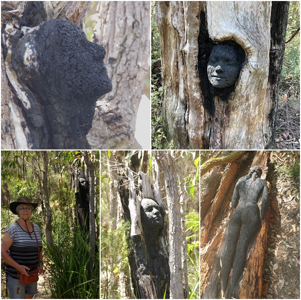
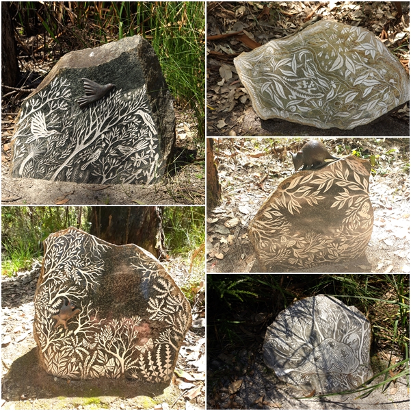
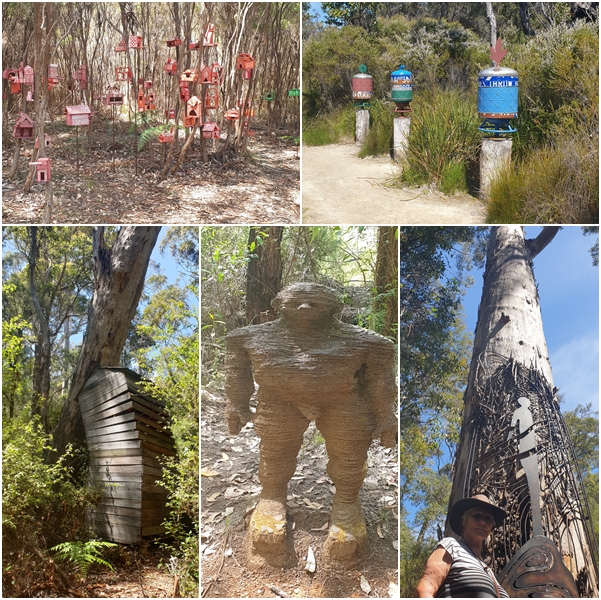
The following morning, we drove to Windy Harbour and Point D’Entrecasteaux. Windy Harbour wasn’t much to look at, just a random array of generally old fishing shacks, with a few more impressive new homes. Despite the nature of the place, the shacks all appeared to be well maintained and tidy, as we drove through the tangle of narrow streets with Blake in tow. Returning to Northcliffe we revisited the Visitor Centre to explore the “Understory Art and Nature Trail” and “Rising from the Ashes” sculptures scattered through several hectares of forest. Absolutely fascinating.
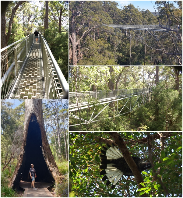
Next stop was the town of Walpole, with the Valley of the Giants and the Tree Top walk, plus the nearby Mount Frankland. Rather than staying in Walpole we opted for a caravan park several km out of town at Peaceful Bay. And peaceful it was. Even the caravan park was peaceful, being more like a freedom camp area with loosely defined huge sites across meandering grassland, rather than the regimented sites of a normal caravan park. We arrived late afternoon, but took a dip in the tranquil clear waters of the Bay after setting up, and the following morning, which was rather cool, but superb nonetheless.
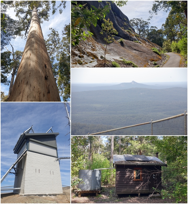
The following day we visited the Valley of the Giants, being a karri, jarrah and tingle forest with a tree top walk along a very high elevated platform. We followed this with a walk through the forest floor, where we bumped into some BOG buddies from the muster, having also bumped into them several days earlier at Augusta. From there it was a forest drive through these magnificent trees to Mount Frankland, and a walk to the top of the rock with its 301 steps to reach the top and the fire watch tower. Carol wisely declined to do the walk.
At the end of this great day, we spent 2 hours, from 4pm to 6pm, sitting in the car outside the Walpole visitors centre where there was internet access so I could participate in a Zoom BOG committee meeting, as I didn’t think there was a sufficient signal at Peaceful Bay.
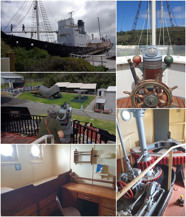
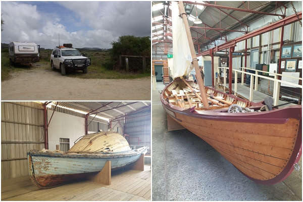
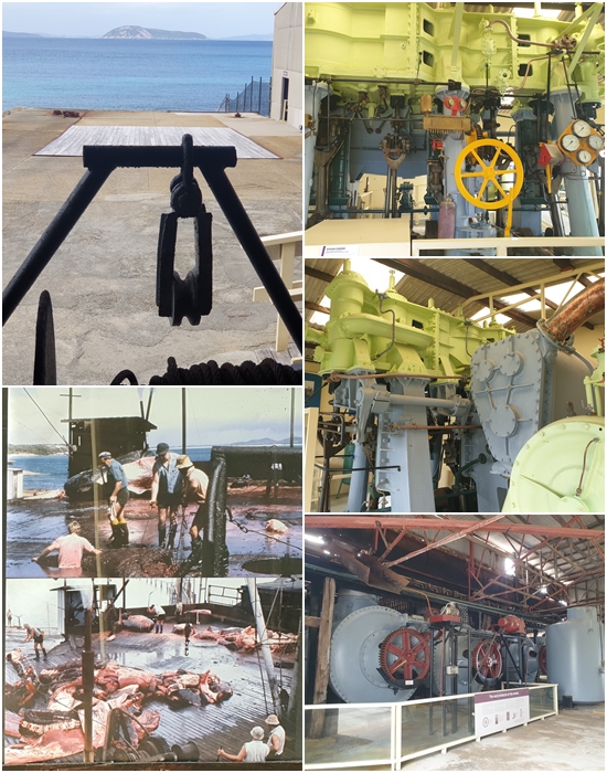
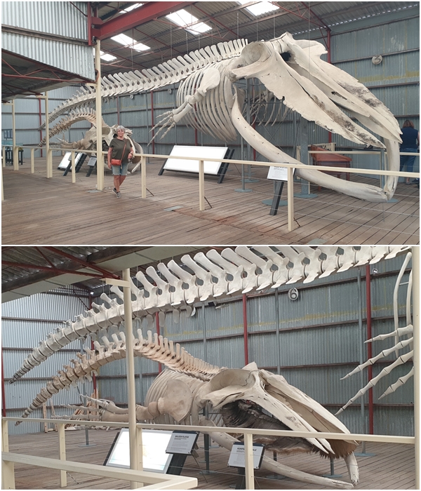
After another peaceful night at Peaceful Bay we headed off to a freedom camp at Cosy Corner, 30km west of Albany. We visited Albany in 2020 and spent several days exploring its coastline and the town but COVID had forced the closure of a few indoor attractions we wanted to see. So we had to return in order to visit the Historic Whaling Station and the National Anzac Centre. We were able to wander the extensive outdoor exhibits at the Anzac Centre in 2020, but not the main building. Both were well worth the return visit. We did the self-guided tour of the whaling station on the afternoon of our arrival which took us 3.5 hours. We could have spent more time there, but domestic activities at Aldi and Dan Murphy beckoned us.
The next day, with Blake in tow we visited the National Anzac Centre for the morning. Over the past couple of days, Carol had been developing a rash and was miraculously able to secure a doctor’s appointment in Albany at two days notice. Carol had a idea what was plaguing her, and the doctor confirmed her diagnosis…..shingles. A course of anti-viral medication and two pain killers were prescribed. At the time of writing (10 days since the doctor’s visit), the irritations exist (not me), but are improving. With medications in hand we headed out of Albany, on our way to Kalgoorlie, stopping overnight at a free camp in the little town of Tambellup, 120km north of Albany.
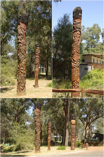
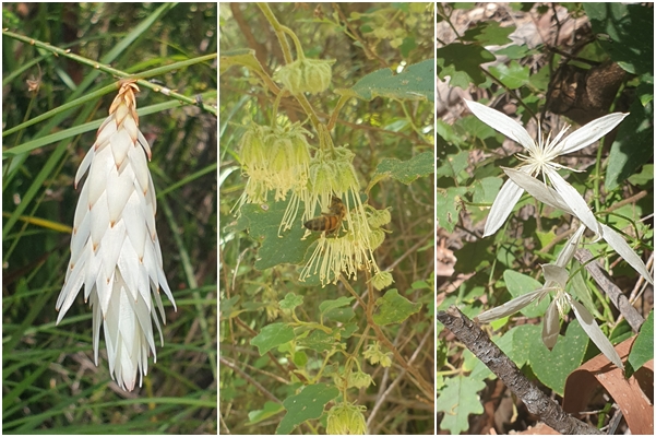
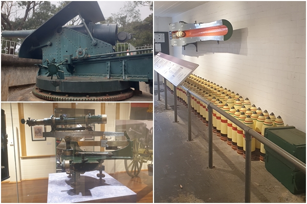
Nannup is a perfectly preserved heritage timber town from the early 1900s, nestled on the banks of the Blackwood River. These beautifully carved totems stand at Foreshore Park on the river’s edge.Nannup’s streetscape. As with many locations in WA’s southwest, there is a connection to the Tasmanian Tiger that roamed here thousands of years ago.The old railway bridge, now a pedestrian/cycle bridge spans the Blackwood River. The river has seen some significant floods, especially the one in 1982. I hadn’t seen the 1982 marker, but Carol was on the bridge and pointed it out to me. That’s more than twice as high as the next highest flood (1946).The town of Bridgetown, also on the Blackwood River, has a lovely streetscape with large trees lining the main street. With a mix of pre and early Federation buildings plus art deco of the 1930s, it’s an interesting town through which to stroll.Our campsite in the Northcliffe Bush Camp. The staff member in the Northcliffe Visitor Centre pointed us in the direction of some nearby wildflowers.Point D’Entrecasteaux adjacent to the seaside town of Windy Harbour has a series of easily accessible vantage points to take in views of the Southern Ocean and interesting limestone features including Nature’s Window (yes, another one). On the Point sits a very low automated navigational light beacon. Certainly not as spectacular as the lighthouses to the west, but undoubtedly, just as functional.Rising from the Ashes. Portraits carved into the charcoal of trees burnt in 2015 within the Understory. These ‘portraits’ of local residents commemorate the catastrophic 2015 Northcliffe bushfire that was out of control for three weeks. Each person depicted was directly affected, including firefighters, those that lost their home, their livelihood, a sense of security. This series acknowledges the trauma of bushfire & celebrates the resilience of community spirit; their tenacity in the face of great adversityThroughout the Understory is this series of five children’s story nooks incorporating sandblasted imagery & bronze elements relating to children’s podcast stories. Each story & sculpture features a local native animal.There were 48 art installations throughout the Understory, so this is just a small sample.Some native flowers within the forest of the Understory.Peaceful Bay, our camp destination for 2 nights whilst we explore Walpole and the surrounding forests.The Tree Top Walk and the ground level Ancient Empire Walk enable access to these giant trees. I was fascinated with the construction of the elevated platform. I think I took more photos of the platform than I did of the trees through which it stands. A white tailed cockatoo flared its tail for me as I walked under it on the Tree Top Walk. The giant tingle trees are shallow rooted and thus have large buttress bases for support. Many have had their centres burnt out from past bushfires, forming at times, large archways.Mount Frankland stands in the centre of the Walpole Wilderness area, offering 360-degree views over the surrounding forest, including the smooth barked karri. A perfect location for fire spotting. In 1956 a fire watch and weather station was built at the top, and the base hut below the summit where the “tower man” ate and slept, walking to the top three times a day. The original fire watch has been replaced, or at least refurbished. The base hut is no longer used.Albany’s Historic Whaling Station, the last whaling station in Australia to cease operations, closing in 1978. Built in Norway in 1948, this whale chaser was launched as W Fearnhead, then sold in 1970 to the Cheynes Beach Whaling Company and renamed the Cheynes IV. It was towed to its present position at the museum in 1981; view from the upper wheelhouse; the rudder mechanism; the Engineer’s quarters; Carol taking aim with the harpoon on a poor defenceless whale.Our campsite at Cosy Corner from where we travelling into Albany: a replica of an original whaling boat; towboat Georgic (1952), used until 1955 to berth whale oil tankers to buoys and running floating pipes from the whaling station.Winching gear used to drag the whales onto the flensing deck to commence processing; the green and grey machine is the triple expansion steam engine removed from the Cheynes III whale chaser; two cookers under the cutting up deck into which chunks of whale were dropped. Each could hold a 40 ton whale. The cookers were heated and rotated, rendering the 40 ton whale to 10 to 11 tons of a thick soupy liquid; old photo of a whale being cut up on the cutting deck and pushed into the holes directly above the boilers.Ocean Giants: A 22m pygmy blue whale, found beached in Albany Harbour in 1973; a 9.5m humpback whale found deceased in the harbour in 2003.The original 6 inch breech loading gun in the A1 gun pit at the Princess Royal Fortress built in 1893 to defend against a Russian threat and protect Australia’s shipping routes; ammunition and a cut-away of the gun in the ammunition bunker; the Depression Range finder used to determine the position and range of targets.The little town of Tambellup, 120 km north of Albany, with its free camp and historic buildings including the railway station and the station master’s house.The lime green line is the 2023 route to date. The blue line is from our 2020 visit to WA, then having to turn back from Albany due to COVID travel restrictions.
With an upper catchment area of just 40 square kilometres, the Margaret River is a rather insignificant waterway of approximately 20km in length. The town of Margaret River is a little more interesting, being a reasonably vibrant tourist town with a shire population of 18,000.
However, the ‘region’ of Margaret River is magnificent. Stretching some 100 kilometres from north to south and about 27 kilometres wide in parts, the region is bounded to the east by the Leeuwin-Naturaliste Ridge, between Cape Naturaliste to the north and Cape Leeuwin in the south, and to the west by the Indian Ocean.
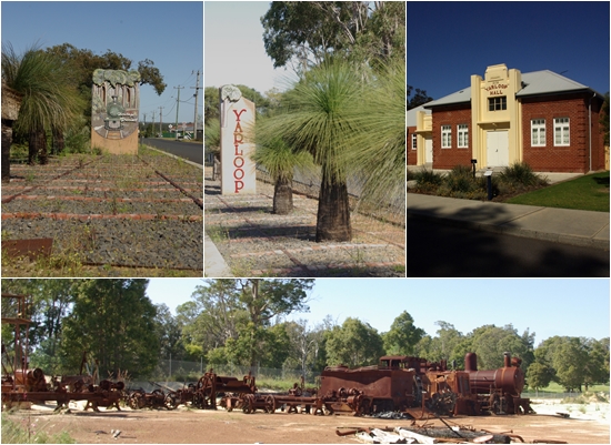
Following our house sit in Perth we headed south along the Kwinana Freeway past Mandurah then the South Western Highway to a farm stay near Yarloop. After two nights and some sightseeing at Lake Brockman, Harvey Dam and the town of Harvey, we continued south, making a quick overnight stop in Capel after a look at the town of Bunbury. Certainly not much to write about Bunbury. Maybe the overcast skies influenced our impression of the place.
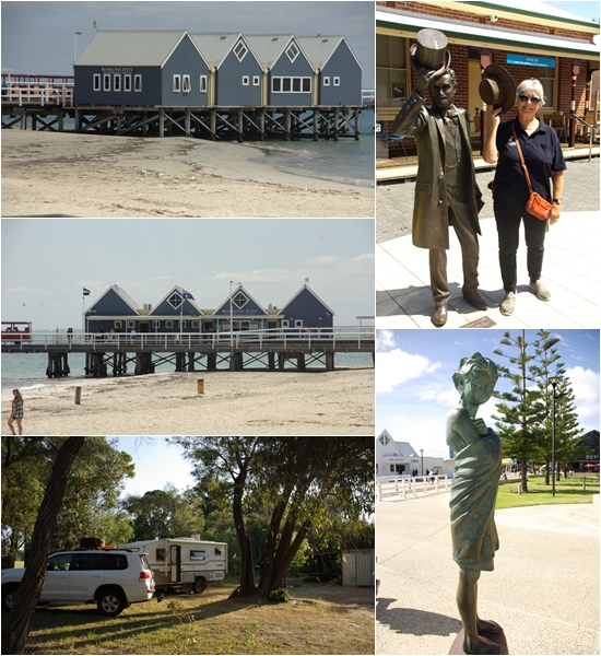
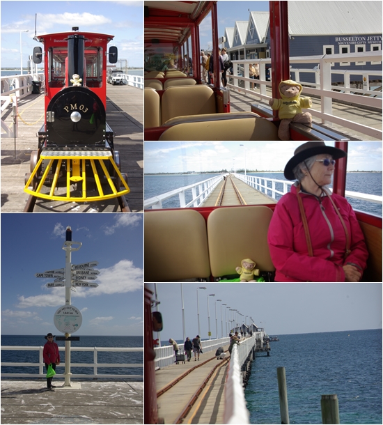
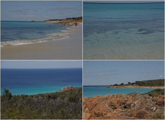
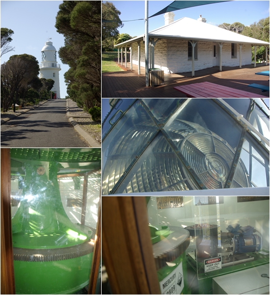
From Capel it was a short 30km drive into Busselton and the start of the Margaret River region. A nice town with a lovely foreshore and the famous Busselton wharf. First stop, the Visitor Information Centre for a list of the must-sees. We were given the low down on the entire region. We found a farm stay, set up the van, then headed out for the remainder of the day following the coast to Cape Naturaliste, swimming at Meelup Beach on the way and touring the lighthouse at the Cape. The following day we returned into town, with Blake in tow, to ride the Jetty train, too far for Yum Yum to walk, as the jetty is 1.8km long.
We left Busselton after morning tea at The Goose café. To reach our next farm stay near the township of Margaret River we headed west again to Dunsborough to take Caves Road to the south, then stopped in at a quirky little town called Cowaraup (Cowtown to the locals), before arriving at the Olive Hill Farm for three nights.
The Margaret River region is famous for its wine, caves and the Margaret River Surf Classic. So we partook of all three on the following day…..well, nearly. First, a fabulous guided cave tour at Lake Cave. Then out to Prevelly on the coast, the location of the Surf Classic. A windy day and messy surf. Only one board rider was out there. We enjoyed a superb coffee at the White Elephant Café as we watched the surfer, followed by two cellar door tastings, one at Cape Grace Wines, the second at Jarvis Estate. The owner of Cape Grace, Karen, was wonderful, as were her wines. The owner and the wines at Jervis Estate, less so.
The following day saw us head to Mammoth Cave for a self-guided tour followed by morning tea at The Shed in Witchcliffe. Such an amazing establishment with heaps of old stuff making the café very interesting and quirky. There was also a bookshop, wine store and a providore of smelly stuff, and a bar was being created, all surrounded by a collection of old wares that have taken years to collect. Oh, and the coffee was the best I’ve tasted so far in WA. We bought some books, and a few bits of old stuff at a nearby second hand store. Then a short drive to the Settlers Tavern in Margaret River for lunch. We walked some of our lunch off on a 2.5km river walk in the town.
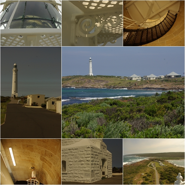
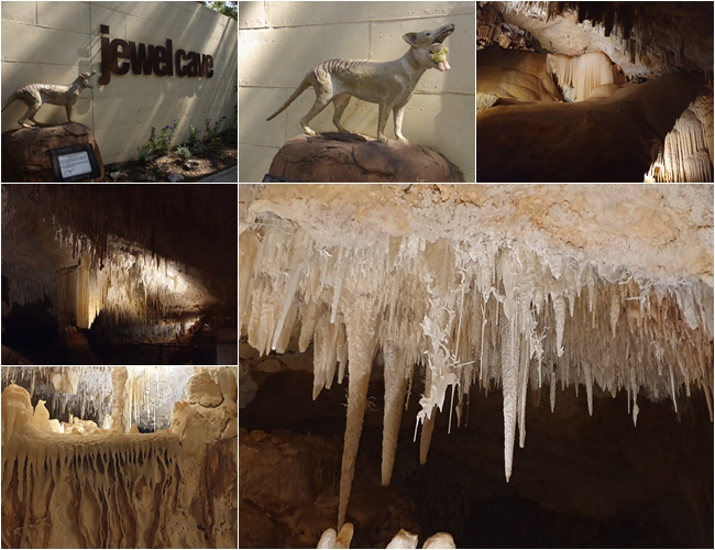
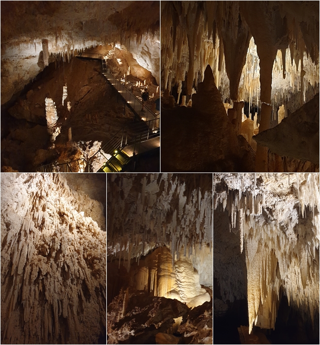
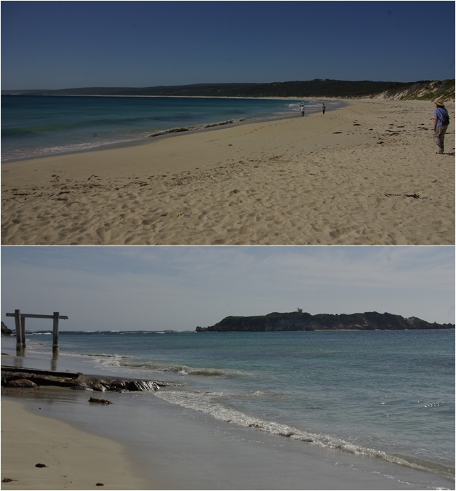
We packed up the following morning for a short 60km drive to Flinders Bay caravan park in Augusta at the southern end of this magnificent region. A short walk to a swimming location, with reasonable water temperature, I had a dip, though Carol declined. The next day we visited the Cape Leeuwin lighthouse for a tour. I was the only participant….lucky me. A beautiful lighthouse, with a fascinating museum in one of the restored lighthouse keepers cottages. This was followed by a guided tour of the nearby Jewel Cave, then to Hamelin Bay in the hope of seeing inquisitive sting rays. Unfortunately they must have had somewhere else to be that day. Worst of all I didn’t have my swimmers with me so I had to forgo a swim in the beautiful waters of the bay.
Our first camp after Perth was at Jenny’s Farm Stay near Yarloop. A 100 acre property with a few head of cattle and a wonderful border collie named Blue. Jenny allows fully self contained caravanners over 60 years of age to stay for a modest fee.Yarloop is a tiny, and tidy, town with a significant rail heritage. It appears that some attempts have been made to create a rail heritage precinct, but to no avail.South of Yarloop is the town of Harvey and the historic Sterling House with its beautiful gardens, and a café from which we surveyed the garden. Har Ve cheese has cattle that take the term ‘long horn” to new heights (or lengths). An alien spaceship landed in Harvey Dam.Bunbury streetscapesBunbury’ Dolphin Discovery Centre; a model of the French explorer Nicolas Baudin’s’ ship, Le Geographe in the Bunbury Heritage Centre and the view from the Marlston Hill lookout to the Bunbury lighthouse.As we were leaving Bunbury a pair of kite riders treated us to a spectacle as they raced up and back along the coast in front of our vantage point. Our free camp at Capel and the little Anglican Church in Capel.The famous Busselton Jetty; Carol tips her hat with John Garrett Bussell, the first settler in the area in the early 1830s; the Fish statue at the Jetty; our overnight farm stay near Busselton.Busselton Jetty train ride. Yum Yum being the daredevil, riding on the engine, and travelling with his arm out of the window, He’s such a risk taker. Carol told him to come inside, sit down and behave. So he did.Meelup Beach and others near Cape Naturaliste.
;
Cape Naturaliste Lighthouse: The revolving 3.5 tonne light prism structure floats on a mercury bath, making for an almost frictionless rotation. Once driven by a series of pulleys and heavy weights, much like the winding mechanism of a grandfather clock, it is now driven by a small electric motor.
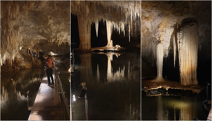
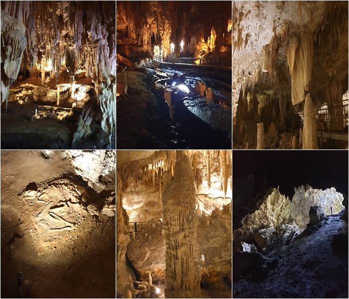
The town of Cowaramup (aka Cowtown) with its cow themed street art.The Laurance Winery (now Cherubino) erected a statue modelled on the owner, Dianne Laurance, in the lake at the front of their winery. The locals refer to it as the Chick on a Stick. The cheeky townspeople of Cowtown, not to be outdone, erected a suitably themed statue in their main park, affectionately known as the Roast on a Post, or the Rump on a Stump. (the Chick on a Stick photo is courtesy of Laurance Wines. Used without permission)The Olive Trees Farm near Margaret River. Large sites, separated from one another by two or three rows of olive trees. The owners no longer harvest the olives, but they do run a few head of sheep. There is lovely walk to a creek nearby.The White Elephant Café at Prevelly; the Bussell Hwy as it passes through the middle of Margaret River; Surfers Point at Prevelly; Barrett Street weir on the Margaret River walk; Cape Grace Wines.Lake Cave. The broad “table” is suspended above the level of the water, held up by the column above.Lake Cave.Mammoth Cave. Not as picturesque as Lake Cave, probably due to reduced lighting in Mammoth, which is self-guided. It is however, equally stunning.
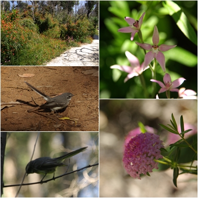
Mammoth Cave was a one-way route, so upon exiting the cave we had to walk back to the start above ground along a path through the forest, enabling us to enjoy wildflowers and wildlife.
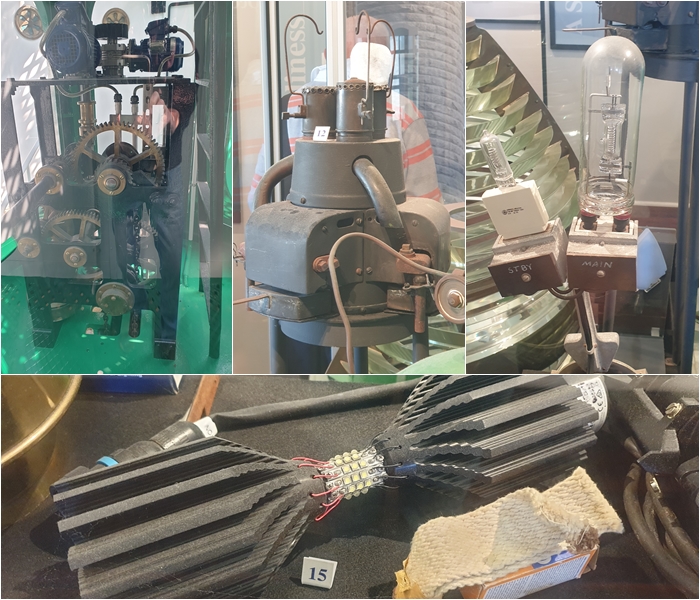
“The Shed” in Witchcliffe. A recently opened multi-outlet store containing a cafe, bookshop, wine cellar door, art space, smelly stuff providore and a soon to be opened bar. It has been years in the making with the collection of interesting and quirky artefacts and implements from around the region.Augusta: our campsite at Flinders Bay; the swimming beach; an unusual house, possibly from the 1930s that looks like two vintage caravans.Cape Leeuwin Lighthouse. This has recently been beautifully restored. A long climb to the top left me a little breathless, but it was worth it, not just for the view, but to use the beautiful stairway and marvel at the stonework built in 1895. This is where the Southern and Indian Oceans meet.Cape Leeuwin Lighthouse: the present mechanism to rotate the light prisms which, like at Cape Naturaliste, float on a mercury bath; the second light source to be installed was a kerosene mantle, introduced in 1908. In 1925 the cluster of three mantles was installed. These were replaced by tungsten halogen lamps in 1982 until 2017 when LED bulbs were introduced.Built in 1895, this water wheel at Cape Leeuwin was used to pump water to the lighthouse for its construction and later to the lighthouse keepers cottages. Water was supplied to the wheel by a natural spring. No longer required to supply water, an electric pump delivers water to the wheel from time to time to keep it moist to prevent it drying out and cracking, despite it now being covered with calcified lime. As for the pirate cow…..well, someone had a sense of humour.Jewel Cave; Yum Yum went to pat the thylacine, and was almost devoured. This cave has guided tours and, like the others, is spectacular.Jewel CaveHamelin Bay. Unfortunately no stingrays ventured close to shore whilst we were there.
We left Nambung National Park and the Pinnacles late morning and made our way towards Perth. We still had three days before our house sit was due to commence so we were invited by some new friends we met at the Muster, John and Sue, to spend a few days with them at their home in Guildford, north east of the city in the Swan Valley.
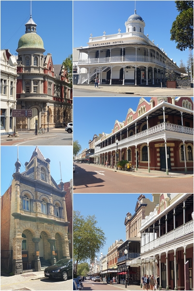
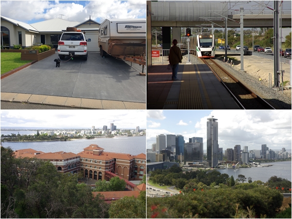
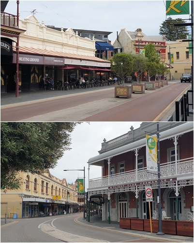
We set up the van on their property and then went for a walk through the historic township. The following Monday we had a meeting with the owners of the house sit, 40km to the south where we met Jack, a 14 year old cavoodle, who was to be our companion during the house sit. We dropped into Fremantle on our way back to Guildford for brunch and a look around. Having lived and worked in and near Fremantle for three months at the end of 1999, I was keen to see if I recognised much of it. Obviously the old historic buildings hadn’t changed, though there seemed to be more of them than I remember, however the area surrounding Fremantle was totally different. Twenty three years of development has seen houses and shopping centres pop up where there were once farms.
On our last day with John and Sue they took us on a brief tour of some of the wineries in the Swan Valley, which was a very relaxing and enjoyable afternoon. With them having owned a hire car business for thirteen years in Guildford they knew the pick of the wineries. Pre-dinner drinks (as if we needed any) in the newly restored historic Guildford hotel, followed by steak burgers at Guildford’s iconic Alfred’s Kitchen saw a wonderful three days with John and Sue draw to an end. Unfortunately I was remiss by not taking many photos of Guildford or the Swan Valley.
Once the Shorte family headed off on their holiday mid-morning on Wednesday, we parked the van on the driveway and set ourselves up in the house. Fortunately we are able to sleep in the house which does make things easier, though we are constantly going in and out to retrieve bits and pieces.
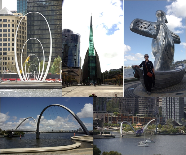
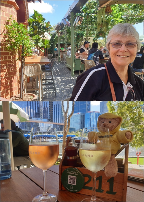
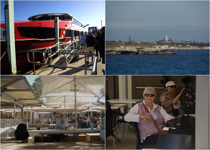
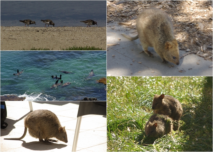
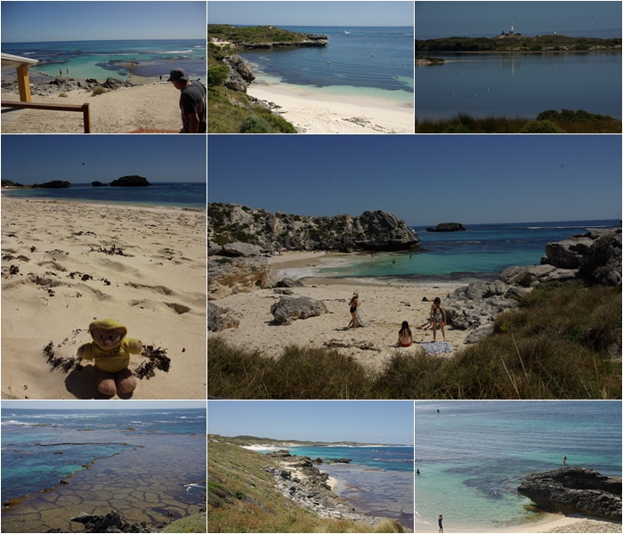
In addition to walking Jack every day, we headed out on most days to explore Perth and its environs. Day trips included a train ride to Perth city to visit Kings Park and the Botanic Garden then in to Elizabeth Quay. Another had us drive south to Mandurah to have lunch with friends Matt and Renee who we met at the Muster. Living in a canal estate, Matt and Renee took us on their pontoon boat to one of the waterside restaurants. On the way a small pod of dolphins swam along with us. Although I didn’t take my camera, I did have my phone, but I was enjoying the company and surroundings so much that I didn’t take one photo. Another day was spent on Rottnest Island. Unfortunately it was only one day. John and Sue had recommended we spend at least one night on the island, but alas, we didn’t. We’ll certainly do that next time we visit, probably two nights. We rented a couple of push bikes to get around the island. More time would allow some swimming and snorkelling and visiting all the little bays and beaches the Island has to offer.
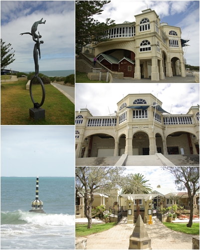
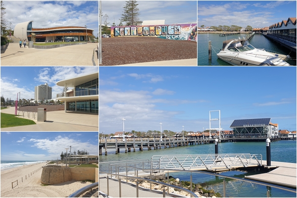
Another day was to visit the Sunset Coast which spans more than 50km “boasting nineteen white sand beaches that leave those looking for surf, sun and endless sand spoilt for choice”, or so the tourist guide states. Starting at Cottesloe Beach southwest of Perth, it ends at Two Rocks in the north.
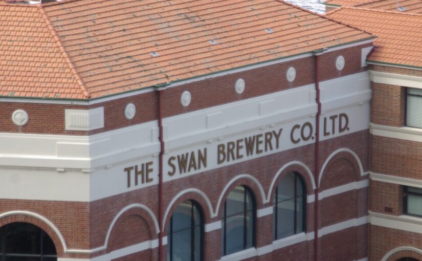
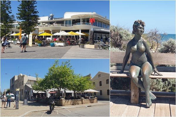
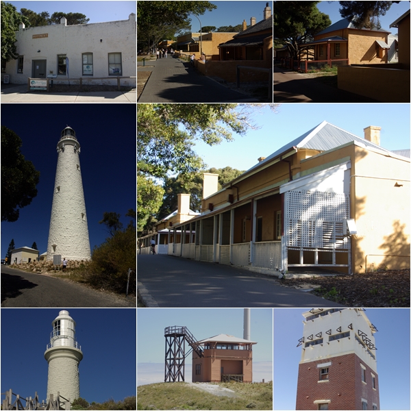
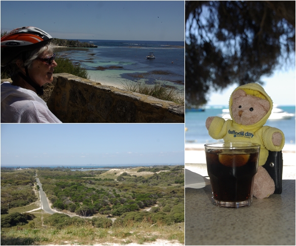
The only photographic evidence of our stay with John and Sue in Guildford. They sold the hire car business a few years ago, but have kept a rare original 3.5 litre Jaguar drophead coupe.Some of Fremantle’s historic buildings.More modern additions to the Freo streetscape include Bathers restaurant at Bathers Beach; a bather at Bathers Beach and the Bistrot Café, our brunch venue.Clockwise from top left: our house for 9 days over the school holidays, with Henrietta holding on to Jack while I took the photo; catching the train into Perth; Perth skyline from the State War Memorial in Kings Park; The Swan Brewery Company building (1879). Redeveloped in the 1990s as apartments, restaurant and conference facilities.Elizabeth Quay precinct: Spanda, an 8 storey, $1.3 million sculpture; The Bell Tower; First Contact Sculpture – a representation of what the local indigenous Noongar people saw of the tall ships as their past ancestors returning from the sea; Elizabeth Quay pedestrian bridge.Lunch at The Island restaurant and bar, Elizabeth Quay.Kings Park and the Western Australian Botanic Garden.On our way to Cottesloe Beach and the Sunset Coast we dropped into Fremantle again as I wanted to revisit the Cappuccino Strip (aka South Terrace). When working in Perth in 1999, I cycled with a large group each weekend, stopping for a coffee in Freo, and again in Perth. The Freo cappuccino strip these days is a far cry from what I remember 23 years ago, where cafes competed against each other to produce the best coffee. Gino’s Café (top photo), now 40 years in business, was disappointing. The coffee was ordinary and the staff abrupt. And there didn’t appear to be much competition along the Strip.Cottesloe Beach and its pavilion. Cottesloe was looking rather tired. Scarborough Beach and Hillarys Boat Harbour north of Scarborough along the Sunset Coast were considerably more vibrant than Cottesloe.Day trip to Rottnest Island (clockwise from top left): Boarding our ferry at Shed B in Fremantle; approaching the Island; morning tea at Geordie’s Café; lunch at Hotel Rottnest.Rottnest wildlife including plovers (?), long nosed fur seals and the iconic quokkas of Rottnest.Various beaches around the island and one of the inland salt lakes (top right). Historical building around Rottnest including various accommodation types, the Battery Observation Post (1938), a signal station (1939) call sign “Bowerbird”, Bathurst Lighthouse (1900) and Rottnest Lighthouse (the taller one) (1896).A rest stop on our cycle circumnavigation of the island; after cycling 22 km, Yum Yum was ready for a bourbon and coke at the hotel; the view to the mainland and Perth from the Rottnest Lighthouse.
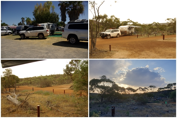
The Muster is over and most of the attendees have departed. After bidding farewell to the few remaining committee members, we headed off, firstly south to Geraldton to have our awning replaced, then north, past Horrocks, to Kalbarri and the Kalbarri National Park. We decided to stay 3 nights at a Kalbarri caravan Park, rather than free camping, in order to get our clothes washing done. Not quite the relaxing destination I was craving following the muster, but the chores need to be done.
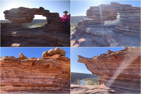
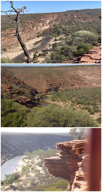
Our two full days were spent exploring the National Park, firstly the inland gorges and then the seascape. We enjoyed the terrific landscapes but soon tired of the inland heat and the coastal winds, not to mention tiring of being cooped up in a caravan park.
School holidays are fast approaching, which will clash with our time in Perth. Time to find a house sit in Perth. We had success with a sit in Success (strange name for a suburb). Although we were relatively close to Perth, there was still some areas we wanted to explore before getting there, especially the wildflowers.
We set an itinerary that includes some of the iconic wildflower locations in the greater Geraldton region and headed off. Due to an extremely dry year so far, the wildflowers were disappointingly scarce. Expecting to see thick blankets of wildflowers covering parts of the landscape, there were just thin sparse pockets of them. Nevertheless we stopped regularly, where the road shoulders allowed, to take photos of what we found.
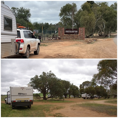
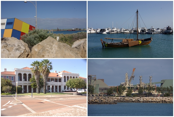
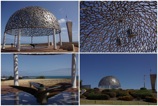
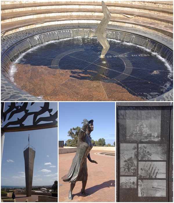
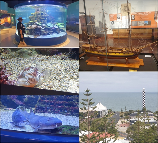
With the Muster behind us, we passed through the nearby town of Northampton on our way to Geraldton, then stopping overnight at the Fig Tree Crossing rest area, 15km north of Geraldton. By the time we arrived there were already 3 vans from the Muster, with a further 2 pulling in after us. A veritable mini-muster.Whilst waiting for the awning to be replaced on Blake, we wandered the streets of Geraldton, walking the foreshore and past the Geraldton Courthouse.On the 19th November 1941, after leaving Geraldton 4 weeks earlier, HMAS Sydney encountered the German Raider HSK Kromoran off the WA coast and became involved in an engagement leading to the loss of both ships. No trace was found of the HMAS Sydney or the 645 seamen on board.On Sunday 16 March 2008, HMAS Sydney was found at a depth of 2,480 metres, 207km west of Steep Point WA. The gull in the Pool of Remembrance indicates that location, whilst a sailor’s mother continues to look out to sea in the hope of the ship returning.We collected Blake at about noon, and headed back up north to Kalbarri National Park. Reasonably early on the following morning we visited Natures Window before the arrival of tourists, with views over the Murchison River (no, we’re not tourists, we’re grey nomads).
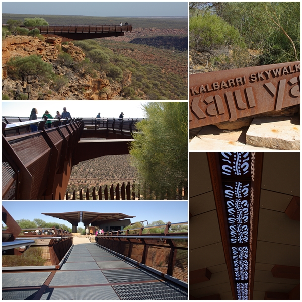
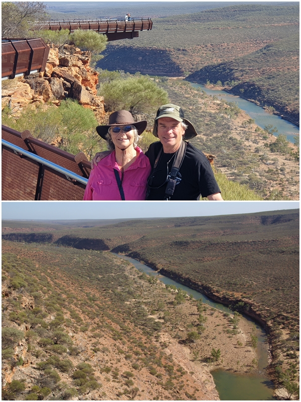
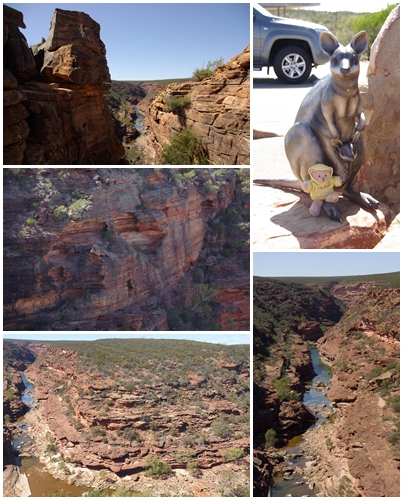
Around the information area of the Skywalk are bronze critters including a western quoll, a Kalbarria brimellae (extinct), a eurypterid (extinct), a Peregrine falcon (not extinct) and an emu family (definitely not extinct)Kalbarri National Park’s Skywalk, an amazing and obviously very expensive piece of infrastructure, with two walkways cantilevering 17m and 25m from the cliff face, overlooking the Murchison River.
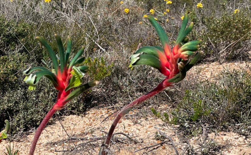
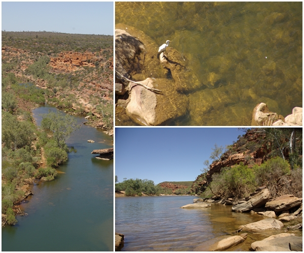
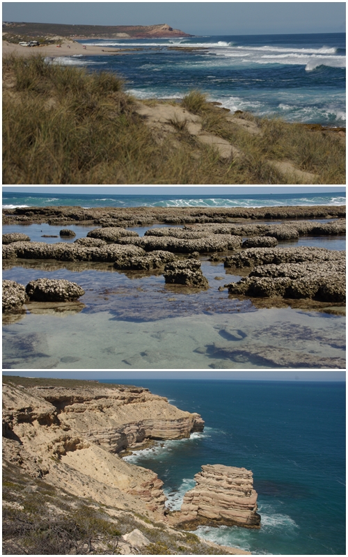
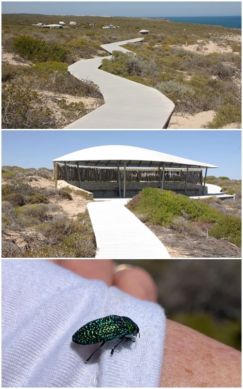
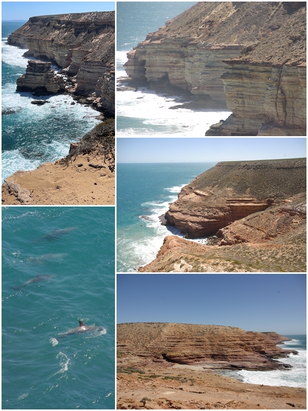
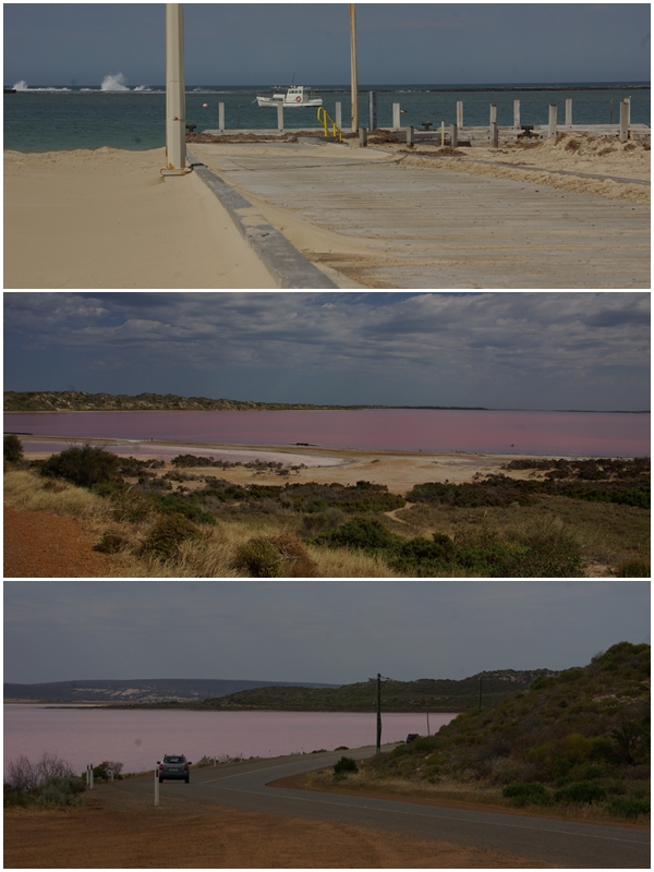
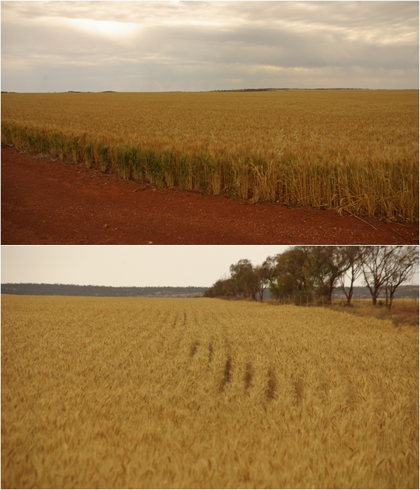
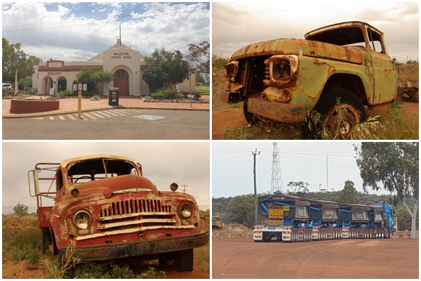
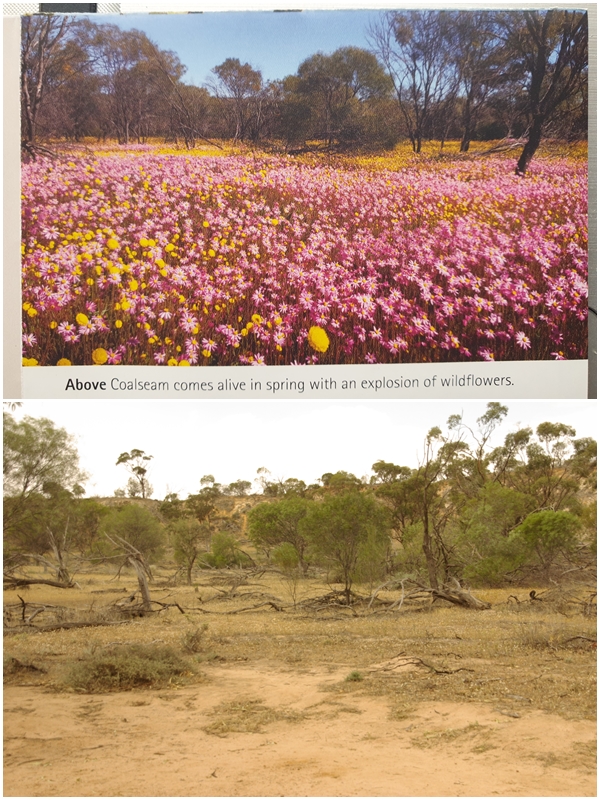
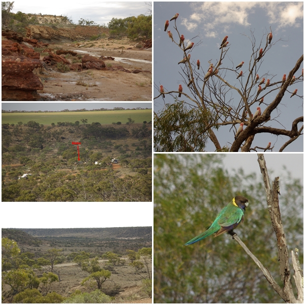
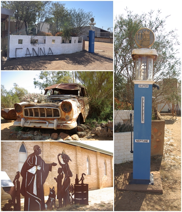
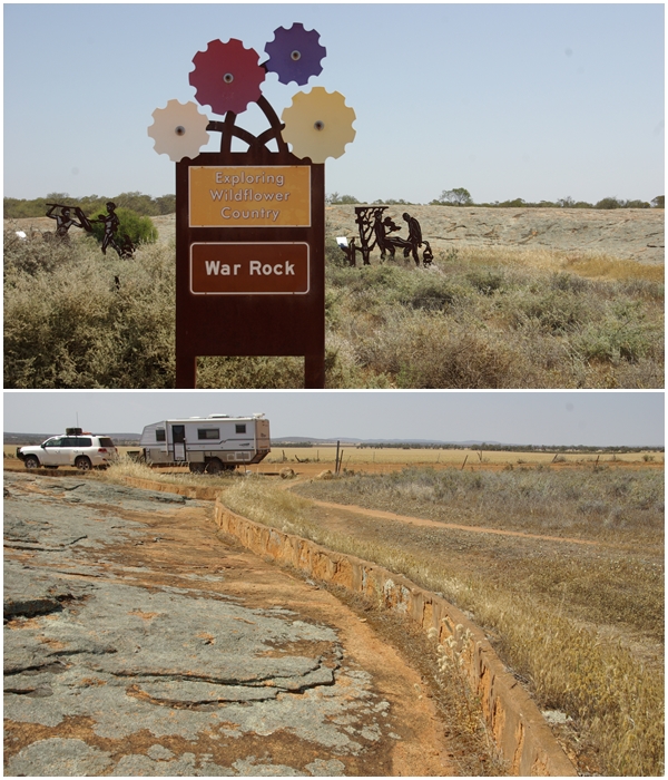
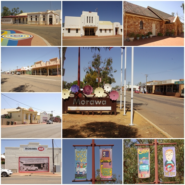
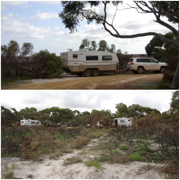
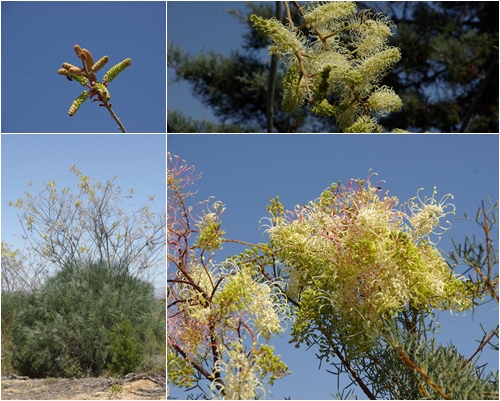
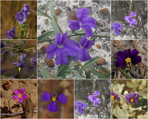
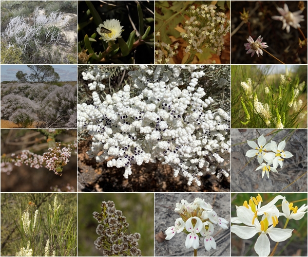
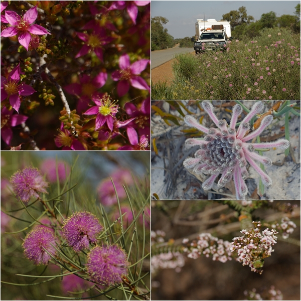
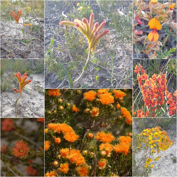
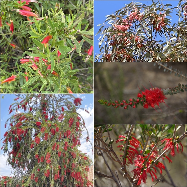
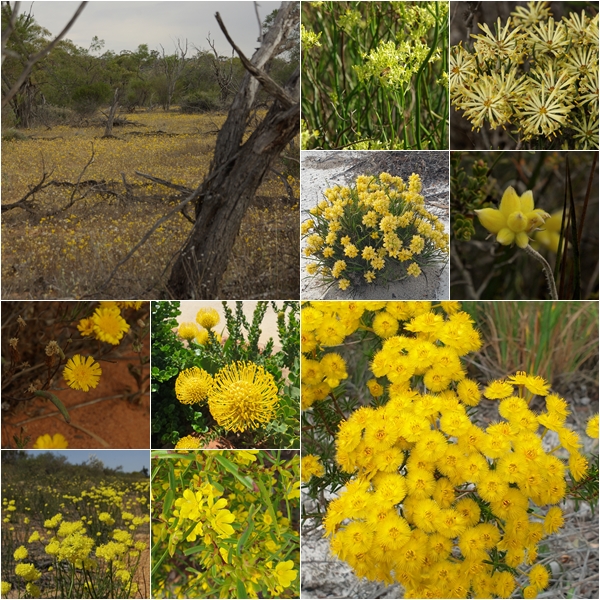
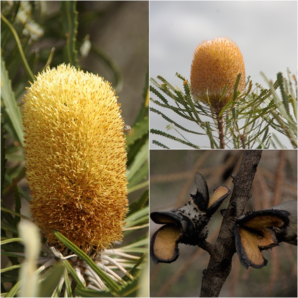
Views of the Murchison River from the Z Bend lookout. Yum Yum met a black-flanked rock wallaby at the track head.30km south of the Skywalk is the Ross Graham River Trail, with access to the Murchison RiverWhilst at Kabarri we stayed three nights at the Murchison Caravan Park. It was a wonderful relief to to move on to the Miners Camp in the Coalseam Conservation Park with its spacious sites and views from the balcony. Unfortunately we spent only one night at Miners.The Kalbarri NP reaches the coast, encapsulating some wonderful coastal scenery. Red Bluff, Blue Holes and Island Rock are pictured.A boardwalk links Island Rock and Natural Bridge. One of two jewel beetles that hitched a ride on my shirt along the boardwalk.Views near Island Rock and Pot Alley. A small pod of dolphins cruised along the coast.Between Kalbarri and Northampton is the old port town of Gregory and the adjoining pink Hutt Lagoon. The pink hue is due to the presence of the carotenoid- producing algae, Dunaliella salina, a source of beta-carotene. Unfortunately the cloud cover didn’t allow the lagoon to look its best.Wheat is the most significant crop in the region, together with canola and lentils.Our journey inland in the hope of finding wildflowers took us through the town of Mullewa, with some old trucks on display and a wheely long road train, with 28 axles.Coalseam Nature Reserve is renowned for its wildflower displays, as evidence by their brochure. Unfortunately the dry year has led to bare earth in much of the campground area.Whilst at Coalseam I did the plateau loop walk with views down to the surrounding countryside, and our campsite (Blake is arrowed). Flocks of galahs and white cockatoos frequented the area and a few ring-necked parrots were up on the plateau.The little town of Canna, with its delightful free camp and interesting history would also normally be a wildflower mecca.War Rock, near the town of Pintharuka, was thought to be the site of an aboriginal tribal conflict. In 1936 a small wall was built around its perimeter to capture rainwater and channel it to Pintharuka Dam.Morawa is a small but proud town with a nice streetscape and numerous quirky and humorous road safety banners lining the street.Before returning to the coast between Geraldton and Perth we stopped for two nights in the Badgingarra National Park where we found another BOGGER from the Muster. An afternoon walk into the park revealed a nice assortment of wildflowers.A prolific wildflower along many of the inland roads is the Prickly Plume Grevillea. The flower spikes protrude from the nicely rounded main bush, starting as closed flower buds that then open into cream, then red, blooms.Now to get technical, these flowers are within the genus “purple”. Well, that’s how I’ve grouped the following images.Genus “white”. I do know that the central photo is of a Conospermum unilaterale.Genus “purple”.Genus “orange”, including kangaroo paw.Genus “red” including weeping bottlebrush.Genus “yellow”, with a thin carpet of daisies on the top of the plateau at Coalseam Conservation Park.Two varieties of Banksia and open seed pods following a fire.
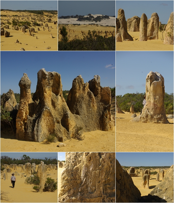
Our final stop before reaching Perth was the Pinnacles in the Nambung National Park, on the coast, 22km south of Cervantes. Several theories exist as to the formation of the pinnacles. Both involve the calcification of trees.
Monday 4th September to Sunday 17th September 2023
We and the rest of the Bushtracker Owners Group committee arrived at the Muster site, Horrocks Beach, 3 days prior to the arrival of the hoards. That gave us plenty of time to set out the caravan sites on the oval, inspect all the available facilities, being a beautiful community centre and an old pavilion, both of which would hold activities every day over the course of the 10-day muster.
As muster coordinator, I didn’t have much free time to take photos of the festivities, though I did manage to snap off a few, and I borrowed some from friends.
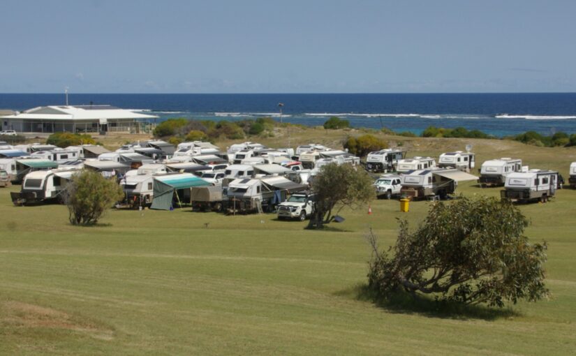
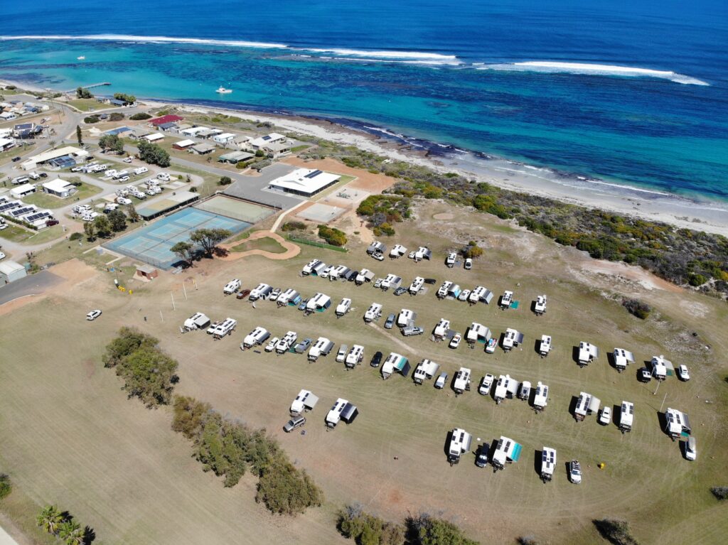
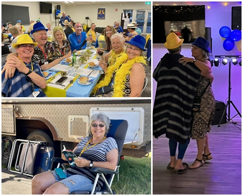
We had 119 members in attendance, with 48 vans camped on the Horrocks Oval, 11 vans in the adjoining Horrocks Caravan Park, and a further 3 couples in cabins. Whilst tiring, the entire event was an absolute hoot. We had near perfect weather with the exception of 24 hours over which we had winds and rain lash the coast with gusts up to 100 kph. I announced at happy hour for 3 nights leading up to the severe weather event that it was coming, giving plenty of notice for everyone to pull in their awnings and annexes before they blew out to sea. The timing of the event coincided with our seafood lunch so most of us were securely holed up in the community centre enjoying an outstanding seafood meal.
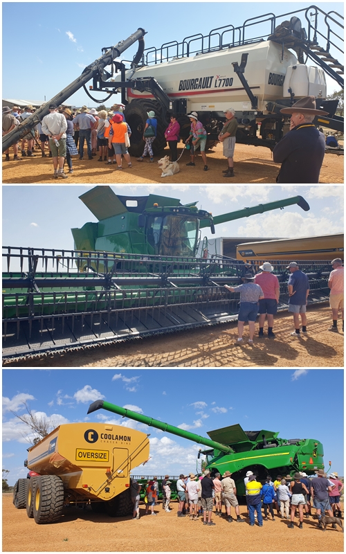
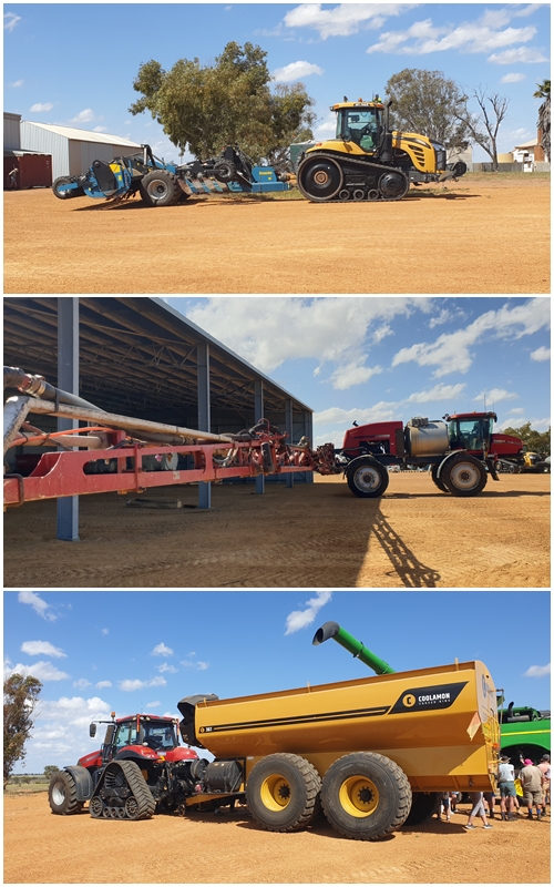
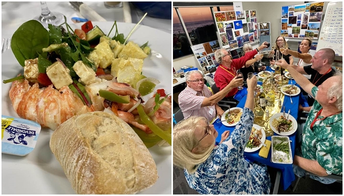
Other fun stuff that happened over the muster included a wildflower tour, a farm tour, spit roast dinner, camp oven cook-off, trivia night, bingo night, big onsite breakfast and a themed (blue/gold/beach) fancy dress catered dinner. In addition there were workshops on maintenance, Starlink and 4WD recovery, a book chat, a presentation on Cyclone Seroja that impacted the region in April 2021, trips to the Northampton Machinery Museum and the Northampton Art and Crafts Gallery, plus happy hour around communal camp fires nearly every night. All interspersed with auctions and raffles (Carol was the raffle ticket seller and raised $2,000). We also held our AGM at which I was re-elected again as vice president. There were 8 nominations for the 8 committee positions, so no voting was required.
With the Muster behind us we can now enjoy a more relaxing time as we explore Western Australia’s southwest.
Horrocks is located below an escarpment with a steep slope leading down to the town. Expecting a long line of vans to appear at 9am, as is usual, we set up the meeting and sign-in location at the top of the esparpment. The most vans we had at any one time was 4, so all could have been done at the oval. Everyone was easily positioned on their allocated sites.46 vans occupying the Horrocks Oval (credit Stephen Ringe). The Community Centre is the large white roofed building.Some the farm implements used on the nearby Wepowie farm that is owned by one of our couples in the club.
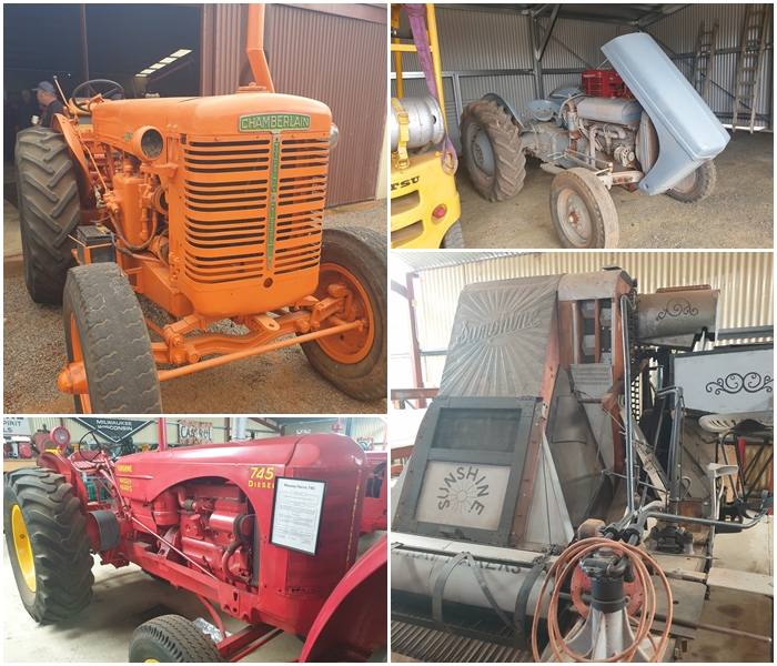
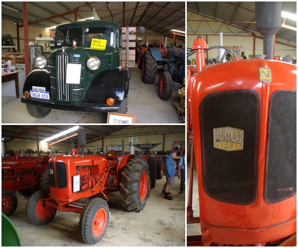
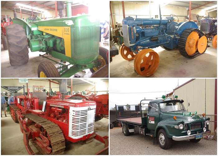
Historic farm implements at the Northampton Machinery Museum, including an Aussie made Chamberlain tractor (the orange one). Compare the Sunshine harvester to the big green and yellow John Deer combine harvester in the previous photos.A few British items, a 1949 Austin 5t truck and a BMC tractor.
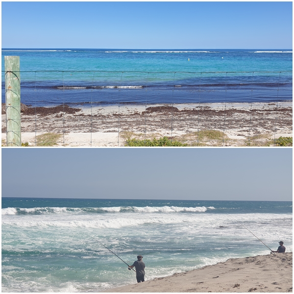
Our fun table at the seafood lunch (credit: Lesley McDonald)Our table at the catered dinner; Carol and I pressing the boards (dancing in thongs is a bugger); Carol relaxing during some free time. (credit: Lesley McDonald)Horrocks Beach and a fisherman a little south at the mouth of the Bowes River, both visited when we had some down time

 Over the sand dunes from the ruins is the remains of the Eucla jetty, now occupied by a variety of sea birds. The birds had difficulty landing on the jetty in the strong winds.
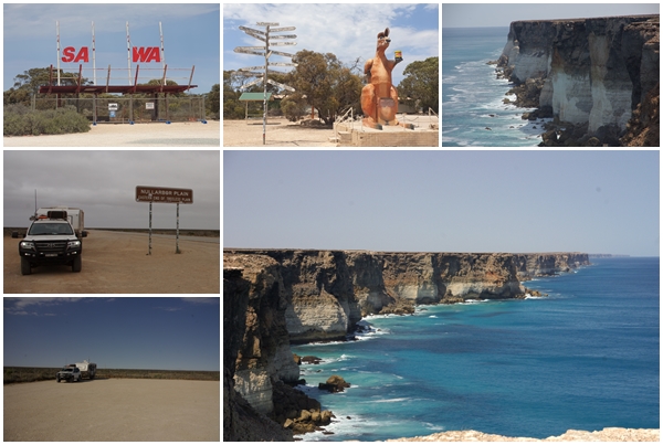
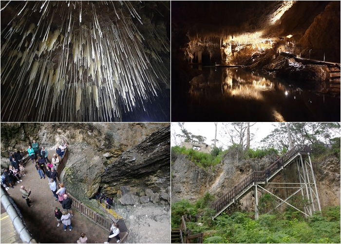
 Mammoth Cave was a one-way route, so upon exiting the cave we had to walk back to the start above ground along a path through the forest, enabling us to enjoy wildflowers and wildlife.