When we first ventured out on our full-time travels, we planned to get involved with a disaster relief organisation, such as BlazeAid, when we could. Well, that was three years ago and finally the opportunity arose on our way through central NSW towards Maroochydore. We found that we had nine days to spare and the northeast of the state was being ravaged by fires so a quick internet search found several BlazeAid camps virtually along our route. Once there we discovered that the primary activity for volunteers in the fire zones is the repair of boundary fencing. More on that a little later.
At the time of our last post we were in South Australia’s Barossa Valley, soon to follow the Darling River Run, a 952 km outback drive that follows the Darling and the Barwon Rivers from Wentworth on the NSW/Vic border to Walgett in northern NSW, passing through the towns of Pooncarie, Menindee, Wilcannia, Tilpa, Louth, Bourke and Brewarrina. From the Barossa we headed due east through Renmark then into Victoria briefly (just 110 km) before crossing the Murray River into NSW at the little town of Curlwaa (such an odd name). We joined the Darling a little west at Wentworth. It’s not possible to see the river from most of the Run, but you can see its path off to the side, marked by the trail of huge River Redgums that line its banks. We cross or reach the river at each of the towns along its length. At Pooncarrie the sight was very sad, with just a few puddles marking the existence of a once mighty river. However, in places, expanses of water did exist in areas where the waters are held back behind weirs.
Clockwise from top left: Looking back to Victoria across the Murray at Curlwaa; Relaxing next to the Darling at our camp in Kinchega NP near Menindee (4 pics); The ritual of dropping tyre pressure all round upon reaching the rough gravel roads.The shingleback, or stumpy-tailed lizard was a common sight on the Run, slowly crossing the road; downstream of the Tilpa Weir before and after water was released from an upstream control device; sunset from our campsite at Tilpa Weir; roadside Christmas decorations outback style.As we approached the city of Bourke the landscape took on an unusual colour……green, the result of rains a week or so earlier, images of which made news headlines around the world; the brown, low level water of the Darling at BrewarrinaOur camp overlooking the Darling River at May’s Bend near Bourke. Despite the colour of the water, the river supported a large population of pelicans, plus darts, swallows, parrots, cormorants and apostle birds making up some of the local bird population.There’s not much to write about the town of Brewarrina, other than the John Murray murals that adorn several public buildings
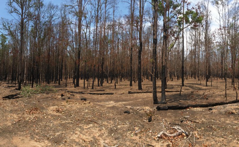
As we’d been travelling along the Run, we continually assessed our progress in order to reach Maroochydore in time for Blake’s scheduled warranty repairs. With two weeks to travel the remaining 922km we decided we had ample time to put in a few days with BlazeAid in northeast NSW. Several BlazeAid “campsites” had been established in the Tenterfield/Casino area which weren’t too far out of our way. We settled on a campsite at Ewingar, a little community on the Clarence River 25km south of Tabulam. As we meandered along the Clarence River valley from the Bruxner Highway towards Ewingar, the fire smoke became increasingly thicker. We wondered what we were heading into, and continually checked the RFS website to make sure we weren’t driving into a fire front. As we got closer, it was evident that the damage had already been done, with vast swathes of forest and grazing land blackened by the recent fires, with fences and farm buildings destroyed.
The little Tenterfield Lodge caravan park at Tenterfield. The Park had been threatened by fires a few weeks before we arrived, with all tourists ordered to hitch up to their vans and await the evacuation order. The winds changed and the park was spared.This is what greeted us upon our arrival at Ewingar. The air was thick with smoke, and the sun nowhere to be seen.
We were able to spend nine days with the BlazeAid team. Numbers of volunteers waxed and waned during our time there, but for the most part we retained the same team members in our small group of four to five, sharing the load with and learning from experienced BlazeAid volunteers Fred and Brendon. We had an absolutely fabulous time working together with a single goal; finish the 1.2 km road boundary fence before we had to leave. Some of us worked a few long days near the end to see that we achieved that goal, which we did. The work was hard, hot and tiring, but Carol and I learnt a variety of new skills including chainsaw use and chain sharpening; use of mechanical hand-held picket drivers; wire straining and fence twitching. By the end of our five days we were buggered but immensely satisfied. By the time we left about 50 property owners had registered requests with our little camp requiring over 120km of fencing to be restored. About 7 km had been completed by the time we left, so they’ve a long way to go.
The Ewingar Community Hall, our camp’s headquarters; that’s one hell of an onion; inside a farm stay property a few km from the Community Hall to where we relocated for a few days whilst the 3-day Ewingar Music Festival was held at the Hall.Our team, and the results of our labours, 1.2km of burnt out fence removed and cleared and a 5-strand fence erected in its place.It wasn’t all hard work. On our Sunday “RDO” Carol and I took to the Clarence River for a paddle, and enjoyed the broad line-up of artists at the music festival on the preceding Saturday night. We had previously seen the Church family band “The Haystack Mountain Hermits” in the middle pic, featured on the ABC’s “The Recording Studio”.
After leaving Ewingar we detoured to Lismore for two nights to see Nicole, James and Connor, then off to Maroochydore where Bushtracker had Blake for four days to repair a long list of warranty items, the main ones being the air conditioner and replacing five internal walls, as two had cracked several weeks earlier. The factory did a good job and Blake is ready again for more adventures, but not just yet.
We are now back in Lismore for a few days before returning to Sydney for three months to spend Christmas and time with family and friends and enjoy Steve (Carol’s son) and Mel’s wedding on the 29th February.
Fun in Lismore pool with Connor and Nicole; a rather colourful breakfast of blue pancakes at “The Bank” café in Lismore. The pancakes were so blue I thought that I was eating a blue dish sponge.
It is now only three weeks to the end of our third year on the road, although we actually reached the three-year milestone last month, having set out in early November 2016. Over that time Henry has travelled 92,900 km, Jake travelled 11,700 km and Blake has travelled 39,800 km. We’ve travelled extensively through all states and territories except WA, which we plan to reach next year. I won’t be publishing another post until we return to the road in March 2020, or we give an update as to our plans.
‘Till then, Carol and I wish all our readers a Happy Christmas, a wonderful New Year and happy and safe holiday period. We hope to be able to see many of you over the coming months whist we’re in Sydney. Thanks for following us.
Our route along the Darling River Run to Maroochydore via EwingarOur past three years plus our 2015 long service leave travels. 2015 LSL – purple; 2017 – black; 2018 – red; 2019 – orange. Only WA to go!!
We were heading south out of the Northern Territory to find cooler weather…… Well, we found it!! The maximum temperature in Alice Springs on the day we left was 41 degrees and we hit the southerly before we reached to NT/SA border. Reaching Coober Pedy maximums were down to 27, then on to the Clare and Barossa Valleys where maximums of 16 to 19, minimums down to 4 and wind gusts up to 57 kph prevailed. We certainly got more than we bargained for.
Leaving Alice Springs we bypassed Uluru, Kings Canyon and the Olgas as Carol had bruised her heel during an earlier walk, making hard-surface walking quite painful. No point visiting those locations if you can’t walk, and with the temperatures forecast in the low 40s we decided to continue south. Raised dust from the approaching southerly reduced visibility on several sections of the Stuart Highway near the border. We saw several large willy willies (dust ghosts) whipped up possibly reaching heights of 100m or so. Occasionally we had to slow down or accelerate to avoid them as they crossed the highway.
Raised dust near the NT/SA border from an approaching cool southerly change.
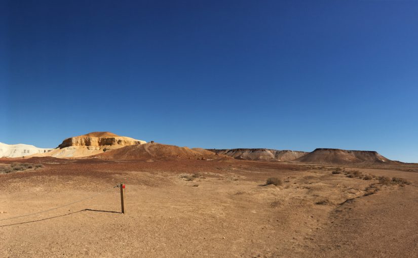
Next stop, Coober Pedy. A fascinating treeless desert made famous by its opals. Discovered in 1915, opals are still mined by some of the 2,500 occupants of the town, 50% of whom live underground. Coober Pedy and two other nearby fields produce 85% of the world’s opal supply. The town looks quite devoid of houses, but they’re there, just underground, the only indicator of their existence being ventilation pipes sticking out of the ground. Several of the underground buildings are open to the public. We took a 5-hour bus tour around town and out into the mine field, normally prohibited by visitors, but our tour operator owned a mining lease allowing him to drive through the landscape of mullock heaps.
There is estimated to be over 1.5 million open abandoned unfenced shafts across the Coober Pedy Opal Fields. That’s good reason to keep tourists away.The Oasis Caravan Park was an oasis to us. With no air conditioner, scoring a site under the cover of shade cloth was a godsend; I tried to enter one of the local pubs for a drink, but the door was locked; Ever seen a road train full of camels before? This one was at the Marla Roadhouse between Coober and the borderTop left is a re-creation of an early miner’s dugout whilst the other pics are of a current house, and yes, that is a swimming pool, though it is constructed in an above ground addition to the underground house.Underground Serbian Orthodox ChurchOur bus tour took us beyond Cooper Pedy to the Kanku-Breakaways Conservation Park along the edge of which runs the Dog fence, a 5,300 km unbroken barrier through SA, Qld and NSW to prevent dingoes entering the sheep country to its south. Such stunning vistas exist in this desolate place.The vast endless plains are interrupted by the striking Breakaways, formed by sedimentary deposition under the inland sea followed by 70 million years of erosion.
We continued heading south as the days were still hot, forcing us to keep driving until the early evening so we could remain in Henry’s air conditioning until the cool of the evening. Past Woomera, through Port Augusta at the top of Spencer Gulf then into the southern Flinders Ranges. Quite a change from the red dirt we’ve travelled through over the past two months.
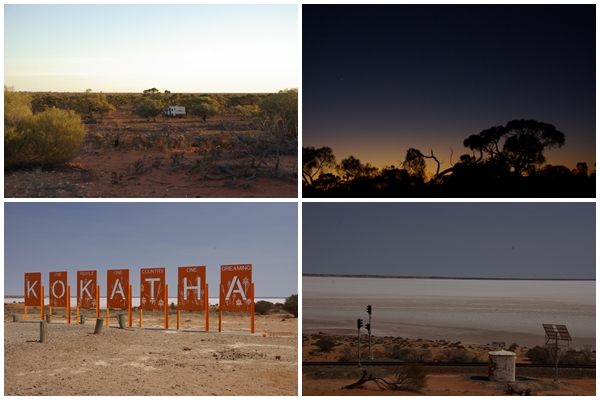
We take advantage of roadside campsites as often as possible. This one (top pics) near Glendambo in SA’s salt lake region was a cracker. Well off the road and we the only ones there, we could enjoy the beautiful sunset once the flies went to bed; Lake Hart, one of the smaller salt lakes in the region.The southern Flinders Ranges are dotted with quaint little towns, such as Murray Town (top left) and abandoned, broken down old stone farm buildings amongst the grain fields; Wirrabara received a grant for this silo art project, painted in October 2018 depicting a forestry theme and the rare red-capped robin.
We soon arrive in South Australia’s wine country. Our plan was to base ourselves in the Barossa Valley and do day trips around the area including the Clare Valley, 100km to its north. Passing first through Clare on our way to the Barossa, the Clare Visitor Information Centre and another visitor in the Centre convinced us to stay in or around Clare for a few days before continuing south. So we headed out to the nearby historic village of Burra, which was an absolute gem, we thought we’d make it our base for the Clare Valley. Whilst we enjoy wine, we’re not too keen on going from cellar door to cellar door for tastings, as we always feel obliged to buy, and can spend a small fortune. So we spent almost two days taking a self-guided heritage tour through the mining town of Burra, before shifting camp to Blyth just out of Clare and then enjoying several country drives through the Clare Valley, and stumbling across the beautiful little town of Mintaro with a great pub and Reillys cellar door. The Clare Valley boasts several bike trails, but the winds were strong so we decided to leave the bikes bolted to Henry’s roof. Whilst in Burra we bumped into a couple, Di and Lance, who we’d met in Coober Pedy, four days and 800 km earlier. They invited us over to their quaint bluestone B&B in Burra for a meal and a few wines. Another great evening spent with those two.
Burra, 43 km northeast of Clare, exudes olde world charmSome of Burra’s historic past including the Redruth Gaol (1856-1922) and the nearby village of Hampton (1857-1960)More of Burra’s historic past which includes the Unicorn Brewery Cellars (1873-1902); miner’s dugouts along Burra Creek, when in 1851 there were 600 dugouts housing 4,400 people; early cottages and houses.The Burra Mine Historic Site contains extensive remains of the copper mining operations of 1845 (shaft) to the 1980s (open cut), providing a fascinating insight into the scale of the undertaking.There’s still a local living at the mine site (bottom left)Mintaro is a classic historic town when, at the end of its heyday, fuel was 87 cents per litre.A pub lunch at Mintaro’s Magpie and Stump Hotel
There are several towns in the Barossa Valley, many well-known such as Tanunda, Angaston and Nuriootpa. We stayed in the tiny, lesser known town of Greenock, with its lovely camping area at the sports oval. We visited three large wineries of the valley, but bought very little, preferring to take driving tours through the region along roads less travelled. There was one place I had to visit in Greenock, which, once again, Carol took no interest in attending. Lincoln Nitschke’s Aviation Collection is not to be missed.
Next destination……Bushtracker factory at Maroochydore Queensland via the Darling River Run, before returning to Sydney mid-December.
Grain fields as far as the eye can see on the outskirts of the Clare and Barossa wine growing valleys. Greenock Hotel.Mengler Hill Sculpture Park overlooking the township of TanundaBarossa Valley streetscapesThe amazing Chateau Tanunda winery. Built in the late 1880s, it is home to some of the earliest plantings of vines in the Barossa Valley, dating back to the 1840s, Australia’s largest (37,674 square feet) and oldest wine Château and a designated monument in Australia’s Register of State Heritage Places.Seppeltsfield is another iconic and beautiful Barossa winery. It was established in 1850 by Joseph Seppelt for tobacco production, but grew into wine and vineyards with later generations. Ownership remained in the Seppelt family until 1985. I love the entrance to the ladies toilet.Jacobs Creek Winery is located in Rowland Flat in the southern Barossa, as are Pernod Ricard Winemakers, outside of which stand these magnificent trees. (John B, we thought of you when we saw these)Lincoln Nitschke began making model planes at the age of 8. When old enough he acquired his glider licence and has been involved in aviation all his life. He has amassed an amazing private collection of complete and partial war planes, primarily WWII, plus engines, cockpits, photos and other bits and pieces, all housed in one massive shed. He still continues to make model aircraft.The orange line from Alice to the Barossa is the route of this post. By the publish date we’d reached Collarenebri in far north NSW and the heat is catching us. More on that next post.
Wow, what a fantastic drive it is from Darwin to Alice Springs. We had planned to spend a few days in the Litchfield National Park after leaving Darwin, but escaping the heat was our top priority and hotter days were predicted. Water flows were rumoured to be down in Litchfield also, and knowing a cooler change was on its way up the Centre, we wanted to meet it head on. So on we pushed.
Our first overnight stop was the old railway town of Pine Creek where we stayed in a van park at the rear of the Lazy Lizard Tavern with a very welcome swimming pool. Back on the road we continued through Katherine. No stopping there as we had passed through it heading north just a few weeks earlier. We had thought that we might spend the night at Mataranka to enjoy the springs again, but we arrived quite early in the day, which would have meant camping in the hot afternoon so we continued south. Our journey took us through the iconic Daly Waters township and pub. We stopped for a drink (wine for Carol, Coke for me) before checking out the few historic cars and bikes opposite the pub, then off to a free roadside campsite in an old quarry, pulling in fairly late after a 500km day.
The iconic Daly Waters Pub. The coolest room was the dining room where Carol made friends with a buffalo. The beer garden looked “cool” but was very hot.Part of the old vehicle collection at the Daly Waters PubThose who read my recent post titled “Crossing Over” might remember me likening one of the rock structures at the Western Lost City to the Indian Motorcycle logo. Well, an Indian motorcycle was at Daly River, and here is the comparison. Maybe a little imagination is required.
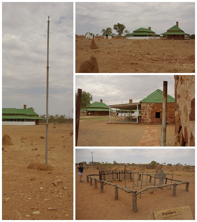
Continuing south from our night in the quarry, we stopped at the Tennant Creek Telegraph Station. The Overland Telegraph Line (OLT) connected Australia to the worldwide telegraph network and stretched 3,000 km from Adelaide to Darwin. The telegraph station was one of eleven repeater stations between Port Augusta and Darwin. Under the supervision of Charles Todd, Postmaster General of South Australia, this massive engineering project was commenced in 1870 and completed in just 2 years. We also visited Barrow Creek and Alice Springs Telegraph Stations on our way south. In 1872 it took 7 hours for a message to reach England from Adelaide, the Morse code message being relayed along the OTL repeated from station to station. Prior to 1872 messages took 3 to 4 months to travel by boat.
Tennant Creek Telegraph StationBarrow Creek Telegraph Station between Tennant Ck and Alice Springs. The stations were spaced at approximately 250km. Any further would render the signal inaudible. A more modern form of communication in the outback concentrates mobile phone signals to a stand on which you rest your mobile phone. They seemed to only work for the Telstra network, and were located along the Stuart Hwy in NT.Alice Springs Telegraph Station, the birthplace of the Alice Springs township. It is now a major tourist attraction with café and guided tours.
Before reaching Barrow Creek and Alice Springs we spent a night at Devil’s Marbles, camping at the base of one of the many piles of rocks scattered across the Karlu Karlu Conservation Reserve. We got there about 4:30 in the arvo and the flies were there to greet us. Thank goodness for fly nets over the head. Not such a good fashion statement but they certainly reduce the number of flies ingested. The flies and I took a sunset stroll on one of the marked walks around the Marbles.
Next morning Carol and I did a 4km sunrise walk through another section of the reserve before many of the flies were awake before continuing south through Barrow Creek and on to the Alice. We stopped to spend the night 40km north of Alice at a roadside rest area on the Tropic of Capricorn. We arrived late afternoon and settled down. Over the following hour or so several cars cruised through and around the rest area full of locals. We felt ill-at-ease, contacted a van park in Alice and headed off to the Temple Bar Caravan Park, arriving just before dark and staying for a few days. Not your average van park, it was situated about 14 km out of town and contained a lot of cabins that housed semi-permanent itinerant workers. It was a lovely quiet, basic van park with nice grass for tourists and all the amenities we required. After receiving some good advice from the staff we did a day trip to Chamber’s Pillar then hitched-up the following morning and headed into the MacDonnell Ranges.
Alice Springs from Anzac Hill looking towards the MacDonnell Ranges; mural on the School of the Air entrance; our campsite at Temple Bar; the origin of the name Alice Springs was at the Alice Springs Telegraph Station behind which a “spring” was discovered in the river and named after the Sir Charles Todd’s wife, Alice. It turned out it wasn’t a spring. They then sank a well to capture the water.Chambers Pillar, 160 km south of Alice via some very interesting roads and scenery. Our return trip took us on different roads over about 260 km.Graffiti’s been around for a while. Until the coming of the railway in the 1920s, Chambers Pillar was a landmark in the desert on the long overland journey from Adelaide to Alice Springs. John Ross led the exploration party for the OLT in 1870-71 (left). Alfred Giles was with the OLT exploring party (top right). AP Cheeseman was a haulage contractor on the OLT construction and William Hearne was also with Ross and Giles (bottom right).It’s amazing what you’ll find in the outback. Here on a corner in the middle of nowhere on our way to the Pillar was an ATM and public phone plus other random stuff. I tried to make a call but the line must have been down!!
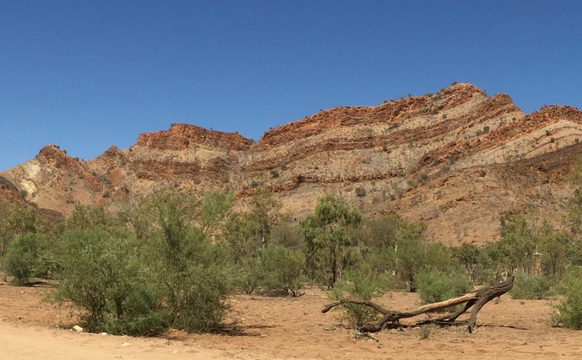
The MacDonnell Ranges stretch about 150 km east and 160 km west of Alice Springs. The West MacDonnells are the best known with locations in the West MacDonnell National Park such as Simpson’s Gap, Stanley Chasm, Ormiston Gorge and Palm Valley. The East Maccas are far less famous, not even having a national park named after them. We visited the east first, camping in the Trephina Gorge National Park. Such a magnificent place, not just the Trephina Gorge, but the 80 km drive through the Ranges along the Ross Hwy to get there. We had the camping area to ourselves for two nights. I did two short walks (2.5 km each) and marvelled at the scenery.
Trephina Gorge and the surrounding escarpment (East MacDonnell Ranges)
From Trephina Gorge we moved over to the West MacDonnell National Park, camping at Elery Creek Big Hole and Palm Valley. From Elery Creek we did a day trip to most of the popular locations along the northern arm of the national park before heading around to Palm Valley on the southern arm. Elery Creek had a large waterhole containing freezing cold water. It was deep and had little opportunity to warm up as it was sheltered by the gorge walls. A busy day-use location but very few campers. We met a lovely couple at Elery Creek and again at Palm Valley, Greg and Jo from WA, enjoying conversation and campfire each night.
Elery Creek Big Hole in the West MaccasSimpson’s Gap in the West MaccasOrmiston Gorge; Glen Helen Gorge; a little Australasian Grebe in Elery Creek Big Hole
The inland sea once covered much of central Australia which was then subjected to massive upheaval and folding some 300 million years ago creating a mountain range to rival the Himalayas. The subsequent years of weathering, erosion and further geological movements have left a much-reduced twisted mountain range with a roller coaster of ridges and valleys.
Twisted Maccas. Stunning and stark mountain scenery.Tnorala (Gosse Bluff), believed to be formed by the impact of a comet, about 600m across, 140 million years ago, creating a crater that was originally 20 km across; Mount Sondor; Ochre pits, displaying amazing evidence of land upheaval. The ochre was created in horizontal layers on the bottom of the inland sea. The strata is now vertical.Birds that visited us at our campsite at Palm Valley, all viewed from our van. Major Mitchell’s Cockatoo; Splendid Fairy-Wren; Cuckoo (possibly); Australian Ringneck; Pied Butcherbird.A lion watches over the Finke Gorge National ParkThe Central Australian Red Cabbage Palm in Palm Valley in the Finke Gorge National Park
There are three significant dates that shaped Darwin: 19 February 1942, 25 December 1974 and 6 October 2019. The first is the date of the first of 64 air raids on Darwin by the Imperial Japanese Navy in WW2 occurring up until 12 November 1943, killing more than 230 service personnel and civilians and destroying ships, aircraft and infrastructure. The second date is when Cyclone Tracy made landfall at Darwin (3:30am) killing 71 people, causing A$837 million in damage (1974 dollars), or approximately A$6.85 billion (2018 dollars) and destroying more than 70 percent of Darwin’s buildings, including 80 percent of houses. The third date is when Blake’s air conditioning stopped working. Maybe the third incident didn’t shape Darwin, but it shaped how long we were to stay up north.
A lot of Darwin’s tourist attractions and tours centre firstly around the bombing of Darwin. Cyclone Tracy is given considerable coverage at the Darwin Museum, but we failed to visit that museum. We took a city tour in a WW2 Studebaker truck run by The Darwin History and Wartime Experience. A very interesting tour, but because the truck was open and a bit noisy, we struggled to hear all of the commentary provided by the driver.
During our time in Darwin, Carol returned to Sydney for five days for a family function. I had thought I might get out of town in her absence, but it turned out that our friends Steve and Bron had booked into the same van park for a similar length of time, so I stuck around to enjoy their company and to get some chores done on Henry and Blake. Carol and I made attempts to get the air conditioning repaired, but because Bushtracker do not fit the air conditioning units in accordance with the manufacturer’s recommendations (Bushtracker know best !!??) we were at risk of other repairers damaging the roof. Our safest option was to return to the factory in Maroochydore Qld and have Bushtracker do the work. That’s a 3,500 km cross country trip one way so we decided to suffer the heat and not have the repairs done until early December when we plan to be in Lismore, which makes the factory just 300 km (each way) out of our way.
It was bloody hot in Darwin, and even hotter at the van park in Palmerston with temperatures topping the mid to high thirties. The air was so consistently hot that it heated the water in Blake’s tanks to about 35 degrees, so I didn’t need to heat the water for a shower during our time there. With the water out of the tap too hot to drink we had a system of freezing bottles with small quantities of water to create copious quantities of cold water.
We were really fortunate to be in Darwin at the time of the Bridgestone World Solar Challenge, a 3,000 km dash from Darwin to Adelaide by cars powered by no more than five square metres of solar panels developed and engineered by university and college teams from around the world. Before Steve and Bron’s arrival, Carol and I visited the static scrutineering venue at the Convention Centre, getting our first close-up glimpse of some of the cars and their enthusiastic teams. Following Carol’s departure to Sydney, Steve and I went out to Darwin’s motorsport complex for the dynamic scrutineering and time trials. There we could get up close and personal to the cars and the teams. We attempted to get to every Aussie team, check out their cars and wish them well. We also spoke to members of several of the visiting teams (if they spoke English!). Some teams have a sufficient budget to create some beautiful looking cars, others are held together with gaffer tape and pop-rivets. The following day Steve, Bron and I watched the start of the race at Parliament House. We felt the heartache as some of the cars failed to start, but shared the team’s jubilation when they were able to sort out the problem, often simple, and hit the road, albeit a little late.
Upon Carol’s return from Sydney, we took no time to pack up and head south for a cooler climate.
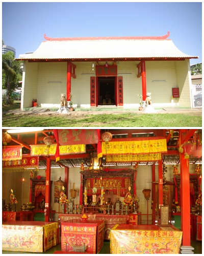
The only way to plan your stay in Darwin is at the Stokes Hill Wharf overlooking Darwin Harbour, then to finish your time in Darwin with good friends at the Darwin Trailer Boat Club watching the sun set over Fannie Bay.Some of the street art around the cityThe underground oil storage tunnels, constructed after the newly completed and filled above-ground oil tanks were destroyed during the first air raid by the Japanese. The tunnels, a dismal failure, with leaks and numerous other issues, were not completed before the end of the conflict and were never used as planned. Compare that to the slick engineering on display at the Solar Challenge static scrutineering.Darwin’s Parliament House. Completed in August 1994, the building was designed to harmonise with the Top End’s tropical climate and Australian materials feature throughout. The tops of the four corner columns are fashioned to represent the bombs dropped on Darwin in 1942.The Chinese Temple, erected after the original Temple, built in 1887, was destroyed by Cyclone Tracy in 1974.Our time in Darwin almost came to an unfortunate end as a local hesitated, then ran directly across in front of us to catch a bus. We missed him by millimetres (he’s at the left corner of Henry in the photo). Fortunately, the car behind was far enough behind so as not to run up our rear.Adelaide River War Cemetery. Located 116km south of Darwin, the cemetery holds 434 military burials in total and the adjoining Civil Cemetery honours 63 civilians including the nine post office workers who were killed in the 19 February 1942 bombing of Darwin (bottom).Dynamic Scrutineering Day. Clockwise from top left: The Lotz Solar team’s “Eagle Two” (Poland) had a stylish rear end. Unfortunately the front suspension collapsed after the time trial and they had to withdraw; Steve checking out the Australian Technology Network of Universities’ (ATN) entry “Priscilla”; China’s “Sun Shuttle III’, the ugliest entry; Tafe SA’s “SAV”, a ute format towing a fifth-wheel hitch trailer. The top of the trailer is all solar panel. This vehicle is entered in “Adventure Class” as it doesn’t comply with guidelines for the two competitive classes; What I dub “The Flying Bugatti”.Some of the “Challenger Class” entries. Aerodynamic, single-seat speed machines.A different take on the design of Challenger Class entries. If they cop a cross wind from the wrong side, they’re prone to flip, as several did during the event.A range of “Cruiser Class” entries. A minimum of two occupants, with more points gained for practicality and if additional passengers are carried.Cruiser Class entry from the UNSW Engineering Sunswift team “Violet” (top two pics); ATN’s “Priscilla” (bottom).
This is another article that I have written for the Campervan and Motorhome Club of Australia’s “Wanderer” magazine.
Articles are to be 1,200 words minimum and limited to 8 photos, though I’ve submitted 11. Because there was so much to see in the Kakadu National Park I’ve added some more pics in the post at the end of the article. I hope you enjoy the read.
Words by Graham Watson (N97206); Photos by Graham Watson and Carol Willcox
Some call it Kakadu, some call it Kakadon’t. We explore this iconic Top End park and make up our own mind.
As we’ve been wending our way around Australia over the past three years, we’ve often exchanged plans and ideas with other travellers. When we’ve mentioned that we planned to visit Kakadu, the response from several travellers over that time has been surprising. At the mention of “Kakadu” they prefer to call it “Kakadon’t”……. DON’T BOTHER going there. Reasons such as “It’s not as good as it used to be”, “There’s too many tourists these days”, “The National Parks people have spoilt it by restricting where we can drive and camp” have been cited.
Undaunted by their negativity, we ventured into the Kakadu National Park in the Top End of the Northern Territory in the first week of October for five days. We arrived at the end of the Dry Season, or Kunumeleng (pre-monsoon storm season; one of the six indigenous seasons) with temperatures in the very high 30s every day dictating how, what and when in the day we were to explore. The Park was dry, very dry. So much so, several of the walking tracks were closed, wetlands were significantly reduced in size, waterfalls weren’t falling and some areas, such as the iconic Ubirr lookout, had succumb to intense bushfires forcing the closure of campgrounds and more tracks. National Parks made great efforts to reopen various areas as soon as possible once safe.
Our original plan had been to camp in several of the managed and unmanaged campgrounds dotted throughout the Park, but the heat urged us to take advantage of power available at caravan parks in several resorts within the Park for our air conditioner. Australia is struggling through an unprecedented “dry” at present, and our decision to visit the region so late in the season both contributed to not being able to see the Park at its “best”, but it didn’t detract from what the Park had to offer. My expectations of Kakadu were formed from what I remember seeing in the tourist brochures and TV documentaries, showing extensive areas of wildlife-filled wetlands stretching across vast floodplains. However, that is a jaundiced image, as Kakadu has so much more to offer.
There are two access points to the Park, from the north near Darwin via the Arnhem Hwy, or from the south near Pine Creek via the Kakadu Hwy. Both routes are about 200km, sealed and meet at the township of Jabiru near the northeast corner of the Park. We entered the Park from the south, having travelled from Queensland via the Savannah Way. From the south, the Park boundary is near the Mary River Roadhouse, about 50km from Pine Creek. If you are entering the Park from the south, be sure to purchase your Kakadu Park Pass from the Katherine Visitor Information Centre as they are not available at the Roadhouse. They can also be purchased on-line, which we had to resort to. Also, grab a copy of the Kakadu Visitors Guide. It has a wealth of information about the Park and what to see and do.
Roadhouse staff directed us to Lower Ikoymarrwa Falls, a local swimming hole not shown on the tourist maps, a few km inside the Park. Despite the season, water was still coming over the falls, albeit minimal. The water was cool, and no freshwater crocodiles made their presence known.
Several iconic locations can be accessed from the Kakadu Hwy as you head northeast towards Jabiru, but the dry had rendered several of them closed, such as Gunlom, renowned for its infinity plunge pool and waterfall; and Jim Jim Falls. Both of these are on unsealed roads with Jim Jim requiring high clearance 4WD. Disappointing as it was with these closures, we were not disappointed by Maguk, just 10km of reasonable unsealed road off the highway. We had the van in tow and were able to negotiate amongst the trees and parked cars to find a parking spot in the carpark. It was then a 1km rough walk to a beautiful clear plunge pool with a waterfall entering it at the far end. Again, no crocodiles made their presence known whilst we were there. A reasonable crowd were there but the large pool more than accommodated everyone.
In order to take advantage of 240V power for our air conditioning, we booked into Cooinda Lodge, one of several resorts in Kakadu. We drove into several of the bush campgrounds on our way, and had the weather been cooler, we would have enjoyed the remote ambience. However, the facilities at Cooinda, especially the large resort pool, bar/bistro and outdoor dining areas made up for a lack of remote ambience. Happy-hour drinks were also popular with us.
Adjacent to Cooinda is the Yellow Water Wetlands at which you can look out across the South Alligator River from the walkway, or take a Yellow Water Cruise. Several 1.5 or 2 hour cruises are available throughout the day. We booked a sunset cruise on a 36-seat covered “tinnie”, piloted by our indigenous guide, Ruben. Ruben was a cracker of a guide. He didn’t stop talking to us for the entire 2 hours, and allowed any kids who wished, to pilot the boat for a short time. His information was detailed, covering pre-settlement history, indigenous and white settler history, animals, birds, culture and family. We saw numerous bird species, crocodiles, wallabies, buffalo and horses. Absolutely fascinating, and we were treated to a stunning sunset. Each evening, flocks of magpie geese make their way across the setting sun to their roosting location after having spent the day feeding at one of the wetlands, such as Mamukala.
A stand-out feature of Kakadu is the aboriginal rock art that is accessible to visitors at various locations throughout the park. There are more than 5,000 art sites in Kakadu, with only a fraction accessible to the tourists. But that’s fine, there’s plenty of variety to see in that small sample. We’ve seen a lot of rock art in our time in the outback, but the style used in Kakadu is very different and very detailed. They include naturalistic paintings of animals, traditional x-ray art and paintings of the first European contact. There are wonderful examples at Burrungkuy (Nourlangie) and Nanguluwurr off the Kakadu Hwy, and at Ubirr, 40km northeast of Jabiru.
The Bowali Visitor Centre near Jabiru contains a wealth of information about Kakadu and includes a theatre, library and interpretive display, plus a café and gift shop. Up-to-date information on road and track closures and access is also available and should be sought out. They also provide Ranger tour times and the best daily times to visit Cahill’s Crossing, a low-level weir on the East Alligator River where crocodiles gather either side of high tide, at which time the incoming tide pushes upstream over the weir, then back out again, bringing with it a ready supply of fish for the eating. With the Visitor Centre being located at Jabiru, you’ve had to drive 200km through the Park before reaching it. So, if you rely on the Centre to assist with your Kakadu planning, you’re likely to have to double back over that section of highway to enjoy what you’ve missed. Be sure to seek as much information as possible at either Darwin or Katherine Visitor Information Centres, or on-line, before you enter the Park so as not to miss anything before reaching the Bowali Visitor Centre.
We visited two wetlands, Anbangbang Billabong and Mamukala Wetland that, despite the prolonged dry season, still held water, providing feeding grounds for vast numbers of birds including Jabiru (black-necked stork), egrets, herons, magpie geese, plumed whistling-ducks, shelducks and a variety of other ducks, royal spoonbills, ibis, white-headed stilts, swamphens, lapwings, willie wagtails and many others that I couldn’t identify. Anbangbang has a circuit walk around the billabong and Mamukala has a large bird hide, both of which provide for excellent bird watching.
Kakadu isn’t just wildlife and aboriginal art; it also boasts some spectacular cliffs and escarpments accessible by car or foot. Several walks were closed due to the extreme heat and fire presence, but we were able to enjoy several small walks and lucky to gain access to Ubirr in the northeast corner of the Park. Closed for several days and earlier in the day we were there due to a bush fire, it reopened just as we approached so were able to climb to the top of the escarpment to enjoy the iconic views across the Nadab floodplain and the neighbouring ranges.
What’s our opinion of Kakadu; is it a DU or a DON’T? Ignore the naysayers and those who preferred the Kakadu of 40 years ago. DO Kakadu. What is available to see is dependent on the time of year you get there. Late in the season it was dry and hot, but with the advantage of there being a small number of tourists around. There was plenty of space in the campgrounds and resorts. There’s always a trade-off. Will we be back? You bet. We plan to return in April next year at the end of the Wet (if there is one), to see Kakadu in an entirely different light. We plan to bushcamp, provided the Wet isn’t too late, which might make access roads to the camps impassable.
A large croc sunning itself in the late afternoon on the bank of the South Alligator River.A Black-necked Stork (Jabiru) lunging at a snake or small eel that it successful caught for an early dinner in the South Alligator RiverSunset over KakaduFlocks of magpie geese returning to roost at sunsetMaguk plunge pool. Worth the 1km walk from the carpark.Cooling off in the Lower Ikoymarrwa Falls rock hole. It’s amazing that there are springs that continue to flow, even in such a dry season.The depleted and scorched Nadab floodplain from the Ubirr lookout.Namarrkon the Lightning man (top left) and his wife Barginj (lower) with a Leichhardt’s grasshopper (top right). At the bottom are family groups of men and women on their way to a ceremony.X-ray painting, probably of a barramundi.
Alkayhko the fire woman (left of the three) is one of the First People who created the world. She has four arms and banksia flowers attached to her head.
More crocodiles. Have you ever seen the inside of a crocodile’s mouth before; “The Boss”, the largest male croc in the tour section of the South Alligator River; A croc crossing the causeway at high tide at Cahill’s Crossing; two crocs lurking upstream of the causeway waiting for fish.Clockwise from top left: Magpie Geese at Mamukala wetland; White-headed Stilt at Mamukala; Comb-crested Jacana (aka Lotusbird) in the South Alligator River; a large group of Royal Spoonbills, with some egrets, working there way along the Anbangbang Billabong, bills submerged, in search of food on-mass; a Pied Heron at Mamukala.
Clockwise from top left: pretty Plumed Whistling-Ducks in South Alligator River; A pair of majestic White-bellied Sea Eagles at South Alligator River; Magpie Geese over Mamukala.Some more Aboriginal art from the region.Kakadu has some magnificent landscapes.Fires in and around Ubirr
Just north of where our journey along the Savannah Way joined the Stuart Hwy, is the small township of Mataranka. With a population of just 250 it has two great spring fed thermal pools, one at Bitter Springs and the other on the other side of town at the Mataranka Thermal pool. Mataranka was also made famous as the setting of Jeannie Gunn’s 1905 novel “We of the Never Never”. We decided the stay at Bitter Springs Caravan Park thinking it would be close to those springs. Unfortunately it was a hot 800m walk to the springs, but at least the van park was shady, providing relief from the 40 degree heat, and mains power for our AC.
We spent two nights in Mataranka to enjoy both thermal pools and visit the site and cemetery of the Elsey Homestead, the setting of ‘We of the Never Never’.
From Mataranka it was a short drive to the major centre of Katherine and the Nitmiluk National Park (Katherine Gorge). Having kayaked 3 gorges fourteen years ago with Trevor and Dave I was looking forward to doing it this time with Carol. Unfortunately the traditional owners have banned kayaking in the lower gorge, requiring a boat trip to the second gorge to hire a double kayak for $70 per person. We were also advised that the water level in the gorges was down significantly so we gave it a miss, took a short walk to a lookout and used our time keeping cool in our air conditioning, with temperatures still reaching 40 degrees in the shade. Katherine also boasts thermal pools which we thought we’d check out, but due to improvement works being carried out, the trek to the pools was quite long, so we decided not to return with our swimmers.
Next stop….Kakadu National Park after an overnight stop at the Mary River Roadhouse on the Park boundary.
Amazingly clear waters of the Mataranka Thermal Pool (top) and Bitter Springs.Jeannie Gunn’s memorial and her husband’s grave at the Elsey Cemetery; Welcome shade at the Bitter Springs van park; frozen Kangaroo tails for sale at the Mataranka supermarket.Katherine Gorge; A Bower bird’s bower near the Nitmiluk National Park visitor centre; camping at a cattle station just out of Katherine.“How can we get that satellite dish onto Blake’s roof? It would provide awesome TV reception” (Mary River Roadhouse campsite. The dish was being used as a fish pond, making it a ‘fish-dish’).
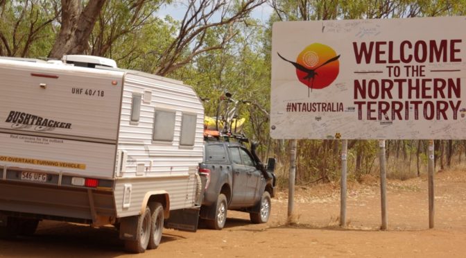
This is our fourth venture into the Sunshine State with a caravan in tow. Whilst coming close to the QLD/NT border on our previous journeys, we’d never crossed over, until now. Hello Northern Territory!!
Leaving the Atherton Tablelands we headed west following the “Savannah Way”, which is a drive that links Cairns and Broome via Katherine. Our first stop deviated from the popular Savannah Way route, taking us to Chillagoe which is renowned for its limestone caves. It also boasts ruins of a once bustling industrious ore smelter, amazing natural rock formations, aboriginal rock art and a one-man collection of Ford cars and trucks. We saw everything together with the exception of the Ford collection. For some reason known only to Carol, she wasn’t interested in that.
Continuing west we took the 600km unsealed Burke Development Road to Normanton. It’s the Savannah Way less travelled option, and as we’ve not passed that way before, it was beckoning us to use it. Nearly mid distance to Normanton is the only camp area available. On the banks of the Mitchell River, in the middle of nowhere, with space for just one or two camps, we spent a relaxing 2 shady days with no one else around with the exception of 3 passing trucks. We kept a lookout for freshwater crocodiles known to inhabit the river, but none made themselves visible, even with me swimming in the river.
After collecting groceries, fuel and water at Normanton, plus doing our washing, we left the Savannah Way and took another road less travelled to the Gregory River on our way to Boodjamulla (Lawn Hill) National Park. We were at Lawn Hill 4 years ago and loved it, so had to come again on our way past. Spectacular gorges to kayak through, with cool waters to swim in, and extensive walks in the area. The gorge is an oasis in an otherwise arid landscape. As we have moved into spring, daytime temperatures are in the mid to high 30s, so activities needed to be restricted to early mornings and late afternoons. We paddled a few times and did a few short walks before travelling north to Burketown near the southern shore of the Gulf and rejoin the Savannah Way.
Burketown is worth a look, but not a very long one. In fact we saw all the sights recommended by the van park managers in about 2 hours; the cemetery, thermal bore head, meat works ruins and the Albert River. We saw one salty croc sitting on the other side of the river.
From Burketown, the Savannah Way took us north west running parallel to, but generally 100km from, the Carpentaria coast. The next major town was Mataranka, some 1,100 km away. About half-way along this section of the “Way” (within the NT) is the choice of routes, directly west on sealed road to the Stuart Hwy, or the unsealed route less travelled heading north through Limmen National Park. Which way did we go? You guessed it! We stayed at two roadside free camps and two camps in the Limmen National Park along the way.
We unanimously award the “Savannah Way” from the NT/Qld border to 130km from Mataranka, a total length of about 700 km, as the worst road we have ever travelled. It’s even worse than the road to the Cape, not for it’s severity of roughness, but for the sheer continuous and constant corrugations. Read more in the photo captions. So, after repairs to a drawer, a cupboard door, having to rehang the bathroom door in Blake and re-secure Henry’s rear bumper bar, it’s a welcome relief to be on sealed road for the majority of the coming months, and we’re taking a welcome rest in a van park in Mataranka, on a powered site to enjoy our air conditioning as we’ve had temps in the high 30s for several weeks. Under the circumstances, Blake and Henry have stood up exceedingly well. We’re still very impressed with Blake, though he keeps getting dirty, and Henry will be fitted with a new shock absorber in Darwin.
The Savannahlander, parked up at Almaden, 150km west of Cairns. The Savannahlander runs tours from Cairns to Forsayth.For a little town, Chillagoe at the eastern edge of north Queensland’s outback, packs a punch for interesting places to visit, including caves, interesting rock formations, an abandoned smelter works and a Ford museum. We’ve toured numerous caves on our journey, but these caves did not disappoint.Chillagoe’s abandoned smelter works and nearby rock formations. Opened in 1901, the smelters supported a workforce of over 1,000 by 1908. The works operated. on and off, until 1943, never making a profit in any production year.Chillagoe’s Balancing Rock and sunset in the Chillagoe-Mungana Caves NP.Aboriginal Art in the Chillagoe NP. It was nice to be able to photograph this site. Many art sites request no photos.Tom Prior’s Ford Museum. All vehicles started first time with a turn of the key.Our beautiful secluded campsite on the Mitchell River. Despite the apparent presence of freshwater crocs, I enjoyed a few dips in the flowing waters.Camping right on the Gregory River at the town of Gregory. Cool clear spring water flowed continuously at this popular free campBoodjamulla (Lawn Hill) NP, one of our favourite destinations in outback Queensland. We were treated to perfect reflections on one early morning paddle.50 km south of Lawn Hill is the Riversleigh World Heritage Fossil Site. It is a world away from the lush tropical forest and gorges of Lawn Hill. Only a small area is open to the public. Visible, amongst other fossils, are fossilised vertebra and gizzard stones of a 2.5m high, 300kg flightless Dromorsis murrayi, and the crescent shaped shell of a 200 kg Chelid turtle.Ruins of a meat boiling works in Burketown.The Arthur River in Burketown. The van park was surrounded by lovely mature gum trees, the leaves of which had been stripped by hundreds of pesky CorellasBirds of the Gulf Country: Great Egret (Ardea alba) at Mitchell River; White-gaped honeyeater Stomiopera unicolor) at Lawn Hill; possibly a Variegated Fairy-wren (Malurus lamberti) at Lawn Hill; Crimson Finch (Neochmia phaeton) at Gregory River; Red-tailed Black-Cockatoo (female)(Calyptorhynchus banksii) at Lawn Hill.Birds of the Gulf Country: Great Bowerbird (Chlamydera nuchalis) at Lawn Hill; Yellow-breasted pretty bird (unknownoris nameii) at Lawn Hill; Australian Bustard (Ardeotis australis) near Burketown; Bar-shouldered Dove (Geopelia humeralis) at Lawn Hill; Brolgas (Grus rubicunda) at Burketown.The key features within the Limmen National Park are the spectacular “Lost Cities”. Sandstone formed on the bed of the inland sea 1500 million years ago was later uplifted and cracked, forming joints that rain would eventually erode, leaving large pillars, often at angles that reflect the bending uplift. It was an amazing place to see.Several Lost Cities exist in the region. We visited the South and West Cities, both stunning but quite different. This and the previous photo are of the South City, which we visited in the early morning, walking straight from our van into the city.The Western Lost City is at the end of a 30km 4WD track. An interesting drive that ended at the 2.5 km long City.At the Western City were the “Invisible Man” (if you’re old enough to remember the TV series), and the inspiration for the Indian Motorcycles logo.It pays to advertise. Along the Savannah Way there are rusty, stripped wrecks of vehicles, smashed and abandoned. The Hell’s Gate Roadhouse just east of the state border took advantage of these free billboards in numerous locations. There’s always the opportunity to see spectacular sunsets in remote regions. Corrugations, the spurn of outback travellers. Whilst they feel like solid objects, they are generally ridges of loose sand across the road that can be easily flattened with the foot. However, hit them at any speed (above 20 km/h) and they feel like concrete humps. Out here they force the abandonment of standard driving rules. “Keep Left”….. not if the right side of the road is smoother. We travelled for hundreds of k’s on the wrong side of the road. You develop the ability to see around corners, but really you look for oncoming dust. On one day we didn’t see one other car from the opposite direction. “Drive on the road formation”….. not if the table drains are smoother. For much of its length, we kept off the formation and drove in the table drain, on either side of the road. A bit slow and soft in places, but a smoother ride was generally the outcome. Much of the worst 700 km was driven at between 20 km/h and 60 km/h.Our four journeys into Queensland: purple 2015, black 2017, red 2018, orange 2019. We came close to the border on several occasions, but have now crossed it.A close-up of our travels of this post (orange), from just west of Cairns in the east to Mataranka in the NT.
It’s been 7 weeks (today being 20 September) and nearly 5,000 km since my last post when we were at Fruitbat Falls on the start of our return journey from the Cape. I set out to cover our travels since then in one post, but as we’ve seen so much, it became too large, so I split it, hence this post being backdated by 2 weeks.
Heading south from the Cape we stopped overnight at a few of the roadhouses along the Peninsula Development Road and took a deviation to the mining town of Weipa on the west coast of the peninsula facing the Gulf of Carpentaria, spending 2 nights there and taking in a town/mine tour. The entire town is owned and managed by Rio Tinto. Two days was ample. From there we crossed to the east coast, to the Iron Range National Park and Chili Beach near Lockhart River. Despite being buffeted by strong winds for 3 of the 4 days we were at Chili Beach we had a great stay, visiting the little hamlet of Portland Road, which had an awesome café with northern views over Weymouth Bay and the ocean; the aboriginal art gallery in the community of Lockhart River; and the nearby airport that saw action in WWII. The road into Chili Beach was not recommended for caravans due to the number of creek crossings (mostly dry) but Blake handled the 3 hour/100km drive with ease.
Returning to the horribly rough Peninsula Development Road we followed it south until Lakefield National Park in which we spent several days at 2 campsites. Wetlands, creeks and rivers abound, but so do saltwater crocodiles, so there was no swimming or kayaking. Despite the warning signs, we didn’t see one croc on the Cape.
Leaving Lakefield NP, we travelled east through the aboriginal town of Hope Vale and camped one night at Elim Beach. A rough campground but lovely views across the Coral Sea.
Just south is the picturesque town of Cooktown. Fortunately it’s not as commercialised as the towns further south such as Port Douglas. Cooktown still holds some tropical charm with several historical buildings, the James Cook Museum, a charming botanical garden and a free camp at the racecourse. What more could you want?
Next destination was Cape Tribulation. A direct coastal route is available from Cooktown via the Bloomfield Track which is one route where we heeded the warning that it’s not suitable for caravans. It’s quite a steep challenging road, so we took the long way inland to return to the coast at Mossman, staying at a caravan park about 20km north of Mossman. From there we did a day trip north north to Daintree and Cape Tribulation. The Daintree Discovery Centre was interesting but the rainforest walk was no better than some we’ve done in the NSW Northern Rivers area. Are we getting picky?
A quick visit to the touristy town of Port Douglas (‘cause it’s there), then south to Cairns, where I dropped Carol off at the airport for her to return to Sydney for 2 weeks to catch up with Steve and Mel, and help with setting up their unit in Hornsby for tenants. I took myself to the Atherton Tablelands where I was fortunate to spend the 2 weeks on the property of Bushtracker friends Michael and Sue. They were there for my first 2 days before they hitched up and headed off to the Bushtracker Muster in Bourke, whilst I stayed on, living in the van but enjoying their magnificent views of Lake Tinaroo on their very private 2 acres. I visited some local towns that Carol and I hadn’t seen on our last trip through the Tablelands 4 years ago, and anxiously awaited her return. Leaving Mick and Sue’s, we spent the next 3 nights at the Valley View Caravan Park near Kuranda, giving us a whole new perspective on caravan parks before putting the wet tropics of Far North Queensland behind us to return to the dry dusty outback..
Weipa faces west, providing some spectacular sunsets over the GulfWhilst in Weipa, we took an interesting half-day town/mine tour, where bauxite is the money spinner. If you don’t fish, there’s not much else to do in this mining town.The Peninsula has some intriguing and stunning birds, including the dopey looking Bush Stone-curlew (Burhinus grallarius) and the majestic Palm Cockatoo (Probosciger aterrimus).Our camp at Chili Beach on the east coast. We had to set up facing away from the coast due to the very strong onshore winds that frequent the area.Every year between September and March, Metallic Starlings (Aplonis metallica) gather in NE Queensland to breed. Each night at about 6:00, hundreds put on a spectacular aerial display for about half an hour or more over a small island (Old Man Rock) just off Chili BeachA walk along Chili Beach netted us 2 beautiful Nautilus shells. We also enjoyed watching a family of Red-capped Plovers (Charadrius ruficapillus) in search of food.Archer River where it crosses the Peninsula Development Road. Apparently croc free so I had a dip.Our first camp in the Lakefield National Park, at Hanns Crossing. We felt a bit close to the croc waters of the North Kennedy River to be comfortable. The crocs here are salties.One of Lakefield NP’s many wetlands, this one being White Lily Lagoon (for good reason) supporting a Great Egret (Ardea alba), Brolgas(Grus rubicunda) and Magpie Geese (Anseranas semipalmata), plus lots of white lillies and probably a handful of crocs.Our second camp in Lakefield NP was at Kalpowar Crossing on the Normanby River. Despite the sign at our site warning of crocs, we felt safe as we were about 8m above the river level.A Rusty Monitor (I think) and a pair of Radjah Sheducks (Tadorna radjah) in Lakefield NPOld Laura Homestead in Lakefield NP, partially restored and preserved by Queensland NP. The Laura Station lease (12,800ha) was bought in 1879 for just over £8. By 1894 he had over 8000 head of cattle—the success due largely to the contribution of the Aboriginal workers. The first homestead was built in 1908 and improved and added to from 1925. The Old Laura Homestead was abandoned in 1966 in favour of New Laura, 24km north. The homestead fell into disrepair.Elim Beach, north of Cooktown, with beautiful vistas to Cape Bedford and across the Coral SeaCooktown’s James Cook Museum displaying HM Endeavour’s anchor and cannon, plus a variety of other artefacts from the region.Cooktown, named after “you know who”.On our way south towards Daintree, we deviated to the Bloomfild Falls and stayed one night behind a very remote, but popular pub, the Lion’s Den.Daintree Rainforest. The python was behind glass at the Daintree Discovery Centre.Cape Tribulation and Daintree NPThe beautiful Thornton Beach and quaint little Daintree villagePort Douglas, a tourist mecca.Michael and Sue’s property at Lake Tinaroo, my campsite for 2 weeks whilst Carol was in Sydney. The middle photo is the “view from their balcony”Herberton Pioneer Village on the Atherton Tablelands. One of the best pioneer villages and collections of memorabilia I’ve explored. Starting at the age of 6, Harry Skennar collected relics from around the Atherton Tablelands until his death in 2009 at the age of 75. All of the buildings are original, transported from around north Queensland when no longer needed. It is a fascinating and well organised place.A plethora of derelict vehicles can be found throughout the village. Not left to rot away, they’ve all been treated with rust inhibitor to preserve them in their “as-found” condition.For our “tractor loving” friends, here are some of the restored and unrestored examples at the village. Yes, the restored ones are the wrong colour….. green instead of orange !!! All of the restored John Deeres are in working order, some of which they start up daily.No dragon boats up here, it’s croc-boats. Plus some examples of the orderly displays through the village buildings.Herberton townshipOur last tropical campsite in FNQ at Valley View Caravan Park, where the wildlife can drive.
We made it to the tip of the top. Our 1,500km journey along the Cape York Peninsula from near Cobbold Gorge in the south to the north saw us reach our most northerly campsite, Punsand Bay, on Wednesday 30 June. We set up Blake on an awesome beachfront site which was ours for 3 days, had a bite of lunch, then headed off for the final 30km dogleg drive to the tip (Pajinka). We arrived at the carpark at low tide so were able to walk the beach for most of the way to the iconic sign. Unfortunately we arrived at the same time as five families who were travelling together. We made it to the sign just before them and set up a self-timer pic. Then one of the girls of the families took a few more pics of us, and I returned the favour, having them crowd around the sign together, maybe 20 of them. We were in no hurry to leave the Tip, after having travelled some rough roads to get here, so we enjoyed the scenery, the sea and the islands and watching all the families and groups take their pics.
We walked back to the car via the headland which gave a different perspective of the top of Australia. It’s quite exciting, really, being at the most northerly point of the mainland. We’ve now been to the most northerly (mainland), easterly (mainland) and southerly (of the continent). Next year we plan to tick off the most westerly.
Not satisfied with just the top of the mainland, we took a boat tour into the Torres Strait to visit Thursday (Waiben) Island, Friday (Gealug) Island and Horn (Narupai) Island. Whilst I found the tour to be a little disappointing, the Torres Strait was fascinating. Beautiful coloured waterways dotted with 280 islands (18 inhabited), strong currents, the occasional turtle and crocodile, and beautiful islands and islanders.
Having left Cobbold Gorge on 20 July, our journey to the Cape took us through the Atherton Tablelands west of Cairns. Having spent about 2 weeks in the area 4 years ago we stayed just 2 days this time at Mareeba primarily for washing and shopping to prepare for the Cape. We did our biggest shop ever at Mareeba. They’ll be thanking us for years. We stayed in a freedom camp called Ringer’s Rest a few clicks out of Mareeba, which was great. Quite a few campers but well spread out. We met another Bushtracker couple who were also on their way to the Cape. Both mornings at the camp hot air balloons passed overhead to land nearby, though one landed amongst the caravans.
Leaving Mareeba we really felt like we were on the way to the Tip. We couldn’t book into the campsite at the tip when we wanted it, but had to wait an extra week or so, so we took our time heading north. First stop was at the Palmer River Roadhouse. Most fuel/food/camping opportunities from here on up are at roadhouses, of which there are several between here and the Tip. Palmer River Roadhouse was our base to explore the Palmer River Goldfields, about an hour and a half from the Roadhouse on less than desirable roads. The Goldfields were centred around the now abandoned town of Maytown. Unfortunately there was very little signage or information at the goldfields, but nonetheless it was interesting. We left to return to the Roadhouse quite late so most of our return journey was in the dark.
A reasonably short drive the next day had us arrive at Laura which had an interesting Cultural and Heritage Centre. After spending a few hours in the Centre we were advised not to try to reach our next destination that day as the Peninsula Development Road (PDR)was quite bad from there north. We stayed overnight at Laura and got good advice that the road through the Lakefield National Park, despite being longer, was like a super highway compared to the PDR. So we took the route through the NP and it was a good drive. We’ll camp there on our way back down.
We rejoined the PDR at Musgrave and it was abysmal. Thank goodness we avoided some of it by detouring through the NP. Had an overnighter in a roadside quarry. Quite nice actually, no one else there, plenty of firewood and a stunning sunset. Then off through Coen to visit a heritage centre at the old Coen Telegraph Station. 116km north of Coen, the PDR takes a left turn to head to Weipa. At the deviation, those heading north take the Telegraph Road. A little further north diehard 4WDers continue directly onto the Old Telegraph Track. We took the bypass road. Before joining the Telegraph Road we had an overnight camp at the Moreton Telegraph Station then on to Seisia, a coastal town just 34km from the Tip on the western side of the peninsula facing Endeavour Strait and the Torres Straight islands. Thursday Island tours leave from Seisia but we weren’t able to book in to one until after our 3 days there, after which we were booked into Punsand Bay, even closer to the Tip. From Seisia we did day trips to old WWII sites, such as plane crash sites, fuel dumps and a radar installation. We drove back to Seisia from Punsand Bay for our island tour.
At Punsand Bay we had a beautiful, large and level beachfront campsite. We could have spent longer than our 3 days there, but that was all that was available on the beachfront. As you’d expect, things are quite expensive up there, but we still bought a few drinks from the very nice Corrugated Bar. We didn’t avail ourselves of the restaurant, nor did we use their pool, though tempted. Enjoying the ocean views from our campsite on hot days was a little frustrating as it is not recommended to swim in the ocean along most of the Peninsula due to the likelihood of being gobbled up, partly or wholly, by a saltwater crocodile.
We’ve started our return south, stopping at the beautiful Fruit Bat Falls for a quick crocodile-free swim. We will spend a bit of time taking side-tracks on the way down as we explore the peninsula in more detail before reaching Cooktown, Port Douglas and the Daintree in a few weeks.
Just outside of the town of Mareeba on the Atherton Tablelands is the Ringer’s Rest freedom camp. On the two mornings we were there, hot air balloons passed overhead. The second morning saw one of the balloons land at the camp amongst the vans. A skilful piece of flying.Maytown was once the hub of the Palmer River goldfields, about 150km west of Daintree. At its peak in the 1870s, there is now little evidence of its twelve hotels, six stores, three bakers, three tobacconists, banks, a state school, courthouse, school of arts, hospital, police barracks as well as a miners’ institute. and a post office. By the 1950s the town was virtually deserted.Just outside of Laura at the southern gateway to the Rinyirru (Lakefield) National Park is Split Rock containing ancient aboriginal rock art. Visitors are requested to not take photographs in the cave galleries, so I took one just off to the side so as not to reveal any art but show the location. Within the NP are numerous lakes with abundant lily pads.Coen is a sleepy little town about halfway up the peninsula. An interesting heritage museum has been established in the old telegraph office. We had morning tea beside the Coen River, keeping a watch out for crocodiles, and camped in an old quarry the previous night.Another camp was at the Moreton Telegraph Station on the Wenlock River. Carol is standing at the 12m flood level, but it continued to 16m. Recent floods covered the entire campground.Cape York Peninsula undergoes regular “controlled” burns to minimise the fuel load. We often saw smoke on our way north. This day the smoke was very close, and as we continued, it reached the road edge in 2 locations, reducing the visibility to zero, and warming the car up as we passed. We never saw a fire tender except for one burn in the Weipa township.We figured out that the Jardine River Ferry is the most expensive ferry per metre travelled in Australia. The return trip for the 50m crossing cost $130. The termite mound was just near the Bramwell Junction Roadhouse which boasts the number plate tree.Seisia, 34km from the Tip, is the ferry port to the Torres Strait Islands. A lovely location and campsite.Sunsets at SeisiaAs the fisherman struggled, the crowd grew, and he eventually landed this shovelnose ray. He released it after removing 2 hooks from its mouth.Seisia was near the site of significant WWII air defences that resulted in several plane crashes, here a DC3 and a Bristol Beaufort Mk VIII bomber. Fuel was brought in in 44 gallon drums. What do you do with the empties? Leave them lying around.Halfway between Seisia and the Tip, at the Punsand Bay turnoff in the middle of nowhere is the “Croc Tent”, for all your Cape York souveneirs. After hundreds of kms on red dirt roads, Henry and Blake enjoyed a little bath near the Croc Tent.Our beach front campsite at Punsand Bay. Beautiful.The Tip, with the beach on the west, and looking from the headland over the tip to nearby York Island.Friday Island, with its population of 5, cultivates and harvests pearls.The small Thursday Island (3.5 sq km) is the administrative centre of the Torres Strait islands (established 1877), with a population of 3,000.Thursday Island was fortified in 1893 until 1926. Three large guns protected the island. Nearby Horn Island, home of a major allied airbase, saw action in WWII, receiving more Japanese air attacks than Darwin.Australia’s most northerly pub, the Torres Hotel; Our Lady of the Sacred Heart school building; Customs House; huge traditional head dress made from plastic bottles.Somerset and Fly Point on the western side of the Tip. The current at Fly Point moves so fast it creates metre high standing waves. The Japanese, through the pearling industry, have a significant history in the region.Ah, so refreshing…. Fruit Bat Falls, 130km south of the Tip.
Ya’ just gotta love the outback. Vast treeless plains for as far as the eye can see; spectacular sunsets and sunrises; an uninterrupted canopy of stars at night; rocky outcrops, hills and mesas; dry sandy creek beds; a palette of subtle greens, yellows, reds and browns; deep water-filled gorges in an otherwise flat dry landscape; birds of prey souring on thermals in search of their next meal; road trains, kangaroos and cattle adding to the driving experience. They all combine to offer a wonderful place to explore and enjoy. This is our third foray into Queensland’s outback since our long service leave in 2015. We just keep coming back.
When I last wrote we were leaving the coast near Fraser Island from where we headed west, crossing coastal ranges before striking a north westerly direction crossing the Auburn, Dawson and Expedition Ranges before reaching the outback town of Emerald. Having passed through Emerald several years ago we had planned to bypass the area and take a previously untravelled route, but Carol was still in the grip of a bad head and chest cold so we decided to spend a few days in this well serviced town to allow her to recuperate a little.
From Emerald it was west through Barcaldine, Longreach and Winton to reach McKinlay. Established in 1888 as a staging post for the Cobb and Co coaches and a gathering point for graziers from surrounding districts, McKinlay now has a population of just 20 and known as the home of the McKinlay Hotel, made famous in Paul Hogan’s Crocodile Dundee as the Walkabout Creek Hotel.
Having spent considerable time in Barcaldine, Longreach and Winton in 2015 we quickly passed through these towns, staying at a few great freedom camps on the way to a popular free camp at the town of Julia Creek. We were lucky to score a patch of grass right on the lagoon, where we stayed for three nights. Located just a km from town we were able to cycle in several times to check out the town and its touristy spots. Julia Creek is a lovely little town of 500 people, with a fascinating information centre that showcases the area and is the home of the Julia Creek Dunnart, a tiny bright-eyed insect-eating marsupial only found in the Mitchell Grass plains of north west Queensland. The information centre has daily feedings of a few of these little guys.
From Julia Creek we headed east to the “dinosaur towns” of Richmond and Hughenden. Winton, Richmond and Hughenden make up “Australia’s Dinosaur Trail”, each showcasing significant fossil and skeleton displays. The dinosaur history of outback Queensland is fascinating, having once been covered by a massive inland sea that was home to huge marine animals and reptiles. Richmond boats “Kronosaurus Korner”, Australia’s premier marine fossil museum, while Hughenden houses Hughie”, a life-sized skeletal Muttaburrasaurus in their Flinders Discovery Centre.
From Hughenden we again headed northwards, which is the direction necessary to reach the Cape, but not before side tracking to a couple of spectacular gorges, Porcupine Creek Gorge, Copperfield Gorge and Cobbold Gorge. Porcupine Creek is within a national park with well laid out camping sites which we enjoyed for 2 nights, taking several walks into the gorge and rim lookouts. We then spent 3 nights in the privately owned Cobbold Gorge. Unable to take our own kayak into the Cobbold Gorge, we had to take a guided tour in order to enjoy the spectacular scenery. Between Porcupine and Cobbold Gorges is an equally interesting, though less grand Copperfield gorge at the little town of Einasleigh.
Cobbold Gorge has some nice resort-style facilities, such as an infinity pool with swim-up bar, restaurant and bar with a large deck overlooking the pool and a dam, large van sites and good amenities. We decided to have dinner in the restaurant last night, our last night there. We were seated outside, and whilst waiting for our meals, a lady approached me and asked me if I was Graham. She identified herself and husband as friends who I haven’t seen for many, many years, Meg and Greg Thompson. Some of you reading will remember them. It was great to spend a few hours together over dinner, catching up.
Cobbold Gorge is at the north eastern corner of Queensland’s “Outback”, after which we are heading into Cape York, with just 1,500 km to reach the tip of the top.
Ah, the OutbackWhat a difference a kilometre makes! Travelling through a part of what was once the Eromanga Sea, south of Praire, passing over a low ridgeline exposed some of the vast differences in the outback, from dry dusty plains to those covered in green grasses, just a kilometre or so apart.What’s not to like about travelling in the outback?……Road trains, bull dust and bulls, hundreds of them along with cows and calves being mustered along an outback highway.When we passed through Winton 4 years ago, the Waltzing Matilda Centre, a museum showcasing the life and times of Andrew “Banjo” Patterson had burnt down just a few weeks before our arrival. Rebuilt and reopened in April 2018, we were able to follow the story of Banjo’s iconic ballad. However, we think we are becoming museum’d out, and found the centre a little ho-hum.Leaving Winton, we travelled northwest for about 60km to find a wonderful free camp at Dinosaur Creek, with commanding views over the surrounding plains from the top of a nearby flat-topped hill known as a jump-up (mesa).The clouds in the Outback aren’t satisfied with just silver linings, they have Gold linings. Sunset at Dinosaur Creek. The fly net on Carol in the middle photo is telling of the number of flies we were sharing the camp with.“Walkabout Creek Hotel” at McKinlay.Kronosaurus Korner at Richmond. The model is a life-size representation of Kronosaurus queenslandicus, a complete skeleton of which was discovered in 1926, 48 km north of Richmond. The skeleton, which is believed to be about 112 million years old, was collected in 1931 and shipped to the USA where it took over 25 years to assemble and where it remains on display at Harvard University.Inside Kronosaurus Korner. Currently with no scientific name, the large 5m fossil on the left, with its full likeness above, is nicknamed Penny the Plesiosaur. Other marine reptile likenesses are also created from fossilised remains that are laid out below them.Hughenden’s Muttaburrasaurus skeleton named Hughie. His fleshed version outside is named Mutt. Carol and Mutt got on quite well.Hughenden Station was first settled in 1863. The township of the same name wasn’t established until 1876. Though small, the town is really tidy and pretty, with wide streets where trimmed bougainvillea hedges abound, and the streets are adorned with a unique series of sculptures by local artists depicting fossils, dinosaurs and outback heritage.Twenty kilometres west of Hughendon is the little town of Praire. With a population of 50, its main building is the pub, built in the late 1800s. Its new owners (of 20 years) have been progressively restoring the hotel to its former look and feel. With a free camp and friendly water buffalo out back, it was a great base for 2 nights to explore the region and the Eromanga Sea that once was.Overlooking what was once the Eromanga Sea from Mt Walker. Kooroorinya Falls Nature Reserve. The falls weren’t falling when we were there, as they often don’t, but earlier this year the region was hit by devastating widespread flooding.Covering an area of 5,410 Ha, Porcupine Gorge National Park, just north of Hughenden, extends for more than 25 km along Porcupine Creek, and includes surrounding open woodland and grassland. The creek has carved an impressive canyon which reveals strata of sedimentary rocks spanning hundreds of millions of years.The Pyramid campground in the Porcupine Gorge NP provided spacious sites and fire pits which culminated in a relaxing few days, with walks along the rim and into the floor of the canyon.Copperfield Gorge on Copperfield Creek at EinasleighCrossing Copperfield Creek is the old railway bridge that was restored in 2003 after being destroyed by floods. The bridge still carries the historic Savannahlander train as it travels weekly between Cairns and Forsayth.Cobbold Gorge, a private tourist village and campground. Whilst there we took a short drive to a quartzite blowout, formed millions of years ago, from which to watch the sun set. As there were no clouds, there was little colour in the sky.The only way to experience the gorge is via a tour which included a walk to the top of the sandstone plateau and an interesting trip through the narrow gorge on even narrower boats.The guides gave a fascinating background to the gorge’s formation, the establishment of the cattle station and the tourist resort, plus guidance on bush tucker.A glass bottomed bridge is being constructed over the gorge to provide great views during the guided walk. We witnessed the first glass pane about to be manoeuvred into place. To arrive at the gorge we had to take a short bus trip, at the end of which was this large shed that kept the buses cooler for our return journey to the village.Cobbold Gorge village’s infinity pool and swim-up bar. Despite air temperatures in the high 20s, the water was bloody cold.Beware, cows in these parts eat cars.
Clockwise from top left: White-necked Heron (Ardea pacifica) at Cobbold Gorge; Intermediate Egret (Ardea intermedia), also at Cobbold Gorge; Pale-headed Rosella (Platycercus adscitus) near Porcupine Gorge NP; two freshwater crocodiles (Crocodylus johnstoni) in Cobbold Gorge.Clockwise from top left: White-breasted Woodswallow (Artamus leucorynchus) at Julia Creek; Australian Bustard (Ardeotis australis) near Praire; Fat-tailed Dunnart (Sminthopsis crassicaudata) in the Julia Creek Information Centre.
Our current route is shown orange, with Cobbold Gorge at the end.